- Home
- :
- All Communities
- :
- Products
- :
- ArcGIS Web AppBuilder
- :
- ArcGIS Web AppBuilder Questions
- :
- Problem printing vector tiles and map image layer ...
- Subscribe to RSS Feed
- Mark Topic as New
- Mark Topic as Read
- Float this Topic for Current User
- Bookmark
- Subscribe
- Mute
- Printer Friendly Page
Problem printing vector tiles and map image layer with cache with print widget in web appbuilder app
- Mark as New
- Bookmark
- Subscribe
- Mute
- Subscribe to RSS Feed
- Permalink
The print widget generates output map without the vector tile webamp or cached map image , tried several webmaps, even the ESRI topographic map (vector tile) and the output always the same-- white background (see attachment). Map image services without cache are printed on map.
Tried this tutorial: Print maps that contain secured services—ArcGIS Server | Documentation for ArcGIS Enterprise
that was posted on a topic similar to this, but it didn't help.
Working with Arcgis server 10.7
WAB 2.15
- Mark as New
- Bookmark
- Subscribe
- Mute
- Subscribe to RSS Feed
- Permalink
Hi Raya,
What version of server you have installed? And can you pls share the webmap json that gets sent to the print service?
- Mark as New
- Bookmark
- Subscribe
- Mute
- Subscribe to RSS Feed
- Permalink
Hi Tanu,
I have AGS 10.7.1.
Here's a json example :
{
"mapOptions": {
"showAttribution": true,
"extent": {
"xmin": -9940174.786463477,
"ymin": 4005428.060090645,
"xmax": -8081226.258568484,
"ymax": 5027849.750432891,
"spatialReference": {
"wkid": 102100
}
},
"spatialReference": {
"wkid": 102100
},
"scale": 4622324.434309
},
"operationalLayers": [{
"id": "World_Hillshade_3805",
"title": "World Hillshade",
"opacity": 1,
"minScale": 0,
"maxScale": 0,
"url": "https://services.arcgisonline.com/arcgis/rest/services/Elevation/World_Hillshade/MapServer"
}, {
"id": "VectorTile_2333",
"title": "World Topographic Map",
"opacity": 1,
"minScale": 0,
"maxScale": 0,
"type": "VectorTileLayer",
"styleUrl": "https://cdn.arcgis.com/sharing/rest/content/items/7dc6cea0b1764a1f9af2e679f642f0f5/resources/styles/root.json"
}],
"exportOptions": {
"outputSize": [670, 500],
"dpi": 96
},
"layoutOptions": {
"titleText": "ArcGIS Web Map",
"authorText": "Web AppBuilder for ArcGIS",
"copyrightText": "Esri, USGS | VITA, Esri, HERE, Garmin, FAO, NOAA, USGS, EPA, NPS | ",
"customTextElements": [{
"Date": "2/27/2020, 3:13:05 PM"
}],
"scaleBarOptions": {
"metricUnit": "esriKilometers",
"metricLabel": "km",
"nonMetricUnit": "esriMiles",
"nonMetricLabel": "mi"
},
"legendOptions": {
"operationalLayers": []
}
}
}
The output I get is without the topographic map: 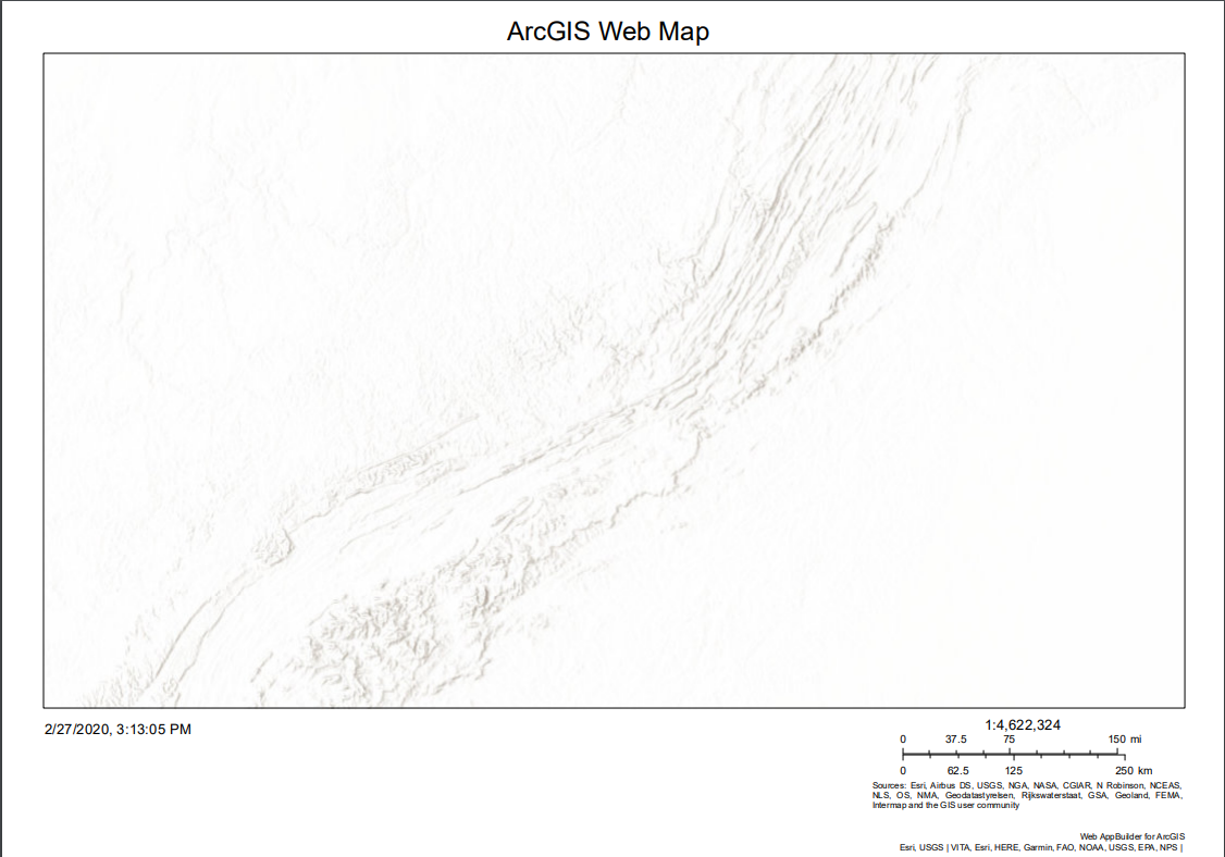
- Mark as New
- Bookmark
- Subscribe
- Mute
- Subscribe to RSS Feed
- Permalink
Thanks Raya.
Can you pls try using the print service off a Esri SampleServer? It worked for me.
Would it be possible the firewall is blocking accessing arcgis.com domain?
here is what I'd do:
- log on to the machine that is running print service
- as ArcSOC account
- open a web browser
- try to access https://cdn.arcgis.com/sharing/rest/content/items/7dc6cea0b1764a1f9af2e679f642f0f5/resources/styles/...
also, are you using the print service that comes installed with ArcGIS Enterprise?
- Mark as New
- Bookmark
- Subscribe
- Mute
- Subscribe to RSS Feed
- Permalink
Hi Tanu,
1. The AGOL service does print the services in the json I sent earlier. But I need the enterprise service to work with our app.
2. I loged on with the account running the ArcSOC and accessed access the json.
3. I am using the printing service that came with the ArcGIS Enterprise and as mantioned before tried with a custom service as well, but none of them worked for me. Same problem with cached services on both.
Raya.
- Mark as New
- Bookmark
- Subscribe
- Mute
- Subscribe to RSS Feed
- Permalink
Hi Raya Kogan,
I think at this point it is best to reach out to Esri Support. They should be able to dig in further and help you resolve this issue.
Sorry couldn't be any big help.
Tanu