- Home
- :
- All Communities
- :
- Events
- :
- ArcGIS User Seminar and Workshop
- :
- ArcGIS User Seminar and Workshop Questions
- :
- Problem constructing a Network dataset
- Subscribe to RSS Feed
- Mark Topic as New
- Mark Topic as Read
- Float this Topic for Current User
- Bookmark
- Subscribe
- Mute
- Printer Friendly Page
Problem constructing a Network dataset
- Mark as New
- Bookmark
- Subscribe
- Mute
- Subscribe to RSS Feed
- Permalink
- Report Inappropriate Content
Hi,
When I try to create a network dataset from a SHAPEFILE I get the error: "could not create network dataset". I am following all the steps although most of what I found refer to using a GEODATABASE instead of a shapefile, so perhaps this is the problem. Can anyone help??
Thanks
David
- Mark as New
- Bookmark
- Subscribe
- Mute
- Subscribe to RSS Feed
- Permalink
- Report Inappropriate Content
Hi David,
It would probably be more productive to ask this in the Network Analyst space. What steps are you following?
Creating a network dataset—Help | ArcGIS Desktop has the following for creating network datasets from shapefiles:
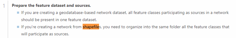
How many shapefile sources do you have and are they organized in the same folder? Is there a reason that you're using shapefiles; or would it be possible to import your data into a geodatabase feature dataset and create a network dataset from that?
- Mark as New
- Bookmark
- Subscribe
- Mute
- Subscribe to RSS Feed
- Permalink
- Report Inappropriate Content
Hi Kory, here are the steps:
1) Open ArcCatalog and navigate to my shapefile of railroads in the US
2) Right click on it -> New -> Network dataset
3) name it railroads_ND
4) click yes to model turns
5) click connectivity -> I see source: the railroad file, connectivity policy: end_point, number 1 checked
6) How would you lie to model the elevation of your netwrok features? Here I choose 'None' because I don't have elevation fields (should I set elevation fields> if so, how??)
7) Do you want to establish directions? Yes. In the Network Direction Properties I choose 'RRname" as the name
😎 Finish
I then get the message "could not create the newtork"
Thanks!!
PS. I will ask this in the Network Analyst space
- Mark as New
- Bookmark
- Subscribe
- Mute
- Subscribe to RSS Feed
- Permalink
- Report Inappropriate Content
Kory,
I am using only one shapefile. I could try to import this into a geodatabase feature dataset if you think that would solve the problem