- Home
- :
- All Communities
- :
- Products
- :
- ArcGIS Network Analyst
- :
- ArcGIS Network Analyst Questions
- :
- How do I combine multiple network datasets?
- Subscribe to RSS Feed
- Mark Topic as New
- Mark Topic as Read
- Float this Topic for Current User
- Bookmark
- Subscribe
- Mute
- Printer Friendly Page
How do I combine multiple network datasets?
- Mark as New
- Bookmark
- Subscribe
- Mute
- Subscribe to RSS Feed
- Permalink
Hi, How do I go about building a network dataset of 3 modes of transportation? The aim of my project is to determine shortest routes between locations using the available transportation options. My study area is NYC.
Do I build a network data set for the train lines, bus routes and ferries or is there a way to build them into 1?
How do i design it to make transfers between transportation options?
Also any tutorials or web courses to help with this will be appriciated.
- Mark as New
- Bookmark
- Subscribe
- Mute
- Subscribe to RSS Feed
- Permalink
Hi Adeola Awe,
Did you have a look at this tutorial?
About the ArcGIS Network Analyst extension tutorial—Help | ArcGIS Desktop
It contains 12 exercises and comes with a set of Tutorial data which you can download for free.
And the second exercise is called Creating a multimodal network dataset, so this should cover your question about the 3 modes of transportation: bus, train and ferry.
Hope this helps,
Egge-Jan
- Mark as New
- Bookmark
- Subscribe
- Mute
- Subscribe to RSS Feed
- Permalink
After having completed (Exercise 3: Finding the best route using a network dataset—Help | ArcGIS Desktop ) in the official Esri Network Analyst Tutorial, I decided to find a route in the multimodal dataset (Exercise 2: Creating a multimodal network dataset—Help | ArcGIS Desktop ), to see how it functions. After adding several network locations along an intentionally long route, I pressed Solve. I was quite surprised to find that the route chosen took walking along the streets as the only transportation mode available (despite railway stations and lines being included in the dataset).
I placed my origin and destination points quite far apart close to metro entrances, so I assumed that the directions would include walking to that first metro entrance, traveling on the train to the last metro entrance, exiting the station and walking to the destination point. The route ArcMap gave me indicated I would have to walk 3 hrs 46 mins along the streets to get to my destination!
How do I ensure that the route chosen uses all available forms of transport to find the shortest route?
- Mark as New
- Bookmark
- Subscribe
- Mute
- Subscribe to RSS Feed
- Permalink
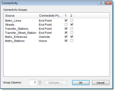
Did you set the connectivity and elevation policies?
Connectivity in the ArcGIS Network Analyst extension begins with the definition of connectivity groups. Each edge source is assigned to exactly one connectivity group, and each junction source can be assigned to one or more connectivity groups. A connectivity group can contain any number of sources. How network elements connect depends on which connectivity groups the elements are in. For example, two edges created from two distinct source feature classes can connect if they are in the same connectivity group. If they are in separate connectivity groups, the edges won't connect unless they are joined by a junction that participates in both connectivity groups.
Exercise 2: Creating a multimodal network dataset—Help | ArcGIS Desktop
- Mark as New
- Bookmark
- Subscribe
- Mute
- Subscribe to RSS Feed
- Permalink
Hi
Egge-Jan Pollé 's Blog Thanks for the prompt reply.
Yes, I have set the connectivity and also the elevation policies? as said in the tutorial
PedestrianTime(Minutes), DriveTime(Minutes) and Meter(Meters) as the options in impedance
Regards
- Mark as New
- Bookmark
- Subscribe
- Mute
- Subscribe to RSS Feed
- Permalink
Make sure that the restriction DrivingAVehicle is turned off when you are using PedestrianTime impedance.
Jay Sandhu
- Mark as New
- Bookmark
- Subscribe
- Mute
- Subscribe to RSS Feed
- Permalink
So, have you found a solution?