- Home
- :
- All Communities
- :
- Products
- :
- ArcGIS Maps for Adobe CC
- :
- ArcGIS Maps for Adobe CC Questions
- :
- "Error 400: Failed" when syncing map into artwork ...
- Subscribe to RSS Feed
- Mark Topic as New
- Mark Topic as Read
- Float this Topic for Current User
- Bookmark
- Subscribe
- Mute
- Printer Friendly Page
"Error 400: Failed" when syncing map into artwork layers
- Mark as New
- Bookmark
- Subscribe
- Mute
- Subscribe to RSS Feed
- Permalink
Hi,
I am trying to import from an ArcGIS Webmap into Adobe Illustrator 2019 using ArcGIS Maps for Creative Cloud.
I can preview the map in the Compilation window, but when I click the "Sync map into artwork layers" button, after a few seconds I get the message "Error 400: Failed". The report file contains no further information.
This only happens with a map I have created. I can import other maps successfully. The URL of the webmap I am trying to import is https://tomwillsdev.maps.arcgis.com/home/item.html?id=d56c30d08e6f4a65b1bacbfe943ab26b
What should I do to resolve the problem?
Tom
- Mark as New
- Bookmark
- Subscribe
- Mute
- Subscribe to RSS Feed
- Permalink
Hi Tom,
Thanks for reaching out and sharing the info. However, appears that the webmap url cannot be accessed. Perhaps the item needs to be made public or you may need to add one of us to your ArcGIS Online org. Can you pls share the item for us to take a look at?
Thanks
Madhura
- Mark as New
- Bookmark
- Subscribe
- Mute
- Subscribe to RSS Feed
- Permalink
Hi Tom,
I can access your webmap. We'll take a look at it and let you know what we find.
Thanks,
Steve
- Mark as New
- Bookmark
- Subscribe
- Mute
- Subscribe to RSS Feed
- Permalink
Hi Tom,
It looks like there's an issue with the 'Places' layer in your webmap. I'm not exactly sure why, but if you change the highlighted 'X' symbol shown below to something else it should work for you:
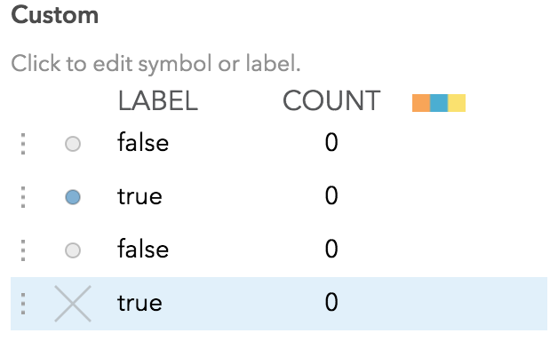
Let me know if you have further issues. We'll also continue to look into this issue and resolve it for a future release.
Thanks,
Steve
- Mark as New
- Bookmark
- Subscribe
- Mute
- Subscribe to RSS Feed
- Permalink
Hi Steve,
Thanks so much for looking into this. Changing the X symbol did not resolve the problem for me, but the I tried replacing the different location symbols with a single symbol, and the export worked, so I can work around this for now.
In case it is useful for troubleshooting, I wonder if it may be relevant that I was using a custom expression to determine the location symbol?
Tom
- Mark as New
- Bookmark
- Subscribe
- Mute
- Subscribe to RSS Feed
- Permalink
Hmm, interesting that changing the symbol didn't work for you, but I'm glad you were able to workaround the issue.
I also thought that the custom expression might be the problem. Changing it did resolve the issue as well, but I think that's because it resets the symbology when you do that. So far for us, that one 'X' symbol seems to be the root cause. We'll keep investigating and let you know what we find.
Thanks,
Steve
- Mark as New
- Bookmark
- Subscribe
- Mute
- Subscribe to RSS Feed
- Permalink
Hi Steve and colleagues,
I created a new map based on the last one, and I'm running into the error 400 again.
Would you be able to let me know which layer is causing the problem this time please?
The new map is at https://tomwillsdev.maps.arcgis.com/home/item.html?id=b097c5578bbf42fa98bbe737b1f05ff1
Many thanks,
Tom
- Mark as New
- Bookmark
- Subscribe
- Mute
- Subscribe to RSS Feed
- Permalink
Hi Tom,
It looks like the issue is with the 'Finances' layer. The dot style on the line appears to not be supported, changing it to solid fixes the problem:

I also tested this webmap on our internal development codebase and I don't see the same issue. We'll look into this a bit further.
Thanks,
Steve
- Mark as New
- Bookmark
- Subscribe
- Mute
- Subscribe to RSS Feed
- Permalink
Hi Steve,
Thanks for looking into this. Changing the line style to solid seemed to work and I was able to export the map once.
However, it does not seem to be working reliably - when I repeat the process, I am seeing various error messages, even without making any changes to the map in Map Viewer.
The new error messages are:
ERROR 400: java.lang.Exception: Could not service request
or sometimes:
ERROR 18: failed to load feature collection service layer
I would be very grateful to know if there is anything going on behind the scenes that may be affecting this, as I would like to do some further map exports.
Kind regards,
Tom
- Mark as New
- Bookmark
- Subscribe
- Mute
- Subscribe to RSS Feed
- Permalink
Hello,
I'm having a similar issue.. I get "java lang exception error 400" when attempting to sync my compilation map to the art board. The item is: https://ufl.maps.arcgis.com/home/item.html?id=33509270162844e5ac323a5857c4fa2f
My online arcGIS map with this layer is: https://ufl.maps.arcgis.com/home/webmap/viewer.html?webmap=3eb60e3b3c75472cafc33252fd37ea5c
However I would prefer to add the layer in the compilation window instead of importing the web map.
I have been able to successfully sync other maps with other data to the art board.
Thank you!
Eliza