- Home
- :
- All Communities
- :
- Products
- :
- Mapping
- :
- Map Projections Questions
- :
- X Y Data in Attribute Table Questions
- Subscribe to RSS Feed
- Mark Topic as New
- Mark Topic as Read
- Float this Topic for Current User
- Bookmark
- Subscribe
- Mute
- Printer Friendly Page
X Y Data in Attribute Table Questions
- Mark as New
- Bookmark
- Subscribe
- Mute
- Subscribe to RSS Feed
- Permalink
I have 40k points the attribute table has multiple x and y fields all have different numerics. None of them seem to match any coordinate system.
Can someone explain the format of these columns
Projected Coordinate System: NAD_1983_StatePlane_Arizona_Central_FIPS_0202_Feet_Intl
Projection: Transverse_Mercator
False_Easting: 700000.00000000
False_Northing: 0.00000000
Central_Meridian: -111.91666667
Scale_Factor: 0.99990000
Latitude_Of_Origin: 31.00000000
Linear Unit: Foot
thanks
- Mark as New
- Bookmark
- Subscribe
- Mute
- Subscribe to RSS Feed
- Permalink
Probably the quickest way to get an answer to your question would be to contact the provider of the attribute table. They will (or at least should) be able to explain the content of the different fields.
Egge-Jan
- Mark as New
- Bookmark
- Subscribe
- Mute
- Subscribe to RSS Feed
- Permalink
You truncated off the latitude and longitude coordinates, but your Xcoord and Y coord fields appear to be be lat and long
ie
75400100 Is your longitude which for some reason should be
-75.400100 for the western hemisphere (positive for the eastern hemisphere)
similarly for the Ycoordinate.
You could just add two new fields and do the appropriate conversion in the field calculator, then you will actually have coordinates that you can map as a Geographic coordinate system perhaps a GCS WGS84 if the datum is assumed as such
- Mark as New
- Bookmark
- Subscribe
- Mute
- Subscribe to RSS Feed
- Permalink
That is what I thought but the first event field was populated with -44.100 etc then some didn't have -'s the next set had no +/- then last set were truncated.... but appreciate the help thank you
- Mark as New
- Bookmark
- Subscribe
- Mute
- Subscribe to RSS Feed
- Permalink
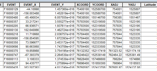
Try mapping the points using the XADJ and YADJ fields and the given coordinate system: NAD_1983_StatePlane_Arizona_Central_FIPS_0202_Feet_Intl. The false easting (x value at center of zone) of the coordinate system is 700000. The XADJ field has values around 700k. I think the XCOORD and YCOORD fields have values in 100th of a foot. This is sometimes used in surveying or engineering.
I wouldn't trust the EVENT_X or EVENT_Y fields. The EVENT_Y field values are nonsensical.
Melita
- Mark as New
- Bookmark
- Subscribe
- Mute
- Subscribe to RSS Feed
- Permalink
1/100th of a foot? now I have heard of everything 
- Mark as New
- Bookmark
- Subscribe
- Mute
- Subscribe to RSS Feed
- Permalink
Melita thanks, nonsensical is a perfect word to describe those numbers!!! I spent several hours of mental work trying to understand them. 