- Home
- :
- All Communities
- :
- Products
- :
- ArcGIS Pro
- :
- ArcGIS Pro Questions
- :
- Anyone have experience with geotag photos to point...
- Subscribe to RSS Feed
- Mark Topic as New
- Mark Topic as Read
- Float this Topic for Current User
- Bookmark
- Subscribe
- Mute
- Printer Friendly Page
Anyone have experience with geotag photos to points, using arrow symbology to indicate photo direction?
- Mark as New
- Bookmark
- Subscribe
- Mute
- Subscribe to RSS Feed
- Permalink
- Report Inappropriate Content
I used the geotag photo to point tool to import photos taken. The azimuth is not being picked up when I look at the attribute table and I have to enter it manually, it appears in the EXIF header for the image. I am also struggling with changing the symbology to an arrow that rotates to indicate azimuth. Any ideas?
- Mark as New
- Bookmark
- Subscribe
- Mute
- Subscribe to RSS Feed
- Permalink
- Report Inappropriate Content
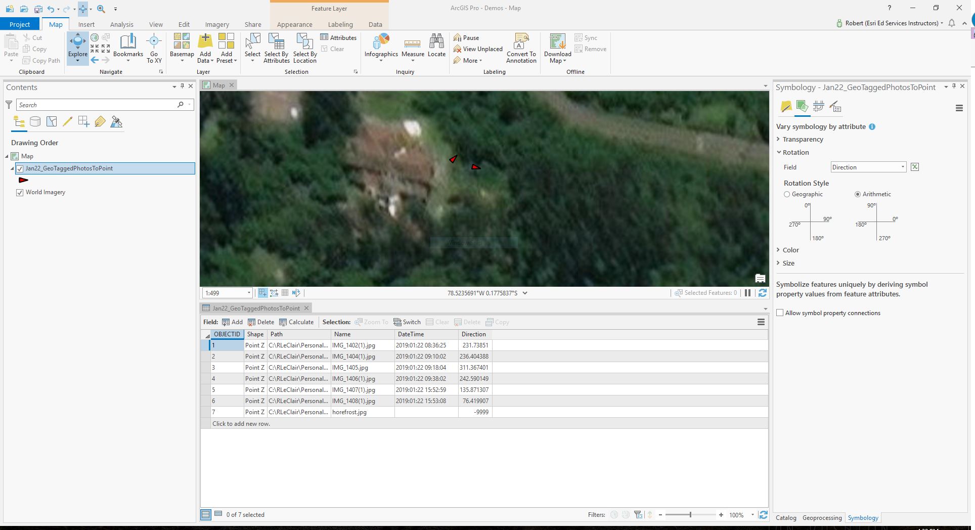
Elizabeth - I kind of tweaked some of the workflows in this thread for the point symbology to get the arrow symbol from the Esri fonts. Then I went to the "Vary symbology by attribute" in the symbology pane where I set the rotation parameter to the direction attribute field using the Arithmetic radio button. It gave me the results I was looking for.
- Mark as New
- Bookmark
- Subscribe
- Mute
- Subscribe to RSS Feed
- Permalink
- Report Inappropriate Content
Thank you Robert, I found the thread useful but the central question I am still seeking support with...
I am able to use symbology to rotate and indicate direction when I enter direction manually into the attribute table. My question now is why the Geotagged Photo to Point tool fails to recognize the EXIF metatag GPSDestBearing tag. I have a colleague that uses an iPhone and doesn't seem to be having the same issue. The photos from my phone (Samsung S9) have the info stored in the EXIF metatag (I needed help accessing that) but the info is not communicating over into ArcPro when I run the tool. I am told EXIF metatag GPSDestBearing tag along with GPSImgDirection are both standards to denote camera azimuth using a smart phone or tablet. The photos I upload through the tool, default -9999 in the direction field. Any advice there?
- Mark as New
- Bookmark
- Subscribe
- Mute
- Subscribe to RSS Feed
- Permalink
- Report Inappropriate Content
I see. What release of ArcGIS Desktop are you using?
- Mark as New
- Bookmark
- Subscribe
- Mute
- Subscribe to RSS Feed
- Permalink
- Report Inappropriate Content
ArcPro
- Mark as New
- Bookmark
- Subscribe
- Mute
- Subscribe to RSS Feed
- Permalink
- Report Inappropriate Content
I found something interesting about Samsung S7's that I wonder if it's carried over to the Samsung S9's - there's a great thread here about a workaround. Maybe it will work?
- Mark as New
- Bookmark
- Subscribe
- Mute
- Subscribe to RSS Feed
- Permalink
- Report Inappropriate Content
In the photos that I click, the bearing is saved with GPSImgDirection Tag in Exif Data. While most image viewers will allow to see the exif data, i use and enjoy IrfanView. In IrfanView, while viewing any image, press I then E, and you should see all the EXIF data there. It even has clickable links to directly go to the location in Google Map or Earth etc, but unfortunately there is no way to plot the direction data in Google Earth or Google Map or Google My Map. I am hoping to use ESRI's ArcGIS for that, and these are my first steps...
- Mark as New
- Bookmark
- Subscribe
- Mute
- Subscribe to RSS Feed
- Permalink
- Report Inappropriate Content
Has there been any updates to this? I have a Samsung S21. Using photos taken via Field Maps will give XYZ values but no direction. Using photos taken via the standard camera does not give XYZ values and directions. And yes, my photos are location tag-enabled ans the location is visible if opened via other means.
Is this only with Samsung phones? Open Camera workaround also doesn't work. I am using ArcGIS Pro 2.9.1