- Home
- :
- All Communities
- :
- Products
- :
- ArcGIS Pro
- :
- ArcGIS Pro Questions
- :
- Project tool not working
- Subscribe to RSS Feed
- Mark Topic as New
- Mark Topic as Read
- Float this Topic for Current User
- Bookmark
- Subscribe
- Mute
- Printer Friendly Page
Project tool not working
- Mark as New
- Bookmark
- Subscribe
- Mute
- Subscribe to RSS Feed
- Permalink
I am using ArcGIS Pro and I have added 2 XY data point layers onto my map, which both have longitude and latitude coordinates. I need to use the Near tool to calculate nearest distance using these 2 layers but it when I do it will show as decimal degrees so I am trying to get both layers to a projected coordinate system first and then calculate meters. After I use the project tool, I go to check the spatial reference for both of the layers but it is showing both GCS and projected for both of the layers. See picture. Why isn't it just showing the projected one?
So when I use the near tool, the distance units is not decimal degrees but I know it is still wrong. I am trying to get it into meters. What I am doing wrong?
Thanks in advance.
- Mark as New
- Bookmark
- Subscribe
- Mute
- Subscribe to RSS Feed
- Permalink
did you project to web Mercator? which is a projected coordinate system... it is also useless if you require distance and/or area calculations.
I would project to a better projected coordinate system (ie some UTM or similar for your area)
- Mark as New
- Bookmark
- Subscribe
- Mute
- Subscribe to RSS Feed
- Permalink
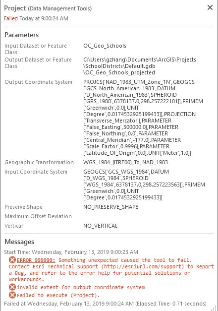
Hello I tried projecting it a UTM (NAD 1983) but am getting this error: Do you know how to resolve this? Thanks.
- Mark as New
- Bookmark
- Subscribe
- Mute
- Subscribe to RSS Feed
- Permalink
Gary, have you examined the extent (through layer properties) to see what your coordinates actually are?
Maybe it is a projected file, defined as unprojected, or vica versa.
In any event the 'extent' doesn't fit into the utm zone if it were to be projected,
Report the left, top, right and bottom of the extent of your data first
- Mark as New
- Bookmark
- Subscribe
- Mute
- Subscribe to RSS Feed
- Permalink
Here is a screenshot of one of the layers extent. I just need to get this into the projected coordinate system so I can calculate the correct distance using the near tool. The data has XY longitude latitude fields and was added as point data. 
- Mark as New
- Bookmark
- Subscribe
- Mute
- Subscribe to RSS Feed
- Permalink
maybe utm zone 11N
Lat/Lon and UTM Converstion - Yellowstone Research Coordination Network
- Mark as New
- Bookmark
- Subscribe
- Mute
- Subscribe to RSS Feed
- Permalink
Thank you, that worked and it is now in UTM and the linear unit is meters. However this did not change the values that were calculated after I use the near tool. The "NEAR_DIST" field that was created still shows the same values as when it was projected to web mercator.
- Mark as New
- Bookmark
- Subscribe
- Mute
- Subscribe to RSS Feed
- Permalink
meaning your locations were close together. My warning is more general... don't use web Mercator for anything that requires geometry calculations unless you understand the ramifications
- Mark as New
- Bookmark
- Subscribe
- Mute
- Subscribe to RSS Feed
- Permalink
From my somewhat limited understanding of this .... and I welcome to be corrected here
If you have defined a vertical coordinate system, then you may get up to 3 spatial references listed here. The top one is the projection of your data. The second one describes the modelled shape of the earth - your datum/ellipsoid/spheroid (also referred to as geographic coordinate system by Esri). And if you have a third one, it would be the vertical coordinate system. From your screengrab, you will notice that the two spatial references are different as only the second one refers to the datum and spheroid.
If your data is not projected, and it is in geographic coordinates, then only one spatial reference will be provided to you (the second geographic coordinate system in your screengrab with spheroid and ellipsoid).
Do see Coordinate systems, projections, and transformations—Properties of maps | ArcGIS Desktop
- Mark as New
- Bookmark
- Subscribe
- Mute
- Subscribe to RSS Feed
- Permalink
Gary,
For your original question, a projected coordinate system is always based upon a geographic coordinate system (GCS). The GCS defines size and shape of the earth model being used, then the PCS describes how to convert it to a 2D surface/plane.
Melita