- Home
- :
- All Communities
- :
- Products
- :
- ArcGIS Pro
- :
- ArcGIS Pro Questions
- :
- Scale bar in ArcgisPro layout
- Subscribe to RSS Feed
- Mark Topic as New
- Mark Topic as Read
- Float this Topic for Current User
- Bookmark
- Subscribe
- Mute
- Printer Friendly Page
- Mark as New
- Bookmark
- Subscribe
- Mute
- Subscribe to RSS Feed
- Permalink
Hi, I was wondering if it is possible to change the scale of the scale bar manually or use an other reference than the scale of the Map Frame in the layout of ArcgisPro.
Thank you
Solved! Go to Solution.
Accepted Solutions
- Mark as New
- Bookmark
- Subscribe
- Mute
- Subscribe to RSS Feed
- Permalink
Scale bar accuracy depends on the spatial reference of the map, the scale of the map and where on the map you are measuring distance. It doesn't matter kind of data (raster imagery, vector features) are in the map. Here are some links for more information on scale bars.
Choosing the best way to indicate map scale
Scale bar inaccurate on a projected geo-referenced map image, why?
Tom
- Mark as New
- Bookmark
- Subscribe
- Mute
- Subscribe to RSS Feed
- Permalink
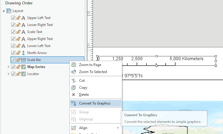
As in here?

But I suspect you are looking for other choices than Map Frame or None or changing the units.
- Mark as New
- Bookmark
- Subscribe
- Mute
- Subscribe to RSS Feed
- Permalink
Hi Gauthier,
What is it that you want to scale bar to measure? If it is not a map, as Dan suspects above, I don't think you can use a scale bar element as it is designed to work with a map. You can convert a scale bar to a set of graphic elements and change these elements as you see fit.
Hope this helps.
Tom
- Mark as New
- Bookmark
- Subscribe
- Mute
- Subscribe to RSS Feed
- Permalink
Hi Tom and Dan, thanks for the answers.
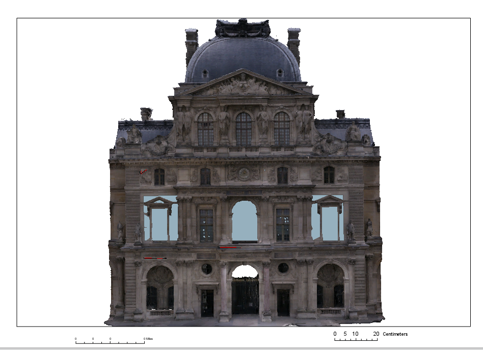
To set a context, I am going to explain my goal with the scale bar. I work with 3D model and my ultimate goal is to have my scale bar related to my 3D model depending on my zoom and my distance from the model or a plan that I created in the same plan as the model as you can see on the picture for example.
The problem, I think, is that Arcgis Pro use the vertical axe or the elevation from the ground to define the scale of the scene, as we are supposed to work on map (more like 2,5 D and not real 3D) and it seems more logical.
Other way, the Convert To Graphics tool that you told me about can work as i can create my own scale bar and adjust it to the model as I can measure distance on the model and the size of the paper in the layout.
If you know how to create a scale bar related to a plan or a model, I will be happy to know about it.
Otherwise thank again for the fast answer !
- Mark as New
- Bookmark
- Subscribe
- Mute
- Subscribe to RSS Feed
- Permalink
Gauthier,
Here's some information that I got from one of our 3D experts.
Scale is continuous and changing across a 3D view, so the traditional idea of scale bars don’t work in scenes - things that are far away are at a different scale than things that are closer. Technically something could be done in Parallel (aka “isometric”) view mode, but we don’t have the math / conversion-factor for that available.
For an in-scene solution (ie: creating an object that displays in the scene itself), he could use the Cage symbol. This builds a 3D grid around an object, where the number, gap, and heights of the grid lines can be configured (as needed).
Steps:
- Add a 2D polygon feature around the model (best practice – rectangular shape with well-defined side lengths, like “100m”)
- Drag that layer into the 3D category in the TOC
- Click symbol in TOC to open Symbology pane, search All Styles for “cage”, choose the “Parcel Cage” symbol
- Configure the symbol - height of cage, number of grid lines, display of numbers, colors, etc
- Bonus points: use attribute-driven symbol properties to make different cage symbols per feature
Tom
- Mark as New
- Bookmark
- Subscribe
- Mute
- Subscribe to RSS Feed
- Permalink
Thank you a lot Tom ! I can't try this right now but I will definitly try it soon. I get the point of this solution and the result could really fit what I was aiming for.
Gauthier
- Mark as New
- Bookmark
- Subscribe
- Mute
- Subscribe to RSS Feed
- Permalink
Having read this thread is it possible to have an accurate scale bar when using imagery. If so how?
- Mark as New
- Bookmark
- Subscribe
- Mute
- Subscribe to RSS Feed
- Permalink
Scale bar accuracy depends on the spatial reference of the map, the scale of the map and where on the map you are measuring distance. It doesn't matter kind of data (raster imagery, vector features) are in the map. Here are some links for more information on scale bars.
Choosing the best way to indicate map scale
Scale bar inaccurate on a projected geo-referenced map image, why?
Tom
- Mark as New
- Bookmark
- Subscribe
- Mute
- Subscribe to RSS Feed
- Permalink
Tom,
thanks for the steer.
I now have a working scale bar! I knew it would be something simple.
Steve