Turn on suggestions
Auto-suggest helps you quickly narrow down your search results by suggesting possible matches as you type.
Cancel
- Home
- :
- All Communities
- :
- User Groups
- :
- Cartography and Maps
- :
- Questions
- :
- Cartographic representation for overlaping lines
Options
- Subscribe to RSS Feed
- Mark Topic as New
- Mark Topic as Read
- Float this Topic for Current User
- Bookmark
- Subscribe
- Mute
- Printer Friendly Page
Cartographic representation for overlaping lines
Subscribe
209
0
01-09-2018 01:23 AM
01-09-2018
01:23 AM
- Mark as New
- Bookmark
- Subscribe
- Mute
- Subscribe to RSS Feed
- Permalink
- Report Inappropriate Content
Hello !
I have a project in which I need to do a series of tasks related to cartographic representation.
In the field of urban planning and transport, a feature class of polylines represents urban projects, such as :
- new bus line from point A to point B
- better connexion for pedestrians between point A and point C
- etc..
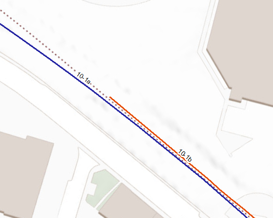
Sometimes, the lines representing two different projects overlap and I need to create an alternate geometry for one of the projects.
- My first question is : what method to apply to detect conflicting lines and how to perform displacement?
- Is the tool DetectGraphicConflict appropriate to detect conflicts between lines ?
- To perform the displacement, I was thinking of doing it manually on each feature. The time required would be acceptable. The alternative would be, apparently to use the tool ResolveRoadConflicts. But in this case, I'd need to fill in the hierarchy attribute.
- My second question is how to maintain the data, and copy it between gdbs and publish a map using the representation
- I need to be able to edit both the original geometry and the representation seperatly.
- I need to be able to copy the feature class from a file gdb to an SDE gdb, conserving the representations intact.
- I need to publish a map to ArcGIS Server which would use the cartographic representation.
In the image below, line 10-1b in orange has been displaced.
Does anyone out there have experience with using carto representation in a similar situation? Any recommendations or advice?
Thanks.
Tim
0 Replies