- Home
- :
- All Communities
- :
- Products
- :
- ArcGIS Pro
- :
- ArcGIS Pro Questions
- :
- Why the meter “display unit” appears with directio...
- Subscribe to RSS Feed
- Mark Topic as New
- Mark Topic as Read
- Float this Topic for Current User
- Bookmark
- Subscribe
- Mute
- Printer Friendly Page
Why the meter “display unit” appears with direction letters (W, E, N, S) in ArcGIS Pro?
- Mark as New
- Bookmark
- Subscribe
- Mute
- Subscribe to RSS Feed
- Permalink
- Report Inappropriate Content
Why the meter “display unit” appears with direction letters (W, E, N, S) in ArcGIS Pro?
There is a major different between ArcGIS Pro and ArcMap as the first layer is added. In ArcMap, the coordinate system of data frame is defined by the first layer added. In ArcGIS Pro, this appears not to happen.
However, I couldn’t figure out why the meter “display unit” appears with direction letters (W, E, N, S) in ArcGIS Pro. Is there a way to let them appear the same as in ArcMap?
Jamal Numan
Geomolg Geoportal for Spatial Information
Ramallah, West Bank, Palestine
- Mark as New
- Bookmark
- Subscribe
- Mute
- Subscribe to RSS Feed
- Permalink
- Report Inappropriate Content
I am suspecting that in the Pro map, the data are in Geographic Coordinates and there is no projection set, so it showsn the 'm' for meters but the geographic designators as well (ie N,S,E,W) as a clue that you can't just set a map to show meters unless the map has a defined projection.
- Mark as New
- Bookmark
- Subscribe
- Mute
- Subscribe to RSS Feed
- Permalink
- Report Inappropriate Content
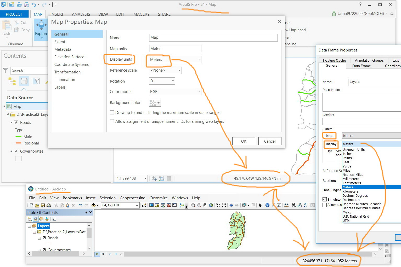
For example, in the screenshot below, the added layer has a defined “protected coordinate system”, nevertheless, geographic designators (N,S,E,W) are still there.

Jamal Numan
Geomolg Geoportal for Spatial Information
Ramallah, West Bank, Palestine
- Mark as New
- Bookmark
- Subscribe
- Mute
- Subscribe to RSS Feed
- Permalink
- Report Inappropriate Content
Oh that's easy

- Mark as New
- Bookmark
- Subscribe
- Mute
- Subscribe to RSS Feed
- Permalink
- Report Inappropriate Content
My question here is why they (N, S, E, W) got visible in ArcGIS Pro while we have lived without them for years and years. Do we really need to display them now in ArcGIS Pro?
Jamal Numan
Geomolg Geoportal for Spatial Information
Ramallah, West Bank, Palestine
- Mark as New
- Bookmark
- Subscribe
- Mute
- Subscribe to RSS Feed
- Permalink
- Report Inappropriate Content
Just a guess here - but ArcMap as it was designed used the minus side to signify E and S for coordinate systems. In Pro, the Developers made it more obvious using N-S-E-W designations vs. plus/minus. I'd say an UI enhancement is all.
- Mark as New
- Bookmark
- Subscribe
- Mute
- Subscribe to RSS Feed
- Permalink
- Report Inappropriate Content
Its a new age!