- Home
- :
- All Communities
- :
- Products
- :
- ArcGIS StoryMaps
- :
- Classic Esri Story Maps Questions
- :
- Maps in my storymap do not fully display. Size lim...
- Subscribe to RSS Feed
- Mark Topic as New
- Mark Topic as Read
- Float this Topic for Current User
- Bookmark
- Subscribe
- Mute
- Printer Friendly Page
Maps in my storymap do not fully display. Size limit?
- Mark as New
- Bookmark
- Subscribe
- Mute
- Subscribe to RSS Feed
- Permalink
The two U.S. maps I have uploaded in my storymap show two thirds of the data. Basically, the U.S. south is is blank. Is there a size limit in the maps we upload?
Thank you!
Solved! Go to Solution.
Accepted Solutions
- Mark as New
- Bookmark
- Subscribe
- Mute
- Subscribe to RSS Feed
- Permalink
Hi Mila,
You can try one of two things. I'd recommend the first.
- Make tiles from your features. See Publish hosted tile layers—ArcGIS Online Help | ArcGIS. You can still have pop-ups with tiles as long as you also have a feature layer of the same data (which you already do). You just add the tile layer to the map and then use the feature layer to define the pop-ups. If you enable pop-ups on a tile layer it may ask you to specify which feature layer should drive the pop-ups.
OR
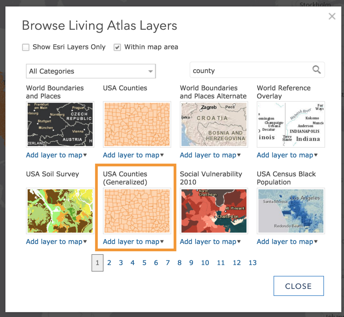
- Make sure you are using a generalized county layer. If the layer you are using has very detailed county data it will be very slow to draw. You need to generalize your data (in Pro) before publishing or use a generalized layer from the Living Atlas to join your attributes to. Features will still draw more slowly than tiles, but using a generalized layer should at least speed it up to the point where the entire layer will draw.
If you expect your readers to zoom in to large scales you can keep the detailed feature layer in the map, but make it visible only at those large scales by setting a Visibility Range.
Owen
Lead Product Engineer | StoryMaps
- Mark as New
- Bookmark
- Subscribe
- Mute
- Subscribe to RSS Feed
- Permalink
Got link to the story map and the web maps. or screenshot if they are not public? If you open the web map and view it outside of a Story Map app, does it draw correctly. Also which of the Story Map app templates are you using? A
Rupert
- Mark as New
- Bookmark
- Subscribe
- Mute
- Subscribe to RSS Feed
- Permalink
Any advice?
- Mark as New
- Bookmark
- Subscribe
- Mute
- Subscribe to RSS Feed
- Permalink
Hi Rupert,
I am using a "side accordeon" template. The map is not public, but here are the two screen shots. When I open the map in ArcPro and ArcGIS online there are no problems (just a little slow in ArcGIS online)
Thank you for your help!
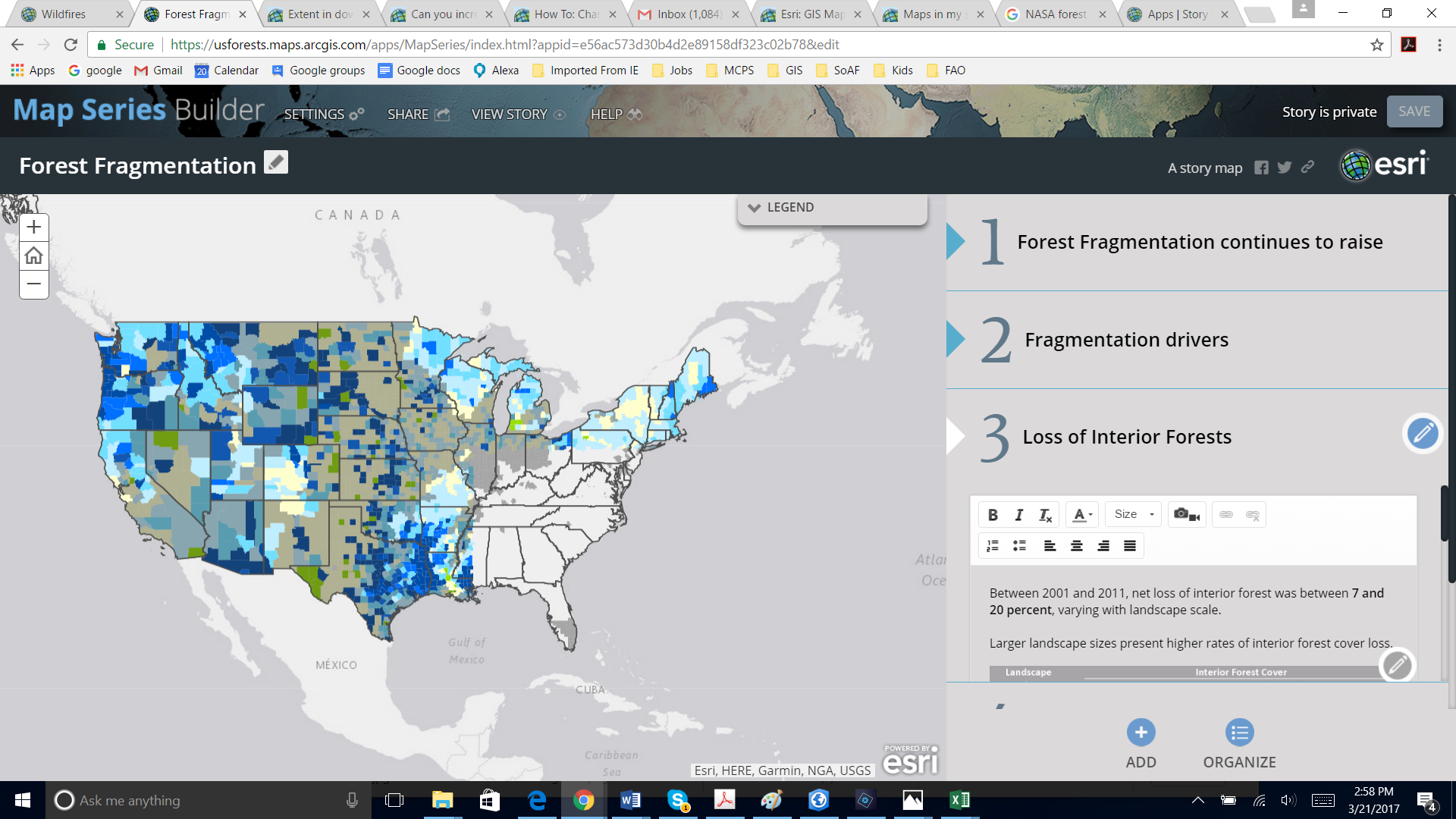
.png)
- Mark as New
- Bookmark
- Subscribe
- Mute
- Subscribe to RSS Feed
- Permalink
Hi Mila,
I would recommend creating tile layers out of your features layers to use in your story map. It looks like you are showing detailed counties at a national scale, so that's a lot of information for the app to draw. Tile layers will draw much faster.
To create tiles just go to the item page of your published feature service on ArcGIS Online and click Publish > Tile layer. Or you can create tiles in ArcGIS Pro and upload them to ArcGIS Online to save credits.
Owen
Lead Product Engineer | StoryMaps
- Mark as New
- Bookmark
- Subscribe
- Mute
- Subscribe to RSS Feed
- Permalink
Hi Owen,
Thank you for your reply. I tried your suggestion. The problem is that I
would like the map to be interactive so the reader can click the map and
read the info that the pop-up shows. Any suggestion about how to get
around? I have seeing in some of ESRI training materials examples of making
story maps with identical county level data. It looks so easy...
Thank you again for your support!
Mila
- Mark as New
- Bookmark
- Subscribe
- Mute
- Subscribe to RSS Feed
- Permalink
Hi Mila,
You can try one of two things. I'd recommend the first.
- Make tiles from your features. See Publish hosted tile layers—ArcGIS Online Help | ArcGIS. You can still have pop-ups with tiles as long as you also have a feature layer of the same data (which you already do). You just add the tile layer to the map and then use the feature layer to define the pop-ups. If you enable pop-ups on a tile layer it may ask you to specify which feature layer should drive the pop-ups.
OR
- Make sure you are using a generalized county layer. If the layer you are using has very detailed county data it will be very slow to draw. You need to generalize your data (in Pro) before publishing or use a generalized layer from the Living Atlas to join your attributes to. Features will still draw more slowly than tiles, but using a generalized layer should at least speed it up to the point where the entire layer will draw.
If you expect your readers to zoom in to large scales you can keep the detailed feature layer in the map, but make it visible only at those large scales by setting a Visibility Range.
Owen
Lead Product Engineer | StoryMaps
- Mark as New
- Bookmark
- Subscribe
- Mute
- Subscribe to RSS Feed
- Permalink
Thank you so much Owen, I appreciate your advice. This was extremely helpful.
Mila