- Home
- :
- All Communities
- :
- Products
- :
- ArcGIS Spatial Analyst
- :
- ArcGIS Spatial Analyst Questions
- :
- Calculate upstream Area
- Subscribe to RSS Feed
- Mark Topic as New
- Mark Topic as Read
- Float this Topic for Current User
- Bookmark
- Subscribe
- Mute
- Printer Friendly Page
- Mark as New
- Bookmark
- Subscribe
- Mute
- Subscribe to RSS Feed
- Permalink
- Report Inappropriate Content
- I have a couple little streams.
- I have a DEM
- I created a Flow Direction from the DEM
I now want to create a Raster of all area above the streams. I did a Basin but that seems to give me data below the streams as well as this is based off of the DEM and not looking at the Stream Segments.
I don't have to use the Streams per say...I can use a point along the stream and then I want to create a raster of the area upstream of that point.
Thoughts?
Solved! Go to Solution.
Accepted Solutions
- Mark as New
- Bookmark
- Subscribe
- Mute
- Subscribe to RSS Feed
- Permalink
- Report Inappropriate Content
I'd use a Snap Pour Point (see link below) with the "pour point" point feature class for the best results. If I remember correctly, one can do a Watershed without using Snap Pour Point in locating the points, but in the past I got weird results sometimes, whereas with Snap Pour Point it was good.
Better results will be obtained if the Snap Pour Point tool is used beforehand to help locate the pour points to cells of high accumulated flow.
ArcGIS Help (10.2, 10.2.1, and 10.2.2)
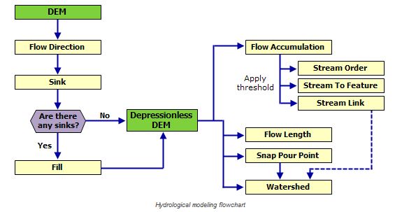
In this case Flow Length is not needed for Watershed, so you can skip that one.
As for the Flow Accumulation, the diagram shows it connecting back to Watershed through Stream Link, but I am not recalling how that fits back into Watershed and not seeing it as an input. It's been a couple of years since I ran this, so will have to scratch my head and try to remember what the connection is. Maybe someone who has worked with this more recently can comment on the Flow Accumulation - Stream Link connection to Watershed?
EDIT - Figured out part of it. The Snap Pour Point (Spatial Analysis) process needs Flow Accumulation as an input. Still not sure about the Stream Link connection, though.....
ArcGIS Help (10.2, 10.2.1, and 10.2.2) - Snap Pour Point (Spatial Analysis)
Chris Donohue, GISP
- Mark as New
- Bookmark
- Subscribe
- Mute
- Subscribe to RSS Feed
- Permalink
- Report Inappropriate Content
Watershed may be the way to go instead of Basins. However, be aware that one will first need to process the DEM first to create a "Depressionless" DEM, then run several processes to come up with the inputs for Watershed. In other words, there are several processes to do before running Watershed. Avoid the temptation to skip some steps, as this will lead to less than desirable results.
ArcGIS Help (10.2, 10.2.1, and 10.2.2) -Deriving Runoff Characteristics
ArcGIS Help (10.2, 10.2.1, and 10.2.2) - Watershed (Spatial Analyst)
Chris Donohue, GISP
- Mark as New
- Bookmark
- Subscribe
- Mute
- Subscribe to RSS Feed
- Permalink
- Report Inappropriate Content
Thanks for the response...I am good up to the Depressionless DEM...then get confused on which way to go... I have two locations along the stream that I want to reference and get the watershed/area upstream of those 2 points. Not sure if I need to do Flow Length or Snap Pour Point or both then use that output with the watershed tool....
- Mark as New
- Bookmark
- Subscribe
- Mute
- Subscribe to RSS Feed
- Permalink
- Report Inappropriate Content
I'd use a Snap Pour Point (see link below) with the "pour point" point feature class for the best results. If I remember correctly, one can do a Watershed without using Snap Pour Point in locating the points, but in the past I got weird results sometimes, whereas with Snap Pour Point it was good.
Better results will be obtained if the Snap Pour Point tool is used beforehand to help locate the pour points to cells of high accumulated flow.
ArcGIS Help (10.2, 10.2.1, and 10.2.2)
In this case Flow Length is not needed for Watershed, so you can skip that one.
As for the Flow Accumulation, the diagram shows it connecting back to Watershed through Stream Link, but I am not recalling how that fits back into Watershed and not seeing it as an input. It's been a couple of years since I ran this, so will have to scratch my head and try to remember what the connection is. Maybe someone who has worked with this more recently can comment on the Flow Accumulation - Stream Link connection to Watershed?
EDIT - Figured out part of it. The Snap Pour Point (Spatial Analysis) process needs Flow Accumulation as an input. Still not sure about the Stream Link connection, though.....
ArcGIS Help (10.2, 10.2.1, and 10.2.2) - Snap Pour Point (Spatial Analysis)
Chris Donohue, GISP
- Mark as New
- Bookmark
- Subscribe
- Mute
- Subscribe to RSS Feed
- Permalink
- Report Inappropriate Content
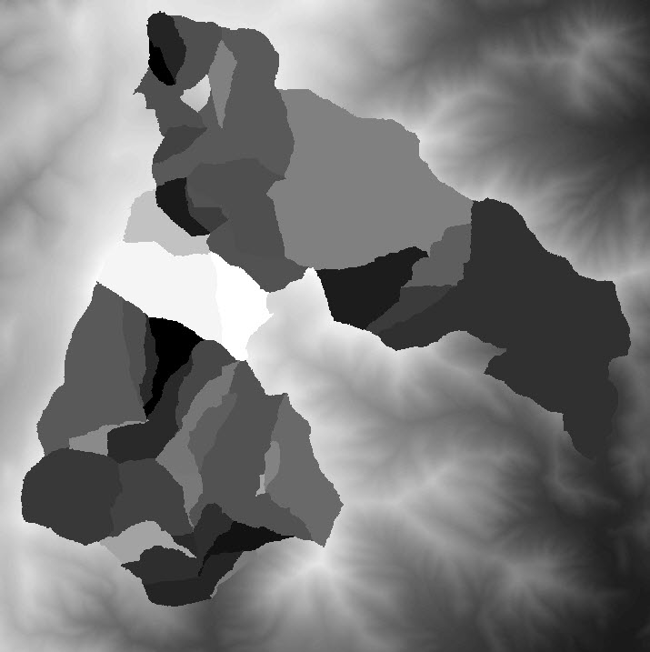
I am not interested in super accurate results....I have attached an image of what I got when I ran the watershed tool with the Flow Direction and DEM as inputs. I need to create a boundary around streams that drain into them. From this boundary I need to get the area draining into the streams....
Thoughts?
- Mark as New
- Bookmark
- Subscribe
- Mute
- Subscribe to RSS Feed
- Permalink
- Report Inappropriate Content
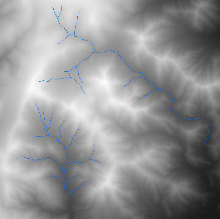
Think i got it....used the Stream Segments as input to the Snap Pour Points and then rant he watershed...got this