Turn on suggestions
Auto-suggest helps you quickly narrow down your search results by suggesting possible matches as you type.
Cancel
- Home
- :
- All Communities
- :
- Developers
- :
- ArcObjects SDK
- :
- ArcObjects SDK Questions
- :
- Anyone have existing C# codes for handling a tool ...
Options
- Subscribe to RSS Feed
- Mark Topic as New
- Mark Topic as Read
- Float this Topic for Current User
- Bookmark
- Subscribe
- Mute
- Printer Friendly Page
Anyone have existing C# codes for handling a tool and button within the same Add-in for ArcMap?
Subscribe
2209
2
04-12-2016 07:45 AM
04-12-2016
07:45 AM
- Mark as New
- Bookmark
- Subscribe
- Mute
- Subscribe to RSS Feed
- Permalink
- Report Inappropriate Content
Just like the actions from the tools: Identify or Measure on ArcMap, where the user's form pop-up, and the mouse point takes effect and puts the data from Map to the form when mouse button down.
2 Replies
04-12-2016
09:36 AM
- Mark as New
- Bookmark
- Subscribe
- Mute
- Subscribe to RSS Feed
- Permalink
- Report Inappropriate Content
Take a look at my post here https://community.esri.com/message/409943#comment-409943 to see if that helps.
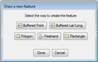
It's written in VB.Net, but it shouldn't be difficult to translate. In this add-in, the DrawFeature form has buttons that when clicked, allow you to interact with the map.
04-12-2016
09:59 AM
- Mark as New
- Bookmark
- Subscribe
- Mute
- Subscribe to RSS Feed
- Permalink
- Report Inappropriate Content
Hi Ken, Thanks a lot. I will see how it works on ArcGIS 10.3.1 or later version.
Peter