- Home
- :
- All Communities
- :
- Developers
- :
- Python
- :
- Python Questions
- :
- arcpy.Clip_management having different output from...
- Subscribe to RSS Feed
- Mark Topic as New
- Mark Topic as Read
- Float this Topic for Current User
- Bookmark
- Subscribe
- Mute
- Printer Friendly Page
arcpy.Clip_management having different output from using Python and not
- Mark as New
- Bookmark
- Subscribe
- Mute
- Subscribe to RSS Feed
- Permalink
Dear All,
I use the Clip in the Raster Processing to clip some grid from a raster file. But the outputs are different from using Python or not.
Here is my code:
import arcpy
import os
from arcpy import env
# Set environment settings
env.workspace = "C:/data"
# Clip the layer, remove the points located outside of Texas boundary
output_path="C:/NDVI/2012/"
# Read datafiles for clip
in_path = "C:/NDVI_data/2012/MOD13A3_out/"
shp_list = []
date_id = []
tile_id = []
for dirpath, dirnames, files in os.walk(in_path):
for f in files:
if f.lower().endswith("_reproj.dat"):
fullpath = os.path.join(dirpath, f)
shp_list.append(fullpath)
date_id.append(f[9:16])
tile_id.append(f[17:23])
# Count the elements in shp_list
N=len(shp_list)
# Clip raster
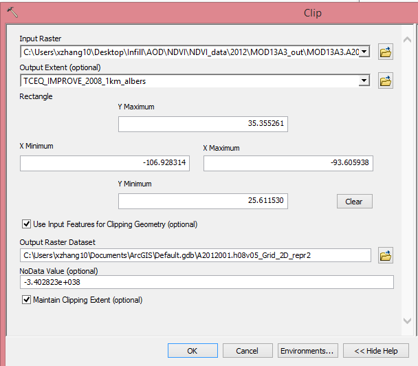
for i in range(0,1):
in_raster = shp_list
out_feature = "NDVI_clip"+date_id+tile_id
Rectangle = "-106.928314 25.611530 -93.605938 35.355261"
Clip_feature = "C://PM_Site/IMPROVE_2011_1km_albers.shp"
arcpy.Clip_management(in_raster,Rectangle,out_feature, Clip_feature,"-999","ClippingGeometry","MAINTAIN_EXTENT")And the output looks like this:
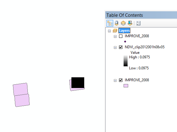
But if I don't use the Python.
The output is looks like this:
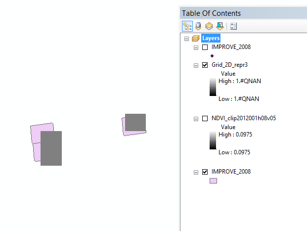
Why there are two grids missing by using the Python?
I will really appreciate your help!
Sue-ying
- Mark as New
- Bookmark
- Subscribe
- Mute
- Subscribe to RSS Feed
- Permalink
note clear in the first image you set the extent to decimal degree coordinates, but you are using an albers (projected) file. Can you confirm the extents in both files as to whether were selected from the layer or typed in and whether in file being clipped has the same coordinates as the clipping file
PS I would check the effect of the checkbox ... maintain clipping extent
- Mark as New
- Bookmark
- Subscribe
- Mute
- Subscribe to RSS Feed
- Permalink
Yes, I'm sure I used the exact same input files. Just the name shows differently because I take the screenshot in different times. Sorry for the confusing.
And I did checked the two boxess, "ClippingGeometry" and "maintain clipping extent".
Using the same input files but the output is different, that confused me.
- Mark as New
- Bookmark
- Subscribe
- Mute
- Subscribe to RSS Feed
- Permalink
If the tools and inputs are the same but outputs are different, I suggest investigating if the environment settings in ArcMap and in the script environment are script are different. Especially check processing extent, output coordinate system, mask.
- Mark as New
- Bookmark
- Subscribe
- Mute
- Subscribe to RSS Feed
- Permalink
Set your Rectangle variable to "#". You don't need to specify an envelope if you are providing a shp as the clipping extent.
Rectangle = "#"