- Home
- :
- All Communities
- :
- Industries
- :
- Water Utilities
- :
- Water Utilities Questions
- :
- If you’re using the Attribute Assistant, we need y...
- Subscribe to RSS Feed
- Mark Topic as New
- Mark Topic as Read
- Float this Topic for Current User
- Bookmark
- Subscribe
- Mute
- Printer Friendly Page
If you’re using the Attribute Assistant, we need your help!
- Mark as New
- Bookmark
- Subscribe
- Mute
- Subscribe to RSS Feed
- Permalink
We’re doing some research into how the Attribute Assistant is being used. We’d like to see what rules you are using and how you configured your dynamic value table.
This information will help us plan for the future. We want to know what are the most common rules. We also want to see your gnarly and complicated rules to see how far the Attribute Assistant is being pushed.
So please share your dynamic value table along with any comments you have in this thread. We appreciate your help on this effort!
Thanks,
Mike
ArcGIS Solutions
PS: If you don’t know what the Attribute Assistant is (or aren’t sure if you are using it already) no worries. You can learn more about Attribute Assistant on the ArcGIS Solution site here.
- Mark as New
- Bookmark
- Subscribe
- Mute
- Subscribe to RSS Feed
- Permalink
Hey Michael,
first of all, I love AA! It makes my life so much easier!
I wrote an article about it for the ArcUser magazine in 2013. In it you can also see my DynamicValue table.
http://www.esri.com/esri-news/arcuser/fall-2013/~/media/Files/Pdfs/news/arcuser/1013/attribute.pdf
Tim
- Mark as New
- Bookmark
- Subscribe
- Mute
- Subscribe to RSS Feed
- Permalink
Tim,
I found your article very helpful when trying to set a rule calculating the Full Street Name from the various fields found in the Centerline table.
Thanks,
Shane
- Mark as New
- Bookmark
- Subscribe
- Mute
- Subscribe to RSS Feed
- Permalink
Glad I could help 
- Mark as New
- Bookmark
- Subscribe
- Mute
- Subscribe to RSS Feed
- Permalink
Hi Mike,
At Ottawa County, we use the Attribute Assitant all the time when editing. We use it extensively on our street centerlines and address related data.
I have attached our Dynamic Value table.
Thanks,
Shane
Shane Pavlak
GIS Supervisor
County of Ottawa | Innovation & Technology
spavlak@miottawa.org | d 616.738.4602 | f 616.738.4610
42⁰ 56' 23.69” N, -86⁰ 5' 14.51" W
12220 Fillmore St, Suite 320
West Olive Mi, 49460
gis.miOttawa.org
- Mark as New
- Bookmark
- Subscribe
- Mute
- Subscribe to RSS Feed
- Permalink
Hello,
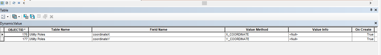
I looked at your DynamicValues.xlsx. I did see that you had X & Y coordinate which is what I am trying to accomplish for multiple feature classes. I have attached the screenshot of how far I am. I understand that I set up rules, have to have the feature where I want the XY to calculate selected, and be in an edit session. Do you have any suggestions? Do I need to move the selected feature for XY to calculate every time I move it? I am trying to automate XY Coordinate calculation for many features.
- Mark as New
- Bookmark
- Subscribe
- Mute
- Subscribe to RSS Feed
- Permalink
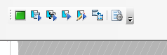
You click use the toolbar to trigger the rule
- Mark as New
- Bookmark
- Subscribe
- Mute
- Subscribe to RSS Feed
- Permalink
Based on the picture you showed, when you create the feature, as long as the attribute assistant is on, it will populate the X&Y. If you want it to update every time you move the feature, you must set the change geometry to true (1) as well. If you want to recalculate selected features, as Michael Miller said, you click the 'On_Manual' icon tool from the AA toolbar and it will execute all commands from the dynamic table set to true on On_Manual. Make sure you have set the On_Manual to true on the commands you want to run and off on the ones you do not want. Every time you run the ON_Manual for X&Y, everything else set to True (1) on On _Manual will be running as well.
- Mark as New
- Bookmark
- Subscribe
- Mute
- Subscribe to RSS Feed
- Permalink
Does it help to keep the DynamicValue Table in the same GDB?
- Mark as New
- Bookmark
- Subscribe
- Mute
- Subscribe to RSS Feed
- Permalink
Does not matter, needs to be in the map. If you are editing it and the data, it helps so you do not have to switch edit sessions