- Home
- :
- All Communities
- :
- Products
- :
- Data Management
- :
- Data Management Questions
- :
- Project for a class
- Subscribe to RSS Feed
- Mark Topic as New
- Mark Topic as Read
- Float this Topic for Current User
- Bookmark
- Subscribe
- Mute
- Printer Friendly Page
Project for a class
- Mark as New
- Bookmark
- Subscribe
- Mute
- Subscribe to RSS Feed
- Permalink
Hi, I am in a class that uses ARC GIS 10.2.2. Until now, my professor has always given us the data that we needed for projects. However, I have my own data in an Excel and I want to put it in ARC GIS. I have no idea how to create an attribute table, or if it would be easier to include the Microsoft Excel document.
Can someone tell me how to do either or both of those?
Thanks,
Chase
- Mark as New
- Bookmark
- Subscribe
- Mute
- Subscribe to RSS Feed
- Permalink
I am doing a research project looking at the Alumni in my school by state. So, for right now, all that I have is state names and numbers. No lat, long information.
- Mark as New
- Bookmark
- Subscribe
- Mute
- Subscribe to RSS Feed
- Permalink
What have you tried so far? And, have you tried searching for something like "arcgis excel to shapefile"?
- Mark as New
- Bookmark
- Subscribe
- Mute
- Subscribe to RSS Feed
- Permalink
Greetings,
You can bring the excel file into ArcMap as a table. If you want to visualize it you could try to join the table with the state feature based on name. To create an attribute table you can export the excel table in ArcMap.
Hope this helps.
- Mark as New
- Bookmark
- Subscribe
- Mute
- Subscribe to RSS Feed
- Permalink
Sounds to me like your professor didn't cover the basics of GIS before turning you loose on this assignment. But... Maybe that's the madness to his/her madness. Here's an option; try looking here:
or here:
ArcGIS Help (10.2, 10.2.1, and 10.2.2)
This should make it more of a learning experience...
- Mark as New
- Bookmark
- Subscribe
- Mute
- Subscribe to RSS Feed
- Permalink
Hi Chase,
You could try this
1) Save the excel sheet as a CSV file.
2) Go to www.arcgis.com, login with your Esri Global account.
3) Go to Map. Drag the CSV file from Windows Explorer and drop it on the Map Viewer of ArcGIS.com.
4) A new dialog box will open. click the radio button next to address.. And also change the location field. Then Add Layer.
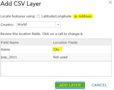
The points should get displayed
Save and share the map with everyone, if required.
Think Location
- Mark as New
- Bookmark
- Subscribe
- Mute
- Subscribe to RSS Feed
- Permalink
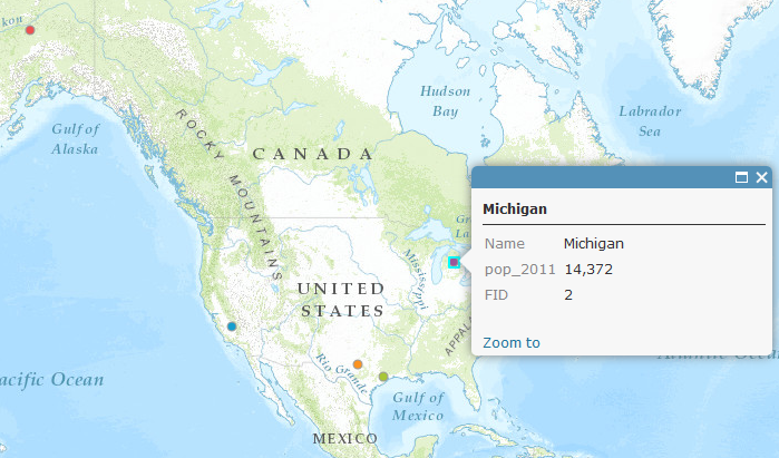
This is what I got when I successfully managed to get the information from Excel to ARC GIS. How do I fix this?
- Mark as New
- Bookmark
- Subscribe
- Mute
- Subscribe to RSS Feed
- Permalink
Chase Bergklint:
This is what I got when I successfully managed to get the information from Excel to ARC GIS. How do I fix this?
What format did you "successfully" create in ArcGIS (assuming arcmap)? Is it just the table/ or where you trying to create an event (in which case you would need coordinates like x/y or long/lat).
What you have displayed "looks" like a projection issue where you might have the long/lat x/y reversed, or telling ArcMap that is is a different coordinate system coming in.
If you only have a state name...find a layer that has state shape file already, then follow the advice of other below and join the created table to the shapes. Use the online help as Joe pointed out, to search for different concepts.
- Mark as New
- Bookmark
- Subscribe
- Mute
- Subscribe to RSS Feed
- Permalink
Chase,
Are you able to attach your file for community review?