- Home
- :
- All Communities
- :
- Products
- :
- ArcGIS GeoEvent Server
- :
- ArcGIS GeoEvent Server Questions
- :
- Example of working Stream Service with Related Fea...
- Subscribe to RSS Feed
- Mark Topic as New
- Mark Topic as Read
- Float this Topic for Current User
- Bookmark
- Subscribe
- Mute
- Printer Friendly Page
Example of working Stream Service with Related Features
- Mark as New
- Bookmark
- Subscribe
- Mute
- Subscribe to RSS Feed
- Permalink
I am having trouble correctly configuring a Stream Service with related features (related feature service) enabled. I'm looking for a publicly accessable example of a working Stream Service without geometry, where the geometry gets joined through the related feature service.
Thank you!
- Mark as New
- Bookmark
- Subscribe
- Mute
- Subscribe to RSS Feed
- Permalink
Can you provide more information about your problem? I understand the Stream Service is an output connector with a few configuration parameters; and the URL to the Stream Service needs to published to your ArcGIS server as a Stream Server, so that it shows up as an URL like your map services. You can access the output from the Stream Server URL the same way you use the other map service URLs.
I have a working Stream Service URL but I'm using the javascript api to consume the stream server url.
- Mark as New
- Bookmark
- Subscribe
- Mute
- Subscribe to RSS Feed
- Permalink
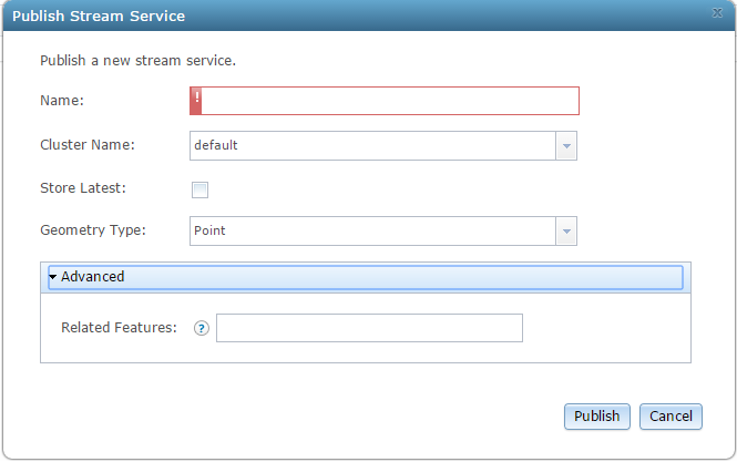
When you Publish a Stream Service there is the option of including a URL to a Feature Layer as Related Features.
From all the information I got this option allows you to stream data through a Stream Service that does not include geometry. The client (javascript) will join the features using the TrackId field between data coming from the websocket (Stream Service) and features in the Related Feature Layer.
I'm trying to get this to work, but I haven't had any success. I'm looking for a working example of this setup, so that I can use that as a reference. That is, make sure I've configured everything correctly.
- Mark as New
- Bookmark
- Subscribe
- Mute
- Subscribe to RSS Feed
- Permalink
Thanks for the explanation. To accomplish what you need must be performed in the GeoEvent Manager on the Outputs section. By adding an Output connector, you can Publish your Stream Service and configure it. You must click the Publish Stream Service button after providing a Service Name. This will create your stream service url. As long as you provide a URL to the Related Feature as well. Once I Published the Stream Service everything fell into place.
Create your Input Connector and the GeoEvent Processor to assist with what your trying to accomplish. About your screenshot, I can't tell if you're in the GeoEvent Manager or the ArcGIS Manager section.
- Mark as New
- Bookmark
- Subscribe
- Mute
- Subscribe to RSS Feed
- Permalink
Hello Michael -
A stream service output's 'Related Feature' property is a URL which is passed along to clients subscribing to the stream service. GeoEvent does not actually do anything with this URL (other than pass it along to clients). Clicking 'Subscribe' on the stream service's HTML page in the ArcGIS REST Services Directory, for example, will not show you any enrichment. The intent is that a real-time data stream, rich with attributes but missing a Geometry, can link to a related feature service which contains *only* the location (Geometry) for sensors in a network so that the real-time sensor data can be displayed on a web map.
I've attached a PDF with several steps which illustrate how the 'Related Features' capability is supposed to work when using Stream Services. I shared these with you off-forum already ... I'm posting them here for the benefit of the community.
Hope this information helps -
RJ