- Home
- :
- All Communities
- :
- User Groups
- :
- Web AppBuilder Custom Widgets
- :
- Questions
- :
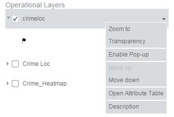
- Enable Pop-up
- Subscribe to RSS Feed
- Mark Topic as New
- Mark Topic as Read
- Float this Topic for Current User
- Bookmark
- Subscribe
- Mute
- Printer Friendly Page
- Mark as New
- Bookmark
- Subscribe
- Mute
- Subscribe to RSS Feed
- Permalink
I am adding a layer when a widget loads.
I am trying to have popups enabled when it loads.
I cannot find the script to enable popup on load.
I hope this is an easy option.
Solved! Go to Solution.
Accepted Solutions
- Mark as New
- Bookmark
- Subscribe
- Mute
- Subscribe to RSS Feed
- Permalink
Rickey,
Try the code below:
// require('jimu/LayerInfos/LayerInfos')
// testCode funciton is in Windget's context;
testCode: function() {
var url = "http://sampleserver6.arcgisonline.com/arcgis/rest" + "/services/CommercialDamageAssessment/FeatureServer/0";
var featureLayer = new FeatureLayer(url);
this.map.addLayer(featureLayer);
featureLayer.on('load', lang.hitch(this, function() {
LayerInfos.getInstance(this.map, this.map.itemInfo).then(lang.hitch(this, function(layerInfos) {
var featureLayerInfo = layerInfos.getLayerInfoById(featureLayer.id);
featureLayerInfo.loadInfoTemplate().then(lang.hitch(this, function() {
featureLayerInfo.enablePopup();
}));
}));
}));
},
LayerInfos is data structure of WAB that reflects the relationships of all operational layers of map. After add a layer to the map, you can get its 'LayerInfo' using layerId by layerInfos.getLayerInfoById(), and then using layerInfo to control popup(loadInfoTempalte and enable popup).
- Mark as New
- Bookmark
- Subscribe
- Mute
- Subscribe to RSS Feed
- Permalink
typically you configure and enable pop ups through AGOL web map. I am assuming you are adding this layer after the map is loaded?
-Stan
- Mark as New
- Bookmark
- Subscribe
- Mute
- Subscribe to RSS Feed
- Permalink
Stan,
Yes I am using same concept as the local layer widget to load the layer.
- Mark as New
- Bookmark
- Subscribe
- Mute
- Subscribe to RSS Feed
- Permalink
Rickey,
Try the code below:
// require('jimu/LayerInfos/LayerInfos')
// testCode funciton is in Windget's context;
testCode: function() {
var url = "http://sampleserver6.arcgisonline.com/arcgis/rest" + "/services/CommercialDamageAssessment/FeatureServer/0";
var featureLayer = new FeatureLayer(url);
this.map.addLayer(featureLayer);
featureLayer.on('load', lang.hitch(this, function() {
LayerInfos.getInstance(this.map, this.map.itemInfo).then(lang.hitch(this, function(layerInfos) {
var featureLayerInfo = layerInfos.getLayerInfoById(featureLayer.id);
featureLayerInfo.loadInfoTemplate().then(lang.hitch(this, function() {
featureLayerInfo.enablePopup();
}));
}));
}));
},
LayerInfos is data structure of WAB that reflects the relationships of all operational layers of map. After add a layer to the map, you can get its 'LayerInfo' using layerId by layerInfos.getLayerInfoById(), and then using layerInfo to control popup(loadInfoTempalte and enable popup).