- Home
- :
- All Communities
- :
- Products
- :
- Data Management
- :
- Data Management Questions
- :
- Project a set of coordinates - points from an exce...
- Subscribe to RSS Feed
- Mark Topic as New
- Mark Topic as Read
- Float this Topic for Current User
- Bookmark
- Subscribe
- Mute
- Printer Friendly Page
Project a set of coordinates - points from an excel into a shape file with unknown coordinate system (map-match)
- Mark as New
- Bookmark
- Subscribe
- Mute
- Subscribe to RSS Feed
- Permalink
Hello,
I am trying to project a set of coordinates (points) from an excel, on top of a shape file (map) with an unknown coordinate system.
The excel file was created by first creating a map with some points in Google earth and then exported it into a .kml file and then created the excel.
The shape file was given to me ready for the project i am doing. Basically i am trying to map-match the two files and then join-relate them to get some additional information for my project.
Here is what i did step by step:
1. Open ArcMap (V.10.1) and right clicked 'Layers' and defined a Geographic Coordinate System 'WGS 1984'
2. Imported the "vista_nicosia_links.shp" (first attachment) and received a warning for unknown Spatial Reference (second attachment:Unknown_Spatial_Reference.jpg)
3. Exported the file into a shape file using 'the same coordinate system as the Data frame' option (third attachment:Export_Output.shp).
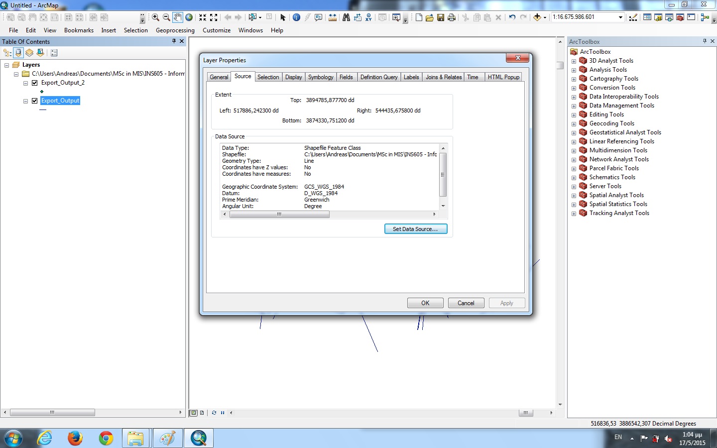
4.Now in the Properties->Source tab i can see the Geogra[hic Coordinate System to be GCS_WGS_1984 and the 'Extend' info are those in the forth attachment(Extend_Export_Output.jpg) having 7 digits on the left of the comma.
5.I closed and re-opened ArcMap and performed actions of Step 1
6. Then i added X,Y data from the excel file (fifth attachment: MAP V_5.3 Coordinates) and then right-click -> display X,Y data and specified the X and Y field. In the description of Input Coordinate System it was by default GCS_WGS_1984.
7.I exported the data into a .shp file (sixth attachment:Export_Output_2.shp) using 'the same coordinate system as the Data frame' option.
8.I re-opened ArcMap and repeated actions in step 1 and imported the two shape files i created in steps 3 and 7(Export_Output.shp and Export_Output_2.shp)
9. The two shape files are displayed in entirely different positions the one far away from the other. I noticed that in right click -> Properties -> Source tab-> 'Extent' area of the Export_Output i see that there are 7 digits on the left of the comma (forth attachment: Extend_Export_Output.jpg), where as in Export_Output_2 i see only 2 digits on the left of the comma (seventh attachment: Extend_Export_Output_2.jpg).
10. Then i tried to project both shape files (one at a time) from "ArcToolbox -> Data Management Tools -> Projections and Transformations -> Define Projection" into Projected Coordinate system 'WGS 1984 World Mercator' but nothing seems to change or happening. They are both re-projected at the same (initial) positions.
I also tried many other alternatives i found in the internet but didn't manage to sort this out.
It would be greatly appreciated if someone could help me to sort this out because i don't know what i am doing wrong and i am stacked at this point for quite a long now.
Solved! Go to Solution.
Accepted Solutions
- Mark as New
- Bookmark
- Subscribe
- Mute
- Subscribe to RSS Feed
- Permalink
If these two shapefiles were supplied from the same source, I would make the assumption that the undefined shapefile has been created in the same projection as the other one. Load the other one into a new map project first. then bring in the undefined one, and see if it lines up as expected. If so, the use the define projection tool to assign that UTM projection to it. After you've done that, you can use the Project tool to change the projection to Geographic coordinates with WGS 84.
- Mark as New
- Bookmark
- Subscribe
- Mute
- Subscribe to RSS Feed
- Permalink
It's clear from your screenshot and description of the extent on export_output that your original shapefile was NOT in geographic coordinates. Those look like possible UTM coordinates to me. Anyway, you need to find out from who ever gave you the shapefile what projection it is in, or you can try UTM for the correct zone for your area, and see if that works. The original projection needs to be defined correctly before you can proceed with reprojecting the data (using the project tool) into geographic coordinates to match you excel file.
I downloaded your zip files to examine the data mayself, and try to figure out the correct projection for your shapefile, but unfortunately you didn't include all of the different files associated with your shapefiles, only the .shp file. You need to include all the files that have the name of the shapefile (6-8 files usually) to make it useable in ArcMap.
One more comment on your steps: why do you keep closing and reopening ArcMap? I'm not sure why you feel this step is necessary.
- Mark as New
- Bookmark
- Subscribe
- Mute
- Subscribe to RSS Feed
- Permalink
First of all i would like to thank you both for replying to this post.
My original shape file indeed had no coordinate system defined. I attach two .rar files with all related shape files i was given. The shape file in 'NICOSIAVISUM_BMODEL2010_countlocation.rar' (which includes 7 files related to the .shp file as you said) has a defined coordinate system WGS 1984 UTM, Zone 36 North. When i add the shape file of the second attachment 'vista_nicosia_nodes.rar' (there are only 3 files related to the vista_nicosia_links.shp and not 6-8 as you said) i receive a warning for unknown Spatial Reference (my second attachment of the problem i described - Unknown_Spatial_Reference.jpg) which also says that it can be drawn but cannot be projected. These are all the related data i have in shape files format.
The coordinate system i want to work is WGS 1984. So what steps should i follow to project the vista_nicosia_links.shp in this coordinate system and then add the point coordinates from my excel file? Also if the vista_nicosia_links.shp is projected in WGS 1984, should i see coordinates with two decimals on the left like my coordinates in the excel or it is not related (i mean could the one have 7 decimals on the left and the other 2 and be projected the one over the other)?
Sorry if my questions sound silly but i am fairly new to this field.
Thanks again for your help
P.S. : For the closing and reopening of ArcMap i just did it because i was not sure if the Coordinate system i set in 'Layers' could affect the other files i imported. Since you say it is not necessary i will avoid it.
- Mark as New
- Bookmark
- Subscribe
- Mute
- Subscribe to RSS Feed
- Permalink
If these two shapefiles were supplied from the same source, I would make the assumption that the undefined shapefile has been created in the same projection as the other one. Load the other one into a new map project first. then bring in the undefined one, and see if it lines up as expected. If so, the use the define projection tool to assign that UTM projection to it. After you've done that, you can use the Project tool to change the projection to Geographic coordinates with WGS 84.
- Mark as New
- Bookmark
- Subscribe
- Mute
- Subscribe to RSS Feed
- Permalink
In the meantime, I will play with your shapefiles.
- Mark as New
- Bookmark
- Subscribe
- Mute
- Subscribe to RSS Feed
- Permalink
Yep, I downloaded your files, extracted them, and loaded the UTM one into a new project. Then I brought in the undefined one, and it lined up perfectly, meaning that it has the same coordinate system. I used the Define Projection tool, and selected the UTM projection from the first shapefile. After that, I used the Project tool to change it to Geographic coordinates-->World-->WGS 84. Voila!
- Mark as New
- Bookmark
- Subscribe
- Mute
- Subscribe to RSS Feed
- Permalink
A word of advise though, depending on what analyses you have planned for this data, it might be a better idea to leave your shapefiles in the UTM projection, and then after you have converted your Excel data to a shapefile with geographic coordinates, change the projection of that shapefile to UTM (using the Project tool, not the Define Projection tool, of course).
- Mark as New
- Bookmark
- Subscribe
- Mute
- Subscribe to RSS Feed
- Permalink
Ok i did that and it lines up! I also did the define projections so now the vista_nicosia_links has a projected coordinate System WGS 1984 UTM, Zone 36 North. But now when i try to add my x,y datai receive the attached Drawing Error. I exported the x,y into a shape file and even though it has the correct projected coordinate system (as the other shape files), the points are still projected elsewhere...
- Mark as New
- Bookmark
- Subscribe
- Mute
- Subscribe to RSS Feed
- Permalink
Your XY data is in geographic coordinates, or lat/long in decimal degrees. Load the original table from excel. Go through the steps you did previously--right click, display x/y data, make sure the correct fields are chosen, and be sure the coordinate system is set as:
Geographic Coordinate System:
Name: GCS_WGS_1984
If it is not, change it to that before clicking ok. Once you have done that, you can use the Project tool to change it to the same UTM projection as the shapefiles.
To reiterate: you must have your data projection or coordinate system defined correctly IN THE ORIGINAL PROJECTION THE DATA WAS CREATED IN, before you can change it to something new using the Project tool.
- Mark as New
- Bookmark
- Subscribe
- Mute
- Subscribe to RSS Feed
- Permalink
To answer in more depth your question about WGS 84, and decimal points, etc. WGS 84 is actually a datum, not a projection, and can be applied to UTM or geographic coordinates (notice the UTM projection says WGS 84 at the beginning. What you have going on here is two different coordinate systems, which can be called projections for ArcMap purposes. The numbers with two numbers before the decimal point are Geographic coordinates, or lat/long in decimal degrees, as you see in your excel table. The other numbers are UTM coordinates in meters. You might want to google these two and do a little reading on them. Bottom line is, ArcMap will read these sets of coordinates in whatever coordinate system you specify, but if you tell it the wrong one, your data will end up in the wrong place.