- Home
- :
- All Communities
- :
- Products
- :
- ArcGIS Spatial Analyst
- :
- ArcGIS Spatial Analyst Questions
- :
- How do you aggregate multiple least cost pathways ...
- Subscribe to RSS Feed
- Mark Topic as New
- Mark Topic as Read
- Float this Topic for Current User
- Bookmark
- Subscribe
- Mute
- Printer Friendly Page
How do you aggregate multiple least cost pathways into one raster, while retaining the number of pathways crossing any one location?
- Mark as New
- Bookmark
- Subscribe
- Mute
- Subscribe to RSS Feed
- Permalink
- Report Inappropriate Content
Hi there,
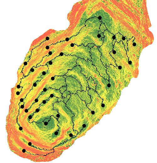
I have 44 different points - each is a center point of an archaeological terrace. My end goal is to create a network of least cost paths (LCPs) over a slope raster (cost surface) from all 44 points to all 44 points. In doing so I want to isolate "highways" or "bottlenecks" where multiple LCPs converge along the same path. At the same time I want to calculate the number of pathways that any one "highway" is made up of. I don't mind whether the end result is a collection of line objects or raster pixels that represent lines.
So far, I have created a model in model builder that iterates the LCP analysis steps for each individual point as a single shapefile source to the 44 points within a separate single shapefile. As you would expect, the result is 44 different rasters with no information of how many LCPs contribute to the represented lines in the raster (see the attached figure 1 as an example of LCPS from one source to all other 43 points, and figure 2 showing all overlapping LCP layers between all points. The background raster is the slope cost surface. Please ignore the colour variation in the LCP pixels).
Would the best way be to carry out single LCPS between all points, add an attribute value of "1" to each path pixel and then simply add the many, many rasters together in raster calculator to represent the number of pathways that overlap in each pixel? I have no experience with python scripting, but I fear that this would be the only plausible option of tackling this problem. Any suggestions would be much appreciated.
Kind regards and thank you for your time,
Tamarama
- Mark as New
- Bookmark
- Subscribe
- Mute
- Subscribe to RSS Feed
- Permalink
- Report Inappropriate Content
A few of the LCPs in the previously attached "figure 2" are erroneous. Please find attached a clean version of LCPs between all 44 points.
Regards,
Tamarama