- Home
- :
- All Communities
- :
- Developers
- :
- Python
- :
- Python Questions
- :
- Using Drawing Tools in Python
- Subscribe to RSS Feed
- Mark Topic as New
- Mark Topic as Read
- Float this Topic for Current User
- Bookmark
- Subscribe
- Mute
- Printer Friendly Page
Using Drawing Tools in Python
- Mark as New
- Bookmark
- Subscribe
- Mute
- Subscribe to RSS Feed
- Permalink
I am trying to make a user friendly interface needing to capture an area of interest boundary to use in selecting layer records to be processed with Python. I would like to imitate the interactive GUI capability of simply drawing a graphic rectangle on the map and use the "select by graphic" to select the layer records to process. Is there a way to access these functions or is there a way to emulate this simple user interface in Python?
- Mark as New
- Bookmark
- Subscribe
- Mute
- Subscribe to RSS Feed
- Permalink
Hi David,
Take a look at the python add-in example here. You will just need to update the code slightly to perform a 'Select by Location'.
- Mark as New
- Bookmark
- Subscribe
- Mute
- Subscribe to RSS Feed
- Permalink
Jake,
Thank you for the information.
Is this only available with the Addin? I am developing a Script tool specifically. I am new to Python and have been working with ESRI Tech Support for assistance and was lead in the direction of developing a Script tool as being a bit less complicated to create.
- Mark as New
- Bookmark
- Subscribe
- Mute
- Subscribe to RSS Feed
- Permalink
Yes, you can do this by using the following code:
import arcpy

graphic = arcpy.GetParameterAsText(0)

arcpy.MakeFeatureLayer_management(graphic, "lyr")
arcpy.SelectLayerByLocation_management(arcpy.GetParameterAsText(1), "INTERSECT", "lyr")
arcpy.RefreshActiveView()
You will then want to add this script to a toolbox. See the section 'Adding Script Tools' here. After you add the script, right-click on the Script tool > Properties > Parameters tab. You will want to set up two parameters:
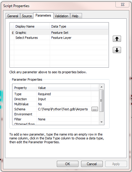
For the first parameter, select a polygon feature class for the 'Schema' in the Parameter Properties. The tool should then be ready to use.
- Mark as New
- Bookmark
- Subscribe
- Mute
- Subscribe to RSS Feed
- Permalink
Hi Jake,
Thank you for providing information and education.
That is the point where I currently am at with my Script tool. You have to define the schema to use which is the polygon editing. The user interaction at this point is a polygon editing tool. If you use the "rectangle" default the user interface is to make 3 clicks, not like the simple graphic rectangle draw click and drag a rectangle - very user friendly.
This is the meat of my inquiry. A user needs a little education on how to "digitize" a rectangle. The graphic rectangle is so intuitive and user friendly needing no education. I would like to improve the user experience to make it as simple as the interactive graphic draw capability (if it were open to Python to use).
- Mark as New
- Bookmark
- Subscribe
- Mute
- Subscribe to RSS Feed
- Permalink
I don't believe you can set the default tool for a script tool. However, you can use a rectangle for the shape property of a python add-in tool. Developing a python add-in will be a little more complex, but it will accomplish the user experience you are looking for.
- Mark as New
- Bookmark
- Subscribe
- Mute
- Subscribe to RSS Feed
- Permalink
Thank you Jake,
It would be so much easier if Python had access to the "Graphic Draw tools" and the "Select by Graphic" in the interactive user interface.