- Home
- :
- All Communities
- :
- Products
- :
- 3D
- :
- 3D Questions
- :
- Polyline Z to Buffer with same Z dimensions??
- Subscribe to RSS Feed
- Mark Topic as New
- Mark Topic as Read
- Float this Topic for Current User
- Bookmark
- Subscribe
- Mute
- Printer Friendly Page
Polyline Z to Buffer with same Z dimensions??
- Mark as New
- Bookmark
- Subscribe
- Mute
- Subscribe to RSS Feed
- Permalink
Does anyone know how I might be able to take a polyine z and create a planar buffer that extends horizontally, but retains the same vertical contour as the polyline? Buffer 3D seems to only create a tubular buffer around the line and the buffer tool in analysis creates a planar buffer, but it is not a polygon z and therefore does not retain the same shape as the polyline z. Any suggestions?
Solved! Go to Solution.
Accepted Solutions
- Mark as New
- Bookmark
- Subscribe
- Mute
- Subscribe to RSS Feed
- Permalink
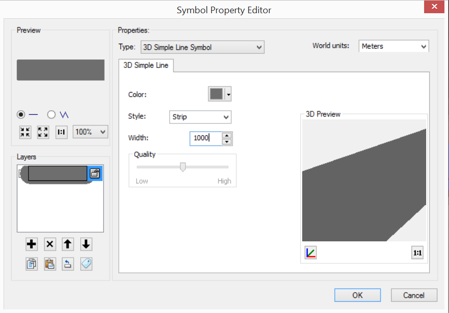
I figured out a way that works! So, the only way that I was able to complete this task (without a crazy amount of manual editing) was to load my line features into ArcScene and change the symbology of the line to a 3D simple line symbol with type "Strip" (for some reason this same process doesn't work in ArcMap itself because there is a limit of 100m width for lines). This makes it so that the line is extended to whatever distance you specify on the sides, but does not create a tube. It creates a flat plane that follows the same contour as your 3D line. Here is a picture of the settings for changing the symbology:
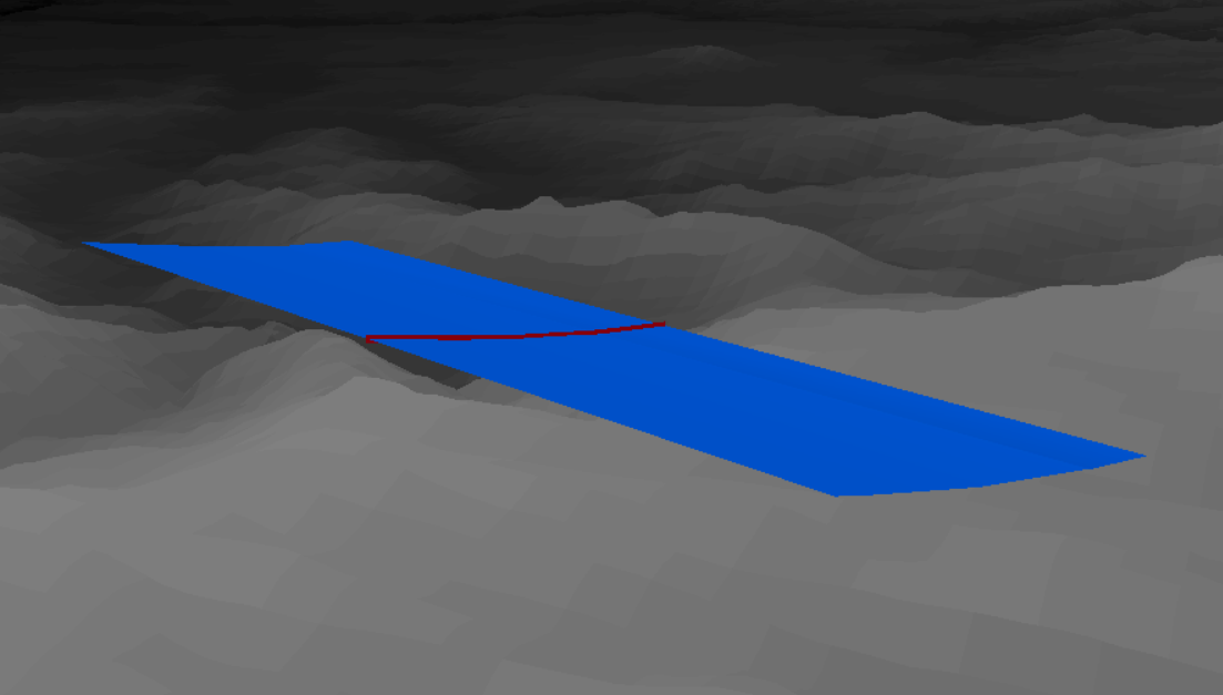
Once you have changed the symbology, then (still in ArcScene) you can use the "Layer 3D to Feature Class" tool and it will retain the symbology in a multipatch feature class. Below is a picture of the Multipatch feature class:
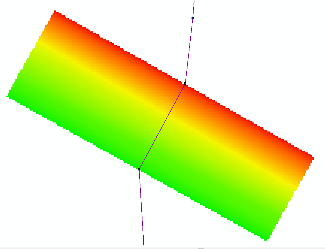
Then, since I needed a raster I loaded the multipatch back into ArcMap and used the tool "Multipatch to Raster". A picture of the raster is below:
I couldn't find any information on how to accomplish this so I hope this helps anyone else who might have the same problem!
- Mark as New
- Bookmark
- Subscribe
- Mute
- Subscribe to RSS Feed
- Permalink
If i'm not wrong, yes, it is possible, you just have to choose in the options while creating the buffer that you only want it in a specific direction
- Mark as New
- Bookmark
- Subscribe
- Mute
- Subscribe to RSS Feed
- Permalink
Regards,
Raymond
- Mark as New
- Bookmark
- Subscribe
- Mute
- Subscribe to RSS Feed
- Permalink
Sorry, you're right. That wasn't very clear in my question. I am trying to create a 2D buffer that extends from a polyline that is in 3D space. So , I do not want a buffer that has a volume, I just need one that follows the same shape as my polyline. In this specific example I have a polyline that represents a power line in 3D space and I need to create a planar buffer that has the same shape and height as the power line. The issue is that power lines sag, so they are not straight lines, but when you use the 2D buffer function it does not retain that 'sag' in the buffer. I hope that makes it more clear!
- Mark as New
- Bookmark
- Subscribe
- Mute
- Subscribe to RSS Feed
- Permalink
- Mark as New
- Bookmark
- Subscribe
- Mute
- Subscribe to RSS Feed
- Permalink
I am trying to use this buffer to create a raster surface with power line height so that I can automate the process of subtracting vegetation height from power line height at different buffer distances. We are trying to figure out how vegetation heights around power lines at different distances away from the power lines affect seabird flight.
- Mark as New
- Bookmark
- Subscribe
- Mute
- Subscribe to RSS Feed
- Permalink
I see. I believe it is more tedious to achieve this in vector. How about try doing it in raster form then?
I can imagine the workflow to be such:
From your line with elevation, create a raster presenting your line with its elevation as the raster value.
Then use the Expand tool to expand your raster representing the line by the number of required cells calculated by the distance required divided by the cell size. This essentially creates a ‘buffer’ for you in raster form with the necessary elevation values in each cell.
Let me know if this workflow works for you.
- Mark as New
- Bookmark
- Subscribe
- Mute
- Subscribe to RSS Feed
- Permalink
I tried this method and I thought it was going to work really well, BUT since the line itself is sloping and not a constant value there is no way to assign a value from the attribute table to the raster so that the raster retains that slope of the line (at least not that I could figure out). The resulting raster only had two values containing what I believe is the average elevation of the power line.
The only way that I have been able to work this out is to take my points derived from LiDAR that contain the elevation of each point and copy them and move them to the required distance away from the original points then create a TIN that connects the original points to the copied points. This creates a sloping TIN that follows the power lines. From that TIN, I can then create a raster with the elevation value that is representative of the shape of the line. The raster is the end result that I wanted, so that is why I was really hoping the method you presented would work. Let me know if you know of a way to make the raster follow the slope of the line rather than be represented as one elevation. Thanks for your input!
- Mark as New
- Bookmark
- Subscribe
- Mute
- Subscribe to RSS Feed
- Permalink
Esteban, buffering in a specific direction is possible, yes, and I know how to perform that task. Refer to my reply to Raymond for a more detailed explanation of my question. Thanks!
- Mark as New
- Bookmark
- Subscribe
- Mute
- Subscribe to RSS Feed
- Permalink
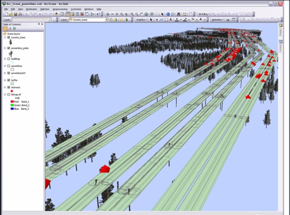
Esteban Herrera and Raymond Huang
If you are still interested in this discussion then you should take a look at this picture. I was watching a video for power line corridor mapping and hazard tree detection (Resource Management & Power Line Encroachment Applications: E3De LiDAR Exploitation - YouTube) and at the end of the video they just mention: "and then you can create a buffer in arcscene and use the intersect tool to see where the trees are taller than the power lines". They make it seem like this is a well known function, but I can't find any tool that allows me to create a buffer like that (i.e. one that has the same z dimensions as the 3D line, but is a flat surface). Anyway, maybe this visualization will spark some inspiration and help get what I need to do across a little better.