- Home
- :
- All Communities
- :
- Products
- :
- Spatial Statistics
- :
- Spatial Statistics Questions
- :
- Labelling polygons by intersecting data of MAX cov...
- Subscribe to RSS Feed
- Mark Topic as New
- Mark Topic as Read
- Float this Topic for Current User
- Bookmark
- Subscribe
- Mute
- Printer Friendly Page
Labelling polygons by intersecting data of MAX coverage
- Mark as New
- Bookmark
- Subscribe
- Mute
- Subscribe to RSS Feed
- Permalink
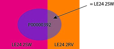
How do you attribute a polygon record with the field ID of the intersecting polygon of greatest coverage?
e.g. below area P00000392 intersects both Areas LE24 2SW and LE24 2RV, but I want P00000392 to be attributed with LE24 2SW (the largest area).
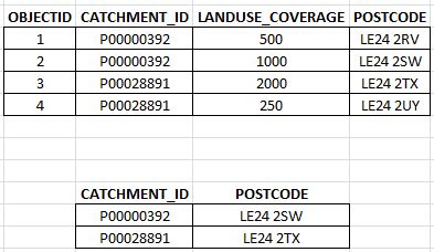
I've got as far as listing the area coverage by polygon, but I'm struggling to know what to do next. Any advice on this would be much appreciated.
I'm currently running a Pivot Table process as I type, but I'm not even sure this will do what I need. I'll let you know if I find a way through this.
- Mark as New
- Bookmark
- Subscribe
- Mute
- Subscribe to RSS Feed
- Permalink
Ah, I've worked it out.
I used Summary Statistics in the end.
Input Table: is the table as shown above.
Statistics Field(s): Field 'LANDUSE_COVERAGE'; Statistics Type: MAX
Case field (optional): CATCHMENT_ID
Then join 'POSTCODE' field to the new output table via 'MAX_Shape_Area' field.
NOTE: the data files need to be created outside a geodatabase folder for the join to work properly.
Sorted. 