- Home
- :
- All Communities
- :
- User Groups
- :
- Coordinate Reference Systems
- :
- Questions
- :
- ArcGIS WGS84 Web Mercator Vs. WGS84 UTM zone 15N: ...
- Subscribe to RSS Feed
- Mark Topic as New
- Mark Topic as Read
- Float this Topic for Current User
- Bookmark
- Subscribe
- Mute
- Printer Friendly Page
ArcGIS WGS84 Web Mercator Vs. WGS84 UTM zone 15N: Very different distance dimensions
- Mark as New
- Bookmark
- Subscribe
- Mute
- Subscribe to RSS Feed
- Permalink
Hi all, I am working in ArgGIS with a field (raster layer in tif format) in which I have placed two points (.shp layer).
I have two versions of both layers, resulting four layers: one tif+shp set in CRS WGS84 Web Mercator and the other tif+shp set in CRS WGS84 UTM zone 15N.
If I establish the CRS of the Data Frame to WGS84 Web Mercator, the distance between the two points is 138 meters, but if I establish the CRS of the Data Frame to WGS84 UTM zone 15N the distance is 99 meters, which is a huge difference. However, the point layers are displayed absolutely one above the other, I mean: the two points in one CRS haven’t any displacement in relation to the other two points; and the same for the rasters.
- Why don’t I see both pairs of points misplaced? Is that “on the fly” projection by ArcGIS? If it’s so, does it mean that ArcGIS projects “on the fly” even between data with CRSs of different geographic coordinate system? (as far as I am concerned, ArcGIS only projects “on the fly” between data with CRSs with the same geographic coordinate system but different projection). NOTE: Both projected CRSs (WGS84 Web Mercator & WGS84 UTM zone 15N) correspond to these two different geographic coordinate systems: in ArcGIS, Geographic Coordinate System > Spheroid-based > WGS 1984 Major Auxiliary Sphere & Geographic Coordinate System > World > WGS 1984, respectively.
Another major doubt is which of the two CRSs is then better for working in the south of Minnesota State (US).
Thank you for any help or idea given.
- Mark as New
- Bookmark
- Subscribe
- Mute
- Subscribe to RSS Feed
- Permalink
Charly, I sometimes experience the same thing. What I think going on is that when using Web Mercator projection it gets really distorted closer to the poles (north, and south), and its also projecting the entire planet. With the UTM Zone, things will be very accurate or it supposed to be accurate for that particular zone, in your case UTM Zone 15N. I think it projecting particular zone vs. entire planet. So I would use UTM Zone for a better accurate measurement.
I also noticed that in ArcMap, not only distance are off, but area as well (square mile, acres, etcs.). Its different when measuring for area using WGS84 Web Mercator vs. UTM zone or StatePlane. I'm guessing ArcMap doesn't read geodesic spherical well?
- Mark as New
- Bookmark
- Subscribe
- Mute
- Subscribe to RSS Feed
- Permalink
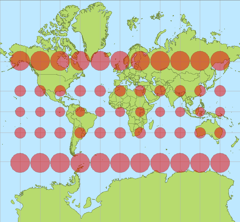
Like any projection, Web Mercator has inherent limitations. First, you will notice that no data is cached at the North or South Pole. This is a limitation of all Mercator projections. Also, area and distance measurements will not be correct since the farther north you take the measurement, the more distortion there is.
An example is in the picture below, a tissot indicatrix, showing the distortion in projected area.
- Mark as New
- Bookmark
- Subscribe
- Mute
- Subscribe to RSS Feed
- Permalink
To expand on Arnold's reply, Web Mercator is designed for viewing and ease in creating/storing/retrieving cached imagery tiles. It's not designed for calculating distances or areas (if you get correct answers, then the software is calculating in something else!).
The fact that the points all lie on top of each other is due to the project on-the-fly capabilities of ArcMap. Whichever coordinate system (CS) the data frame (map) is using, any layers in a different coordinate system are being converted in the data frame's CS. (1)
You have a weird case, in that WGS 1984 Major Auxiliary Sphere isn't a "real" geodetic GCS (datum). Coordinates are the same as in WGS 1984, but are treated as if they're on a sphere with radius 6378137.0 m. If there were two or more geodetic datums involved, you would need to pick transformations. However, ArcMap will still project on-the-fly even if you don't set any transformations. Basically, it just skips the transformation step.
Notice how the longitude lines are parallel in Web Mercator. As a rough guide, that means that the true east-west distance is about cos(latitude) of what's reported. This fits well with what you're seeing: 99/138 = 0.717, cos(44) = 0.719.
You're much better off using the UTM zone, or possibly switching to the SPCS zone (although that's not on WGS84).
Melita
(1) If you want to see what the data looks like with project on-the-fly turned off, click the globe on the Coordinate Systems tab of data frame properties and select the Clear option.
- Mark as New
- Bookmark
- Subscribe
- Mute
- Subscribe to RSS Feed
- Permalink
Thanks Melita,
Do you happen to know why ArcGIS online basemap on a flexviewer application or javascript measure distance and area correctly? vs. when bringing the basemap into ArcMap. I'm still confuse as how that happens, it seems to measure correctly on a web browser vs. in ArcMap(unless you change the projection).
- Mark as New
- Bookmark
- Subscribe
- Mute
- Subscribe to RSS Feed
- Permalink
They're returning the geodesic distance rather than the planar distance. The geodesic distance is the shortest distance between two points on the GCS ellipsoid surface. You can get the geodesic distance in ArcMap too. The Measure Tools supports it. I think it defaults to the planar distance if the data frame's coordinate system is a projected coordinate system. In the measure tool, it's an option on the far right of the tool.
- Mark as New
- Bookmark
- Subscribe
- Mute
- Subscribe to RSS Feed
- Permalink
I get the straight measurement distance, but what about area measurement (sq. km, acres)?
Take Lake Maurepas for example in South Louisiana, it is about 240 sq. km. But when bringing ArcGIS basemap into ArcMap with its native projection of WGS84 web Mercator auxillary sphere, the measurement come out over 310 sq. km.
But when changing the projection in the Data Frame into a UTM Zone 15N or a StatePlane, it come out to be about 240 sq. km. It also correctly show about 240 sq. km. for the lake on the Web browser when measured. I'm still a little confuse that in ArcMap it shows differently unless you change the projection. TIA
- Mark as New
- Bookmark
- Subscribe
- Mute
- Subscribe to RSS Feed
- Permalink
ArcMap hasn't been updated to report geodesic-based areas yet, so to get an equivalent area calculation, you have to switch to a coordinate system that has less area distortion.
- Mark as New
- Bookmark
- Subscribe
- Mute
- Subscribe to RSS Feed
- Permalink
Melita,
So somehow measuring area in a web browser on ArcGIS online basemap is correct. Do you know or can you elaborate on that a little more? What the web browser have that ArcMap doesn't have on the desktop? They are both WGS84 Web Mercator auxillary sphere. Does the web browser automatically transform into another projecton on the fly?
- Mark as New
- Bookmark
- Subscribe
- Mute
- Subscribe to RSS Feed
- Permalink
Different teams manage the various APIs, Server, Desktop, etc. so each software can be at an different stage for implementing functionality. The Geometry Runtime library added support for calculating geodesic-based areas before the geometry library used in ArcGIS for Desktop did. The algorithm is internally converting to an equal area projection. We found that was more stable and flexible for different sized polygons than various algorithms that calculated geodesic-based areas directly.