- Home
- :
- All Communities
- :
- Developers
- :
- Python
- :
- Python Questions
- :
- Can I detect if pyramids have been created for a r...
- Subscribe to RSS Feed
- Mark Topic as New
- Mark Topic as Read
- Float this Topic for Current User
- Bookmark
- Subscribe
- Mute
- Printer Friendly Page
Can I detect if pyramids have been created for a raster in Arcpy?
- Mark as New
- Bookmark
- Subscribe
- Mute
- Subscribe to RSS Feed
- Permalink
I'm writing a tool in Python that looks through rasters stored in a workspace and notes down certain details about them. The results are stored in a feature class. One of the things I'm trying to determine about the rasters is if pyramids have been made for each of them. The only way I can find so far is to look for a .rrd file with the raster. But that won't work for any rasters that are stored in a geodatabase. Can someone please tell me if there is some other way in Python to detect if pyramids have been created?
- Mark as New
- Bookmark
- Subscribe
- Mute
- Subscribe to RSS Feed
- Permalink
Apparently you can't unless you can program in a right-click (can't find anything anywhere, except *.ovr files can also be created, but I don't know if you can check for them)
- Mark as New
- Bookmark
- Subscribe
- Mute
- Subscribe to RSS Feed
- Permalink
I am not aware of any way to do this using arcpy but would also be interested to know if this functionality exists.
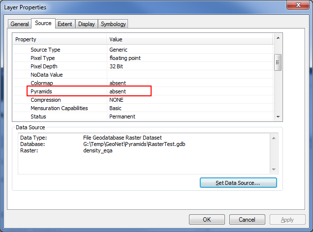
The functionality *should* be part of arcpy describe but it doesn't seem to be exposed. It is obviously there in the underlying ArcObjects as the Layer Properties shows this in the Raster Information section:
Also, note that as of ArcGIS 10 pyramids for file based rasters will be created as OVR files instead of RRD files. However this doesn't help if the raster is in a geodatabase.
Owen