- Home
- :
- All Communities
- :
- Products
- :
- Spatial Statistics
- :
- Spatial Statistics Questions
- :
- How to make spatial correlation in ArcGIS
- Subscribe to RSS Feed
- Mark Topic as New
- Mark Topic as Read
- Float this Topic for Current User
- Bookmark
- Subscribe
- Mute
- Printer Friendly Page
How to make spatial correlation in ArcGIS
- Mark as New
- Bookmark
- Subscribe
- Mute
- Subscribe to RSS Feed
- Permalink
Hi everyone!
I am now having a tough problem that I have any idea how to make a spatial correlation in ArcGIS. I just wonder if anyone could help me or give me some tips if possible. I will explain more details as following.
I have two vector shpfiles, of which these two files are polygon. these polygon represent location of cities and size of cities in same region but different database. It means that these two polygons are somewhat similar.In terms of area of city, I would like to have certain spatial processing which can calculate its spatial correlation (not only size of cities but spatial correlation). I know spatial join function can make some spatial processing but dont know how does this function work with spatial correlation.
In order to have a clear understanding,I will give a details example:
For example, these two layer that I am going to work with are named as Layer A and Layer B.
Layer A is a map of chicago and Layer B is also a map of chicago. However, the city boudary( size of certain polygons) of Layer A is little larger than the city boundary of Layer B(Also, some cities existed in Layer A might not be found in another layer,etc). Supposing if I make a Intersect function, They would have a overlay area that we can have both layers inside. Also, one Big polygon in Layer A might corresponding to two or even more small polygons in Layer B.
I dont have much backround in such work so it would be very helpful if someone can kindly share his/her idea to this. Also,I would very happy if anyone can provide some new prespective.
Thank you for your time
- Mark as New
- Bookmark
- Subscribe
- Mute
- Subscribe to RSS Feed
- Permalink
looks like what you need is union function.
- Mark as New
- Bookmark
- Subscribe
- Mute
- Subscribe to RSS Feed
- Permalink
Hello Riyas
I know that Union function can combine these two polygon files and obtain a new overlay area. But, do you have any idea how can area parameter can be correlated? I want to check thier spatial correlation.
Thank you for your reply.
- Mark as New
- Bookmark
- Subscribe
- Mute
- Subscribe to RSS Feed
- Permalink
what is the output that you are trying to get from these two layers.
1. Copy attribute from one layer to another layer based on spatial relation
2. Calculate attribute for one layer based on how much it overlap another layer
- Mark as New
- Bookmark
- Subscribe
- Mute
- Subscribe to RSS Feed
- Permalink
Like what you said, I want to check how much it overlap each other and how it correlated (etc, one to one or one to many? or many to one?)I want to check how many polygons are matched from layer A to layer B and how.
Here , taking a simply example as following (A1, A2,A3, B1,B2,B3 are polygons)
Layer A (#30000: number of polygon) :
A1
A2
A3
Layer B: (#70000) :
B1
B2
B3
Because Layer A and Layer B are working with same region so that they have almost same city shape but their areas are different. That is, these two layers are somewhat different, which means A1 might not completely corresponding to B1. In this example, B1 might contain the sum of A1, A2, A3..... because layer B has more polygons (please note Layer A and Layer B are in same location).
So, what I am going to do is knowing how do these two layer correlate each other (in terms of its city'area).
- Mark as New
- Bookmark
- Subscribe
- Mute
- Subscribe to RSS Feed
- Permalink
Perform spatial join between layer A and layer B, like below
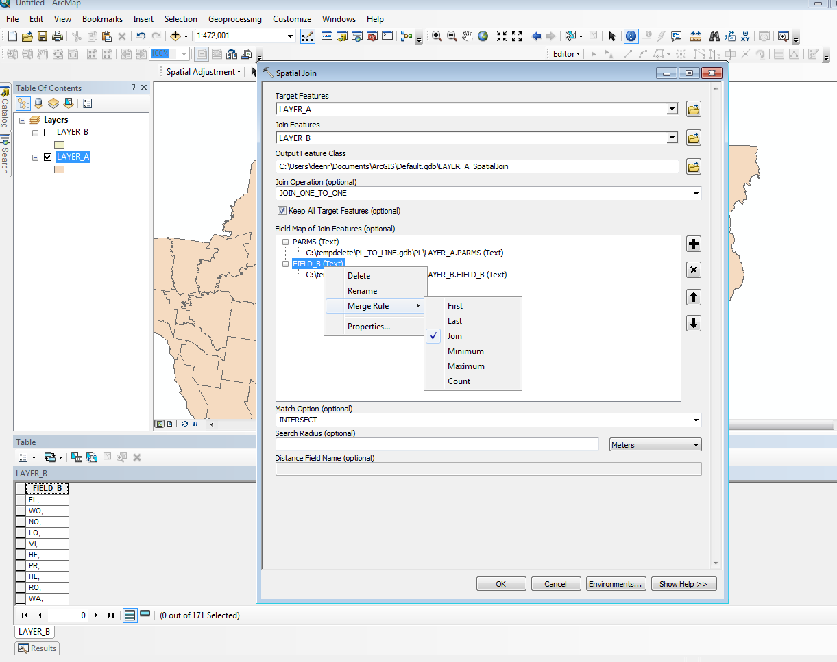
Result below:
Join_Count will tell you correlation between layer 1 and layer 2. if join count is 6 then correlation is 1:6.
FIELD_B is the concatenated ID of layer B features which intersect layer A.

Hope this is what you were looking for
- Mark as New
- Bookmark
- Subscribe
- Mute
- Subscribe to RSS Feed
- Permalink
Hello
Thank you for your good presentation! I think this is a good way. But should I calculate the area of each polygon before working with Spatial join? Because I need compare their area.