Turn on suggestions
Auto-suggest helps you quickly narrow down your search results by suggesting possible matches as you type.
Cancel
- Home
- :
- All Communities
- :
- Products
- :
- ArcGIS Spatial Analyst
- :
- ArcGIS Spatial Analyst Questions
- :
- Surfaces created with spline and IDW do not corres...
Options
- Subscribe to RSS Feed
- Mark Topic as New
- Mark Topic as Read
- Float this Topic for Current User
- Bookmark
- Subscribe
- Mute
- Printer Friendly Page
Surfaces created with spline and IDW do not correspond with input point values
Subscribe
4193
3
01-23-2014 02:18 AM
01-23-2014
02:18 AM
- Mark as New
- Bookmark
- Subscribe
- Mute
- Subscribe to RSS Feed
- Permalink
I'm trying to compare the outputs of interpolated surfaces created using spline and IDW. Textbook definition of the spline method
says that the surface passes exactly through each sample point, whilst IDW will pass through none of the points. I realise that output cell size resolution has an impact on the interpolated surface and I can sort of understand why but I'm not sure why I'm not getting spline values that are exactly the same as the input points.
[ATTACH=CONFIG]30755[/ATTACH]
3 Replies
01-23-2014
06:34 AM
- Mark as New
- Bookmark
- Subscribe
- Mute
- Subscribe to RSS Feed
- Permalink
You will only get the exact value if your input point falls on the same location as the cell center.
Remember that the interpolation technique is making a prediction at the location of the cell center.
From your graphic I don't see that spline prediction = observed value, am I looking in the wrong place?
Regards
Steve
Remember that the interpolation technique is making a prediction at the location of the cell center.
From your graphic I don't see that spline prediction = observed value, am I looking in the wrong place?
Regards
Steve
01-23-2014
11:13 PM
- Mark as New
- Bookmark
- Subscribe
- Mute
- Subscribe to RSS Feed
- Permalink
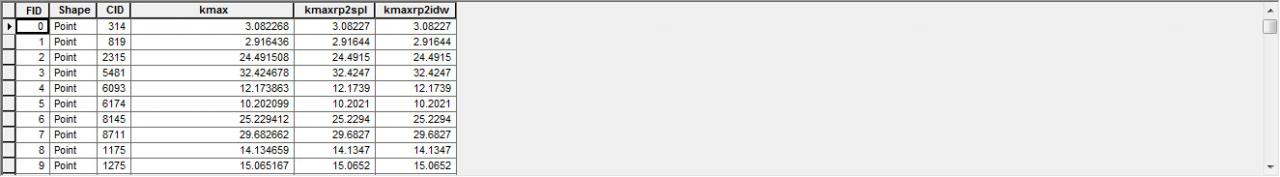
That makes sense - the input point data I used to generate the results above are clustered in two main areas with a couple of outliers at varying distances apart. I used the whole set for the spline and IDW surfaces. I'm assuming that this is why the observed value and the spline interpolation values are all different but get closer to the observed values as the pixel resolution decreases (the original surfaces are calculated with an output pixel resolution of 500, then 250 then 100). However, I have also tested the IDW and spline with points regularly sampled at 200m intervals and then I get exactly the same values for the spline and IDW. I would have thought in this instance that the IDW values would be different.[ATTACH=CONFIG]30796[/ATTACH]
What happens when you have multiple points within a pixel and you are using spline? For example if I have a cell size of 200m and 6 points fall within one pixel. Is the average of the value of the points used as the input to the function?
Thanks Steve for your feedback.
What happens when you have multiple points within a pixel and you are using spline? For example if I have a cell size of 200m and 6 points fall within one pixel. Is the average of the value of the points used as the input to the function?
Thanks Steve for your feedback.
04-09-2014
05:20 PM
- Mark as New
- Bookmark
- Subscribe
- Mute
- Subscribe to RSS Feed
- Permalink
I found the following info in the Spline with Barriers help in case anyone else is interested:
[INDENT][/INDENT]"Some input datasets may have several points with the same x,y coordinates. If the values of the points at the common location are the same, they are considered duplicates and have no affect on the output. If the values are different, they are considered coincident points.
The various interpolation tools may handle this data condition differently. For example, in some cases the first coincident point encountered is used for the calculation; in other cases the last point encountered is used. This may cause some locations in the output raster to have different values than what you might expect. The solution is to prepare your data by removing these coincident points. The Collect Events tool in the Spatial Statistics toolbox is useful for identifying any coincident points in your data.
For the Spline with Barriers tool, by default the values for each set of coincident points will be averaged."