- Home
- :
- All Communities
- :
- User Groups
- :
- Web AppBuilder Custom Widgets
- :
- Questions
- :
- geometryEngine.intersect
- Subscribe to RSS Feed
- Mark Topic as New
- Mark Topic as Read
- Float this Topic for Current User
- Bookmark
- Subscribe
- Mute
- Printer Friendly Page
- Mark as New
- Bookmark
- Subscribe
- Mute
- Subscribe to RSS Feed
- Permalink
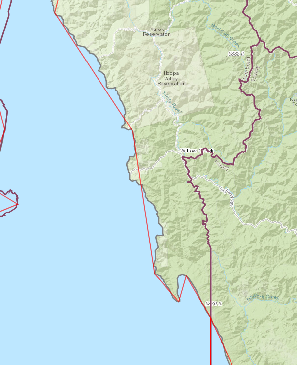
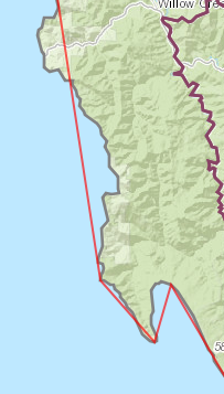
I tested the geometryEngine.intersect with two polygons. One has the purple boundary and the other one has the blue fill. So, when you run the intersect the red line shows the results. If the intersect was working properly, since the blue fill polygon is inside the purple polygon, the intersect (red line) should run along the the contour of the blue fill. It seems that it follows some vertices. This is an issue since the area of the intersect will be miscalculated. Ideas? Thanks.

Solved! Go to Solution.
Accepted Solutions
- Mark as New
- Bookmark
- Subscribe
- Mute
- Subscribe to RSS Feed
- Permalink
Try setting setAutoGeneralize to false
https://developers.arcgis.com/javascript/3/jsapi/featurelayer-amd.html#setautogeneralize
- Mark as New
- Bookmark
- Subscribe
- Mute
- Subscribe to RSS Feed
- Permalink
Lefteris,
How are you getting the geometry objects that you are sending to the intersect method? It seems to me that the features are being generalized before you send them to the Intersect method. The query parameter has a maxAllowableOffset property.
https://developers.arcgis.com/javascript/3/jsapi/query-amd.html#maxallowableoffset
- Mark as New
- Bookmark
- Subscribe
- Mute
- Subscribe to RSS Feed
- Permalink
I have two feature layers with multiple polygon features each. So, I ran each graphic geom from one layer against each graphic geom from the other layer, if it s true that there is intersection, then I store the geom and display it when it's done. How do I define the offset?
var features = [];
var instersect_geom=[];
array.forEach(firstlayer.graphics, function (feature) {
firstgraphics.push(feature.geometry)
})
var secondgraphics = [];
array.forEach(secondlayer.graphics, function (feature1) {
secondgraphics.push(feature1.geometry)
})
console.log(secondgraphics.length);
for (j = 0; j < firstgraphics.length; j++) {
for (i = 0; i < secondgraphics.length; i++) {
if (geometryEngine.intersects(firstgraphics[j], secondgraphics[i], this.map.spatialReference)) {
intersect_geom.push(geometryEngine.intersect(firstgraphics[j], secondgraphics[i], this.map.spatialReference))
count++;
console.log("true")
}
}
}
console.log(count + " " + intersect_geom.length);
for(k=0;k<intersect_geom.length;k++){
var graphic = new esri.Graphic(intersect_geom[k], inter_symbol);
console.log(graphic)
// gra_inter.push(graphic);
theGraphicsLayer.add(graphic);
}
this.map.addLayer(theGraphicsLayer);
},- Mark as New
- Bookmark
- Subscribe
- Mute
- Subscribe to RSS Feed
- Permalink
So firstLayer.graphics or secondLayer.graphics are already generalized before you do the intersection.
You need to set the maxAlowableOffset for those FeatureLayers to 0.
https://developers.arcgis.com/javascript/3/jsapi/featurelayer-amd.html#maxallowableoffset
- Mark as New
- Bookmark
- Subscribe
- Mute
- Subscribe to RSS Feed
- Permalink
Thank you for the suggestion.
I added the maxAlowableOffset property, but it didn't seem to do anything.
firstlayer = new FeatureLayer("http://xxxx/MapServer/3");
firstlayer.maxAllowableOffset=0
secondlayer = new FeatureLayer("http://xxx/0")
secondlayer.maxAllowableOffset=0
- Mark as New
- Bookmark
- Subscribe
- Mute
- Subscribe to RSS Feed
- Permalink
Try setting setAutoGeneralize to false
https://developers.arcgis.com/javascript/3/jsapi/featurelayer-amd.html#setautogeneralize
- Mark as New
- Bookmark
- Subscribe
- Mute
- Subscribe to RSS Feed
- Permalink
Bingo! Thank you.
- Mark as New
- Bookmark
- Subscribe
- Mute
- Subscribe to RSS Feed
- Permalink
I realized that when I run the script from the developer wab on my workstation is very slow to get the results of the intersects but when it's done it displays the intersects correctly. However when I run the script from the website on the server, is very fast but the display is like the autogeneralize is off! There are only 58 features to intersect. Will the geometryservice have a better performance that geometryengine?
- Mark as New
- Bookmark
- Subscribe
- Mute
- Subscribe to RSS Feed
- Permalink
Geometry engine is client side so if should perform faster but it depends on the machine the browser is running on.