- Home
- :
- All Communities
- :
- User Groups
- :
- Web AppBuilder Custom Widgets
- :
- Documents
- :
- Identify Widget Version 2.21 - 11/16/2021
- Subscribe to RSS Feed
- Mark as New
- Mark as Read
- Bookmark
- Subscribe
- Printer Friendly Page
Identify Widget Version 2.21 - 11/16/2021
Identify Widget Version 2.21 - 11/16/2021
Web AppBuilder for ArcGIS | Help - Identify Widget
List of the latest enhancements and changes:
- Added 10 max rows max display to widgets dropdowns.
- Fixed a mixed protocol issue in code
Previous enhancements and changes:
Check the "Older enhancements or changes.txt" in the download for a complete list.
Older Versions
ATTENTION:
- If you are hosting this widget on a https server, then make sure you change all your excludelayer urls to https. Failure to do so will result in widget failure.
Features:
- Specify which layers are to be identified
- Format the fields for identify layers
- Configure links and link icon
- Close result popups after a number of seconds of losing focus
- Choose which layer to identify in the widget UI using drop down list
- Specify layers to be excluded from identify operation
- Choose to only identify configured layers
- Replace null values with empty strings
- Configure default symbology for identify results
- Specify Visible, Top, or All layers to be identified.
- Option to Keep Identify Active
- All Identify geometry types are configurable
- Option to use map time
Kevin,
Yes I am aware of this issue and have it fixed for the next version already.
Hi Robert,
As you are already working on a new widget version, I thought I would ask your opinion about the following issue.
In my viewers, I have a large dynamic layer ("Regional Studies") with includes hundreds of sublayers and sub-sublayers (and even deeper). The layer was added using LocalLayer widget and is turned off by default. All the sublayers are turned off by default in the mxd prior to publishing, but many of the sub-sub layers are on by default.
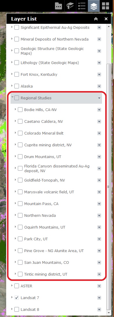
All is good with the ID widget until I turn on the Regional Studies layer, but leave all the sublayers off. Then, when I use the ID widget to click on a feature in an area for which data exists in one or more sub-sublayers of the Regional Studies layer, I get ID results for those data even though the data are not turned on in the Layer List.
Steps to reproduce using this viewer:
1) zoom to Mineral Deposits in Northern Nevada layer.
2) open ID widget and click on something in the map. ID results are normal.
3) Turn on Regional Studies layer.
4) open ID widget and start clicking around on things. Eventually you will see ID results for sublayers in the Regional Studies layer which are invisible as they haven't been turned on the Layer List.
Please let me know if I have not made the above clear enough.
Best regards,
Barnaby
Barnaby,
Thanks I will look into it.
Barnaby,
OK I think I got this one fixed in the next release.
Robert,
You're the man. Your hard work is very much appreciated! 
Many thanks,
Barnaby
Hi,
I went through all the comments to see if there were any in relation to my problem but to no avail.
After adding the Identify widget to the WAB Dev Edition, I configured the app by adding a layer from my rest services (http:/myserver/arcgis/rest/services/Grounds_Maintenance/MapServer/3 ). However when I go to use the app instead of pulling back info in relation to the layer it just sits there and continues to load.

Any ideas of what might be going wrong here?
Cheers,
Finbar
Finbar,
What is the error listed in your browsers web console?

Finbar,
Can you expand the arrows on the red q line and then attach again?

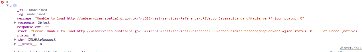
This shows when i expand the red q. I have since taken out the basemap url from exclude identify layor wihtin widget and still does not work
Is the Reference/LPSVectorBasemapStandard/MapServer one of the layers you have setup in the identify widgets json? Can you share your config_Identify.json
Hi Robert,
I don't know what I did but I have seem to have got it working. I think the widget may have been trying to identify all layers within the map rather than just the selected layer.
Cheers anyway,
Finbar
Robert:
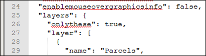
I don't want the identify from "All Layers" to be an option for my users, so I've checked the "Only These" box in the configuration. My config_Identify.json reflects the setting that I want, but "All Layers" continues to be an option in the dropdown list on my application.
Has anybody else reported the same thing? Could I have accidentally changed other settings in this process that would override "Only These"? It doesn't appear to cause any problems, meaning I don't get any results when using identifying "All Layers", but I'd like to get rid of that item from the dropdown.
Below are images of my config_Identify.json, WAB configuration window and widget in my application.


Adam,
Scroll down in the widget configuration UI and you will find an option for "Disable all layers choice"
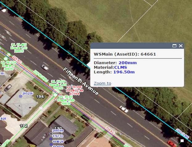
This identify widget is great. Almost exactly what I am looking for. The only thing I need is to be able to move the popup out of the way. Currently it is anchored to the center of the polygon, and it covers half of the selected feature. Is there a way to anchor to the edge of the polygon, or the ability to move the pop up window as desired?
Thank you,
Kevin Milton
Thank you. I wish I would have paid better attention to that.
Kevin,
Currently No. but it is something I will consider for a future release.
hm I've always wanted that, too: the ability to move the Identify popup. As I understood it, the identify popup was part of the API and unfortunately not moveable. I always wondered why ESRI didn't allow for that. I'm sure Dojo can do something easy like that, kind of like jquery ui dialogues. That's usually the first thing my users ask. "Hey, can I get this Identify window out of the way" They are frustrated and unimpressed that they can't move it. I hope ESRI prioritizes this for a future API version. Being able to would make lots of people happy.
Kevin,
People have done some work to make the popup movable for the JS API and it would just be a matter of adding this to the WAB environment.
Having an issue with the popup only setting. It doesn't seem to limit the results after upgrading to 1.2.0.2. Anyone else having this issue?
Leo,
I am not able to reproduce this. Can you start a brand new app and see if it has the same issue?
Thanks Robert for the great widget, very useful and handy.
A question about the results display window though.
Is it possible to format the attributes displayed in the result window (main as well as in pop-up) same as configure pop-up allows in web-map?
A custom attributes display option in configure pop-ups (web map) tool allow users to customise the resultant pop-up attributes (font, colour, text etc.) (Figure 1).
While Identify result window displays the configured attributes in a standard uniform style (figure 2)
Is it possible to customise / format the attribute style in result window of identify widget.
Thanks
Amit
Amit,
No currently there is no support for formatting the results. I will consider this for a future release.
Thanks Robert,
meanwhile I'll try to look for a work around.
Amit
Amit,
If you are a programmer then you can look at the List.js for formatting the results list.
Unfortunately no, I am not a programmer.
I am fairly new to the WAB custom widgets and trying to grasp the overall architecture of the WAB.
I do came across the https://developers.arcgis.com/javascript/jsapi/popup-amd.html through an ESRI consultant.
But in my case the water utilities map service I am using contains 100+ layers, hence customisation might be too time consuming.
Another question:
What parameters I should tweak in style.css to change the font style to bold in the pop up result window?
Amit
Amit,
See this thread. It is taking about my eSearch but the same would work for the Identify widget:
Re: Change color of results fields in Enhanced Search Widget
Amit,
Changing the popups would involve changing the code in the Widget.js lines 1828 thru 1832:
if(cArr[1] !== 'NA'){
content = content + '<em><strong>' + cArr[1] + '</strong></em>: ' + value + br;
}else{
content = content + '<em><strong>' + cArr[0] + '</strong></em>: ' + value + br;
}
Hi Robert,
Unless I'm doing something wrong, the "Disable Link if Null" feature in the Update Link dialog isn't working. Links with <Null> in field still show up in ID widget results.
This feature works perfectly in Flex version.
Best regards,
Barnaby
Barnaby,
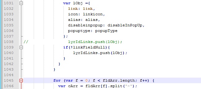
Can you do some testing for me? In the Identify Widget.js file find the showIdentifyResults function and find line 1037 (at least in my code) and replace:
lyrIdLinks.push(lObj);
with
if(!linkFieldNull){
lyrIdLinks.push(lObj);
}
I'm on it. Stay tuned...
I don't think that has any effect:
Robert, note that I have the "Disable Link in PopUp" box also checked, and that is working.
Barnaby,
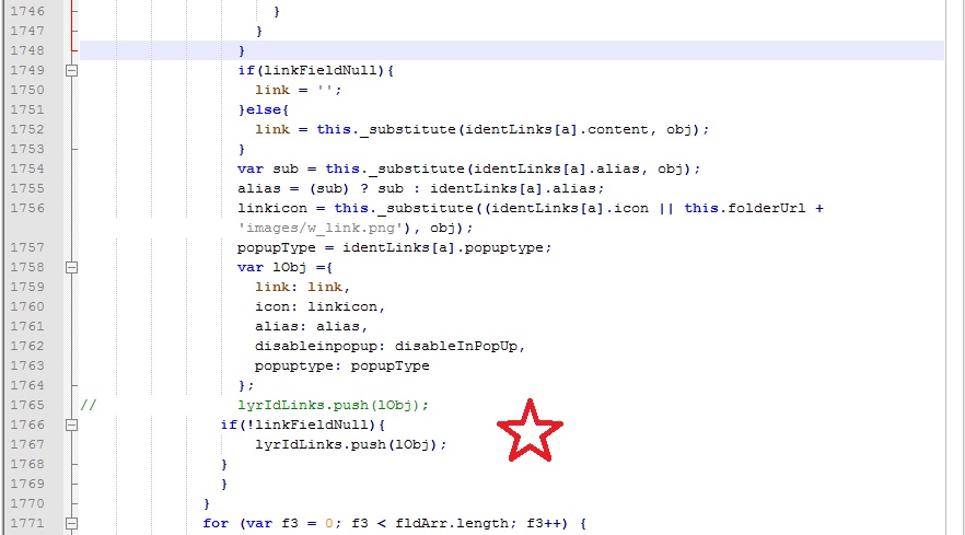
Do the same for line 1779
Robert,
Another question. I have an attribute field which contains a long string, a full reference. Is there a way to turn on word wrap for the ID results so that the whole string doesn't appear on one line?
Having the whole string on one line isn't the end of the world (you can scroll to the right to read the line), but if you have link icons that occur below the long line, the link icons are centered beneath the long string, so you can't see the icons in the ID results until you scroll to right.
Cheers,
Barnaby
Barnaby,
I think I looked into word wrapping before and it was a no go, but I will take a look again.
Still doesn't work, but I changed lines around 1764, not 2044:
Thanks for checking on the word wrap. Another idea would be to have the link icons left-justified instead of centered. Link text already is left-justified.
Barnaby,
I have made the link icons left justified for the next release. I am struggling to figure out why the code I provided is not working for you on the null link matter I have been testing and it works fine for me even when disable in popups is set. Are you putting the changes in the stemApp or the specific app you are testing?
Amit,
I am working on adding some level of control of the results formatting for the next release, at least bold and italics and font color. I will not add the level of customization that AGOL allows (there a big difference between a development team, like AGOL has, and a one man show like me).
Thanks Robert,
Just a basic level of attribute formatting is what I am looking for. This will help in differentiating the attribute label from attribute content, especially on mobile devices.
Amit
Robert,
I made the changes you suggested in the widget.js for that specific app:
\\WABdev_1.2\server\apps\#\widgets\Identify
Is that correct?
When you say the "disable links" works for you, do you mean with or without the changes to widget.js you suggested?
Cheers,
Barnaby
Barnaby,
With the changes
Robert,
Ok, then it appears something is wrong on my end. I'll look into it. Thanks!
Cheers,
Barnaby
Edit: Perhaps the issue has something to do with the fields in the published geodatabase that is being queried by the ID widget. There are 4 fields near the end of the attribute table that contain links. See image below. Often, the first and last fields will have links, whereas the two fields in the middle will have no links, and will be <Null>. I believe, but am not certain, that the first of the 4 fields will always be populated, and sometimes all the fields will be populated.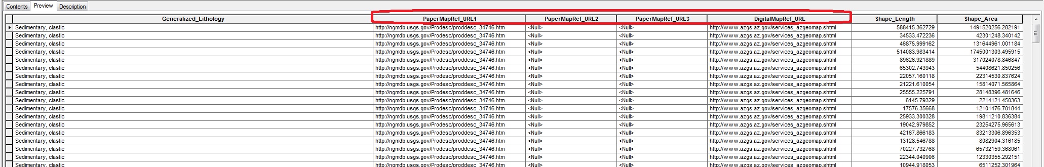
My guess is that your code isn't handling a situation where some of the fields in the middle are Null. I vaguely remember that there was a similar issue for the Flex version of the widget years ago, which I flagged, and you fixed.
Hi Robert,
Great work on Identify Widget. I'm having an issue with identify returning all values from certain attributes. When I use the esearch it returns all values, but for some reason I cannot get identify to return all data from fields I have included. Any thoughts
Ryan,
How is that particular layer added to the map? Is it part of the WebMap and if so was it added as a individual feature layer to the web map (i.e. with the specific layer number at the end of the mapservice url) or was it added as a Dynamic Map Service using just the MapService url with no layer number specified? Or was it added to the map using the Local Layer widget?
The layer is part of the web map. It is a sub-layer to an map service that contains multiple layers. When adding to the identify widget it was added with the specific layer number.