- Home
- :
- All Communities
- :
- User Groups
- :
- Web AppBuilder Custom Widgets
- :
- Documents
- :
- Enhanced Search Widget Version 2.23.1 - 11/22/22
- Subscribe to RSS Feed
- Mark as New
- Mark as Read
- Bookmark
- Subscribe
- Printer Friendly Page
- Report Inappropriate Content
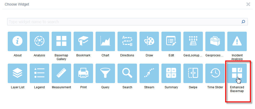
Enhanced Search Widget Version 2.23.1 - 11/22/22
Enhanced Search Widget Version 2.23.1 - 11/22/22
Web AppBuilder for ArcGIS | Help - Enhanced Search widget
List of the latest enhancements and changes:
- Fixed issue with Spatial Relationship settings
Older enhancements or changes
Check the "Older enhancements or changes.txt" in the download for a complete list.
Older Versions
- Mark as Read
- Mark as New
- Bookmark
- Permalink
- Report Inappropriate Content
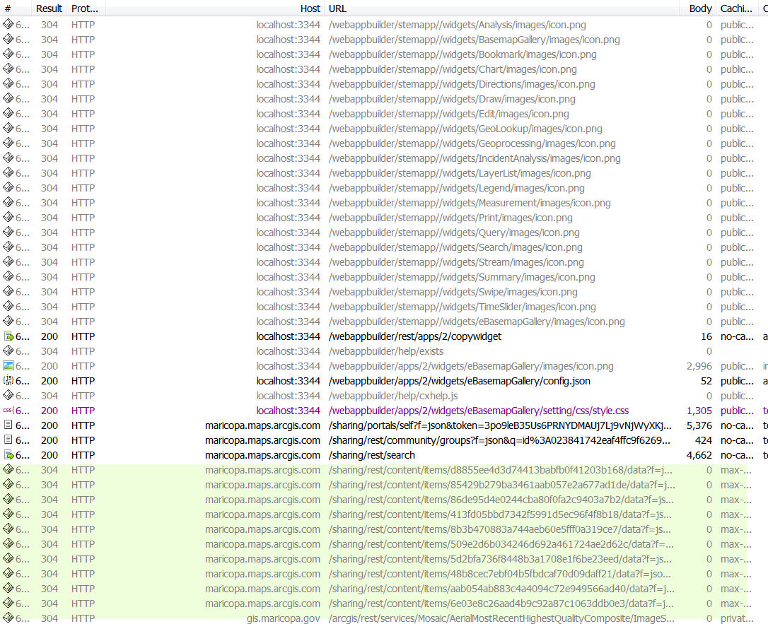
Hi Robert,
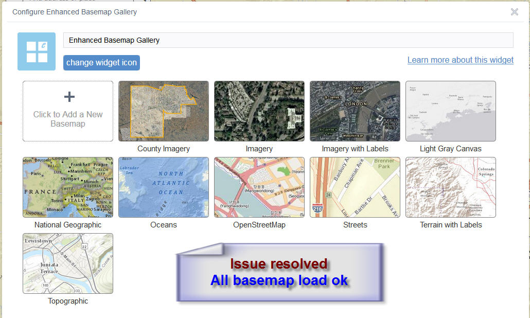
All the basemap thumbnails show up when I add the ESRI Basemap Gallery Widget.
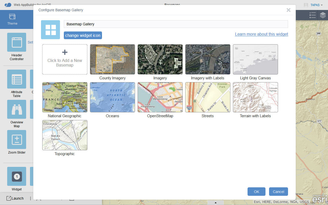
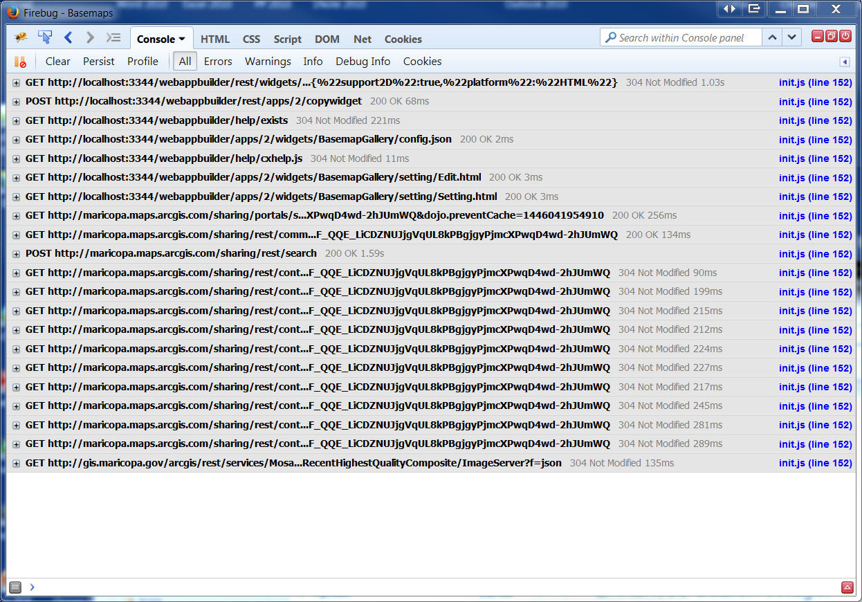
Firebug Console Screenshot.
I can use the ESRI Basemap Gallery Widget.
Now I am adding your Enhanced Basemap Widget.
The Panel is blank.
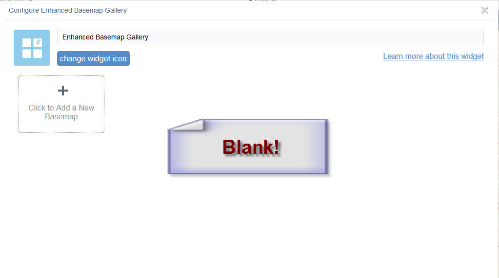
Firebug Console Screenshot.
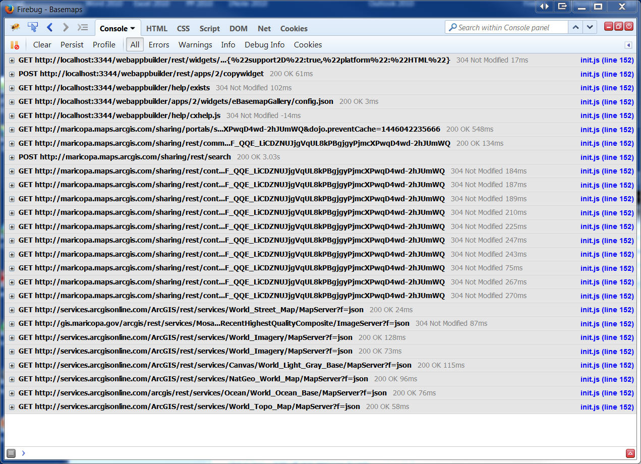
Fiddler Screenshot.
- Mark as Read
- Mark as New
- Bookmark
- Permalink
- Report Inappropriate Content
Tapas,
The new version with the fixes to the issue you outlined is now available.
- Mark as Read
- Mark as New
- Bookmark
- Permalink
- Report Inappropriate Content
Robert...just fyi, this looks like the same issue I was having with the BaseMaps a while back...sorry I never followed up...on to other things again. The one thing that I would mention, in case it helps, is I do not use the standard esri base maps but one with our standard projection (wkid 3338). It appears that Tapas uses custom basemaps also. Maybe that is the common issue? Although Glenn looks to use a esri basemap. just adding my two cents.
- Mark as Read
- Mark as New
- Bookmark
- Permalink
- Report Inappropriate Content
Rebecca,
The proper function of the widget is not suppose to show basemaps whose WKID is not the same as the WebMap that you have selected in WAB. In the last version of this widget I added some code to prevent this widget from adding empty object {},{} to the config (the issue was in my widget and the OTB widget) but I made a mistake in my code and it prevented all basemaps from showing. In the latest version 1.2.0.2 it functions properly. I have tested with custom basemaps using other WKIDs than 102100 and even tested the fact that you can set your Orgs default basemap in AGOL and not show esri basemaps at all. I have defined a custom basemap group in my Org and added my State Plane basemaps to that group and also set my orgs default base map to one of those StatePlane basemaps and my widget works great (the latest version).
- Mark as Read
- Mark as New
- Bookmark
- Permalink
- Report Inappropriate Content
Thanks Robert. I noticed you had put out a new version about a minute after I hit the above "Add comment". I added the update notification to the resource list.....again.  great work as always!
- Mark as Read
- Mark as New
- Bookmark
- Permalink
- Report Inappropriate Content
Hi Robert,
Thanks a million for your lightening fast resolution!
Your fix is working perfectly in version 1.2.0.2 of the Enhanced Basemap Gallery Widget that your released this morning.
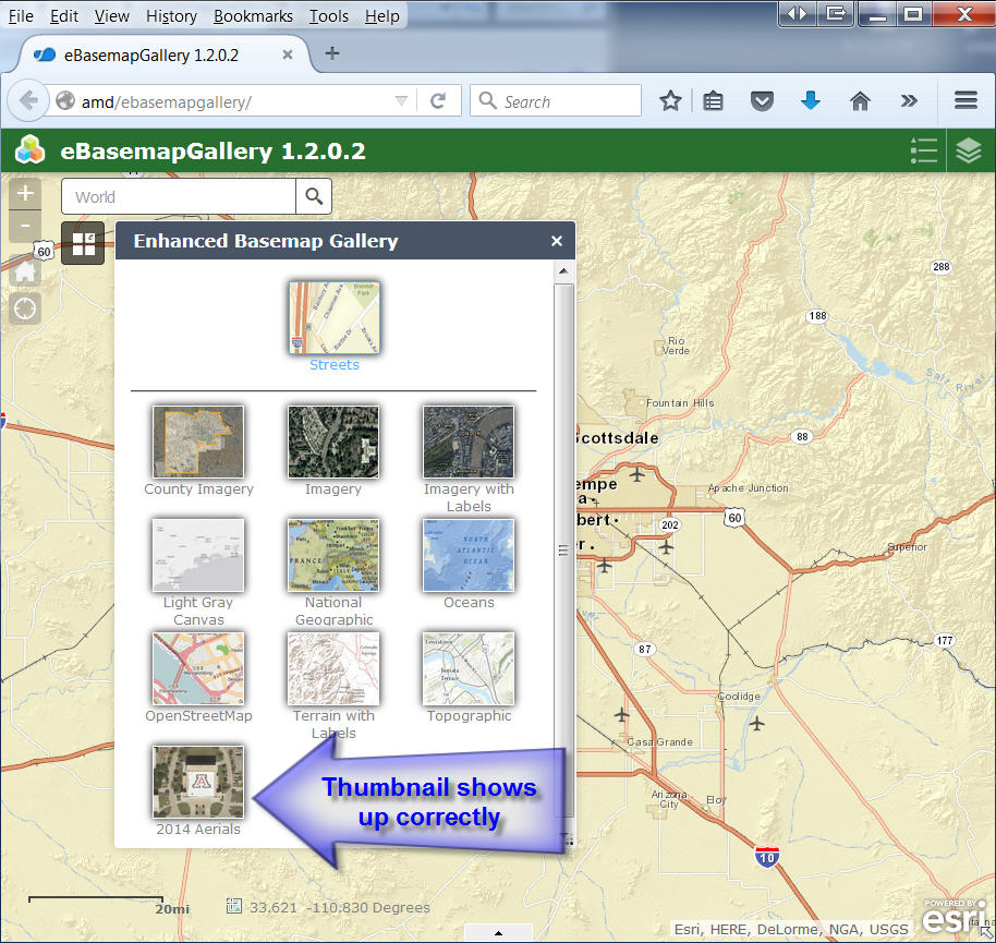
I started with a clean slate by adding your new eBasemapGallery folder to the widgets folder. I am adding an In-Panel widget to placeholder #1.
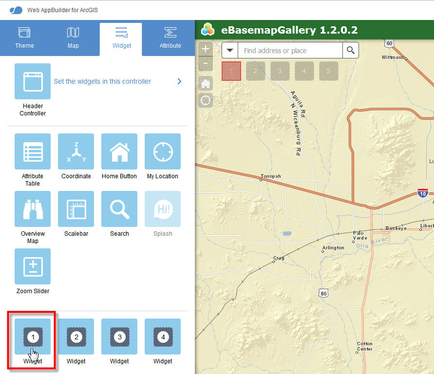
I am selecting the Enhanced Basemap Widget.
All standard ESRI basemaps now load fine!
Next, I am adding my own basemap.
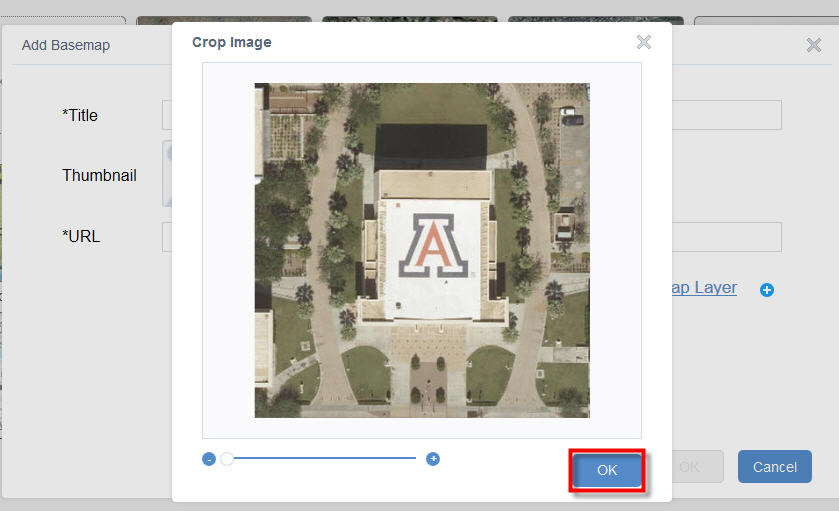
I am clicking on the Thumbnail.
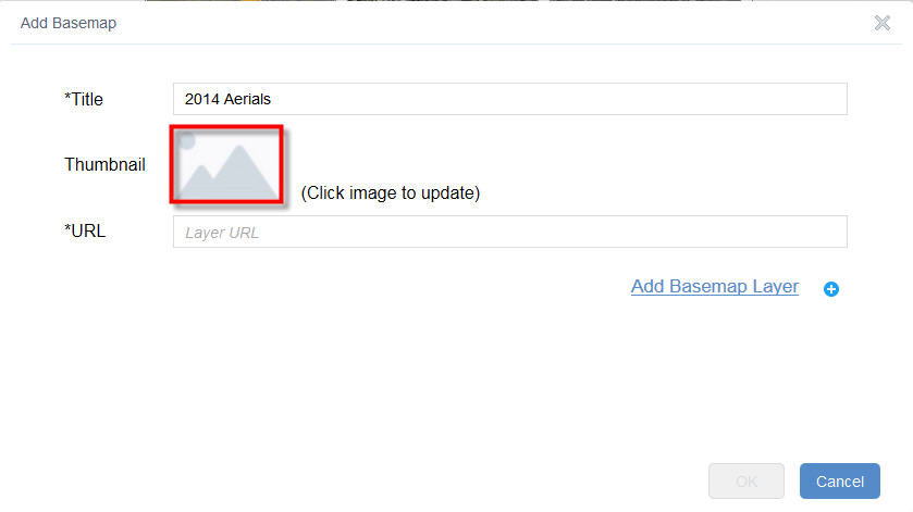
It accepts my image sized at 400 x 400 pixels.
I am entering the URL = http://gis.mcassessor.maricopa.gov/ArcGIS/rest/services/Aerials2014/MapServer
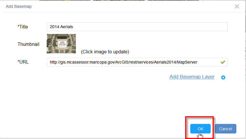
The basemap gets added correctly.
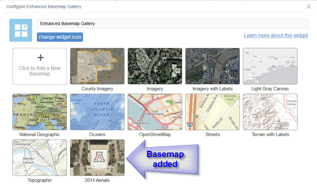
I can select this basemap from the GUI.
Everything works as expected.
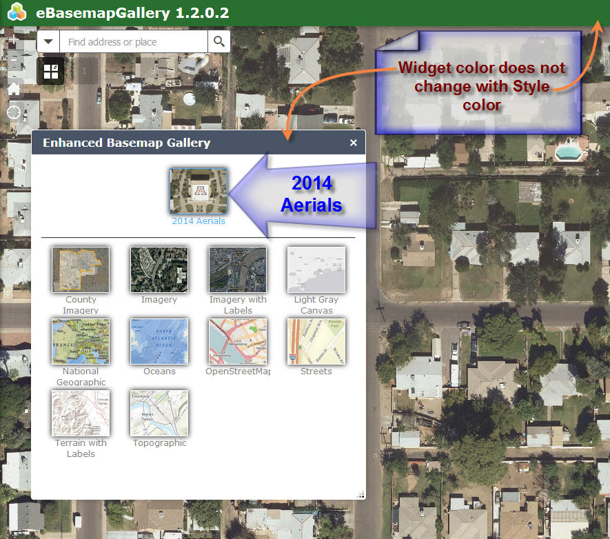
I had just one minor enhancement request.
Could you add the CSS code to make the header color change with the Style color?
I know you had to write about a 1000 lines of CSS code on your eSearch widget to make this happen.
If I open your eSearch Widget, it automatically changes the header color of all widgets to match the Style color.
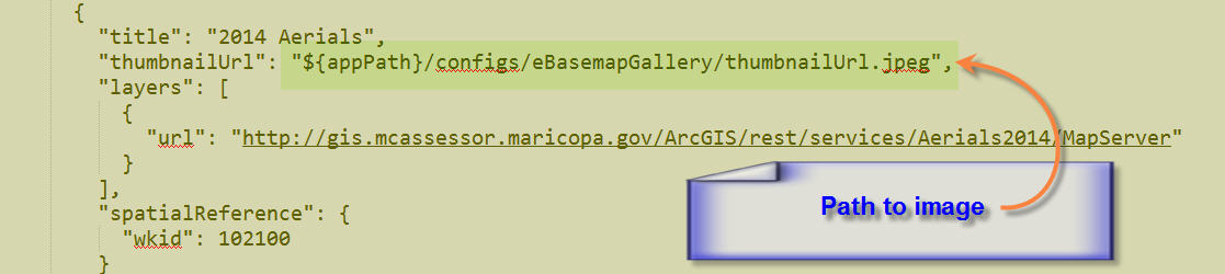
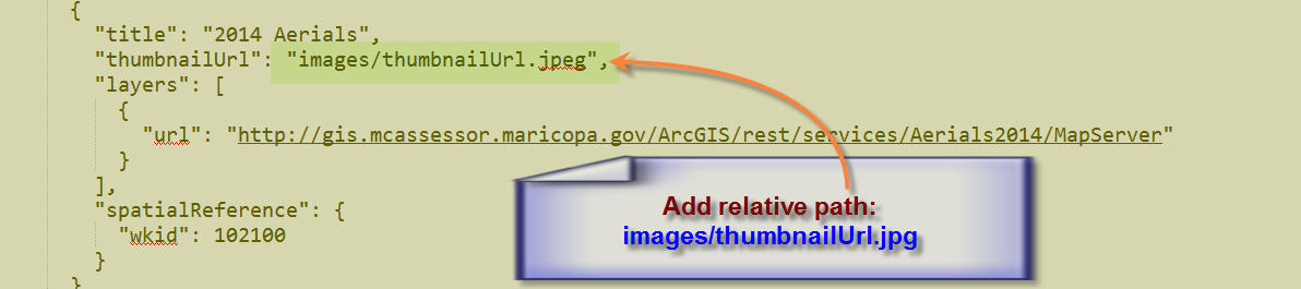
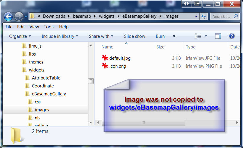
I see that my thumbnail image is being copied to:
server\apps\2\configs\eBasemapGallery
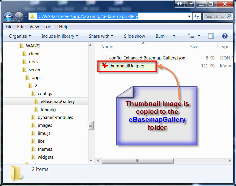
The path to this image is being written to the config_Enhanced Basemap Gallery.json file as:
${appPath}/configs/eBasemapGallery/thumbnailUrl.jpeg
This works perfectly fine within the Web AppBuilder.
However, let's see what happens when I download the ZIP file and deploy the app on my local server.
I have unzipped and copied the contents to:
C:\Inetpub\wwwroot\ebasemapgallery
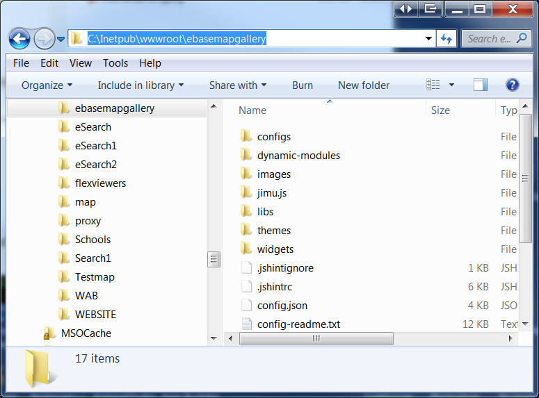
When I launch the app on my local server:
I see that it could not find the thumbnail image.
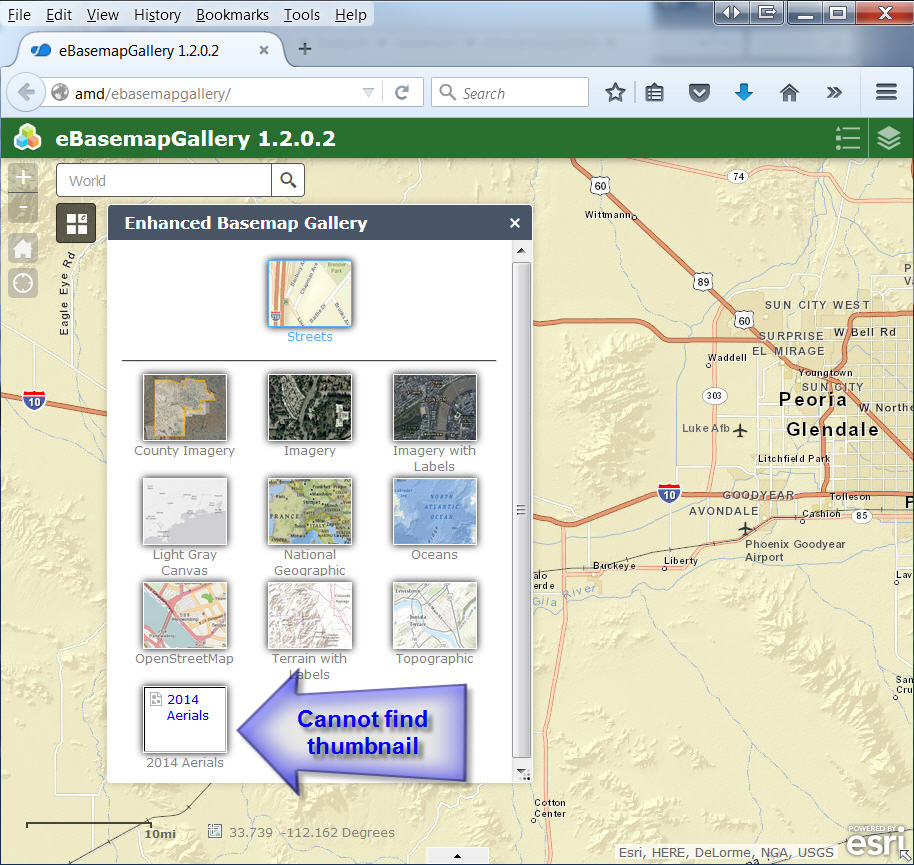
There is a simple fix.
I like to copy the thumbnail images to the images folder:
C:\Inetpub\wwwroot\ebasemapgallery\widgets\eBasemapGallery\images
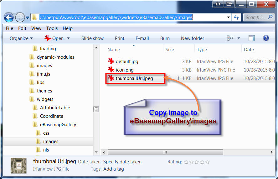
Next, I am adding a relative path to the this image in the config.json file
images/thumbnailUrl.jpg
Now the thumbnail image shows up correctly when I launch the app on my local server:
Robert, I cannot thank you enough for your 24/7 support.
You have set the high benchmark for how a customer driven software development should take place.
Traditional software development environments would never be able to match the fast turnaround times that is possible on the cloud.
You gave us a solution in a matter of minutes!
There were no tech support calls to make, no incident report to fill up, no waiting for 3 months for a patch.
We are thrilled.
- Mark as Read
- Mark as New
- Bookmark
- Permalink
- Report Inappropriate Content
Tapas,
Once you downloaded the app what was the path that was in the json for your thumbnail before you changed it?
- Mark as Read
- Mark as New
- Bookmark
- Permalink
- Report Inappropriate Content
Robert,
Yes absolutely!
I will have it in a few minutes...
- Mark as Read
- Mark as New
- Bookmark
- Permalink
- Report Inappropriate Content
Hi Robert,
After I downloaded the ZIP file, the path to the thumbnailUrl.jpg file in the config_Enhanced Basemap Gallery.json was:
${appPath}/configs/eBasemapGallery/thumbnailUrl.jpeg
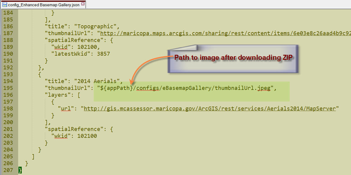
I can see the thumbnailUrl.jpg in the configs\eBasemapGallery folder.
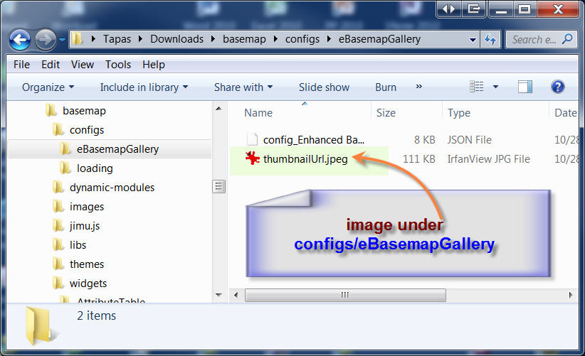
The image was not copied to widgets\eBasemapGallery\images
- Mark as Read
- Mark as New
- Bookmark
- Permalink
- Report Inappropriate Content
- Mark as Read
- Mark as New
- Bookmark
- Permalink
- Report Inappropriate Content
This tool is great, and I appreciate the hours and skill put into it.
I might have missed something, but how do you get the selection to show up as a different color or fill? All mine does is seem to thicken just a bit compared to the other features.
- Mark as Read
- Mark as New
- Bookmark
- Permalink
- Report Inappropriate Content
David,
Are you using symbology from the config or the server? If you choose from the config then you have control of the result symbology if you choose server than the results will be drawn using the symbology specified by the server and if the layer already exists in the map distinguishing between the two will be difficult.
- Mark as Read
- Mark as New
- Bookmark
- Permalink
- Report Inappropriate Content
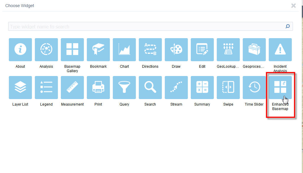
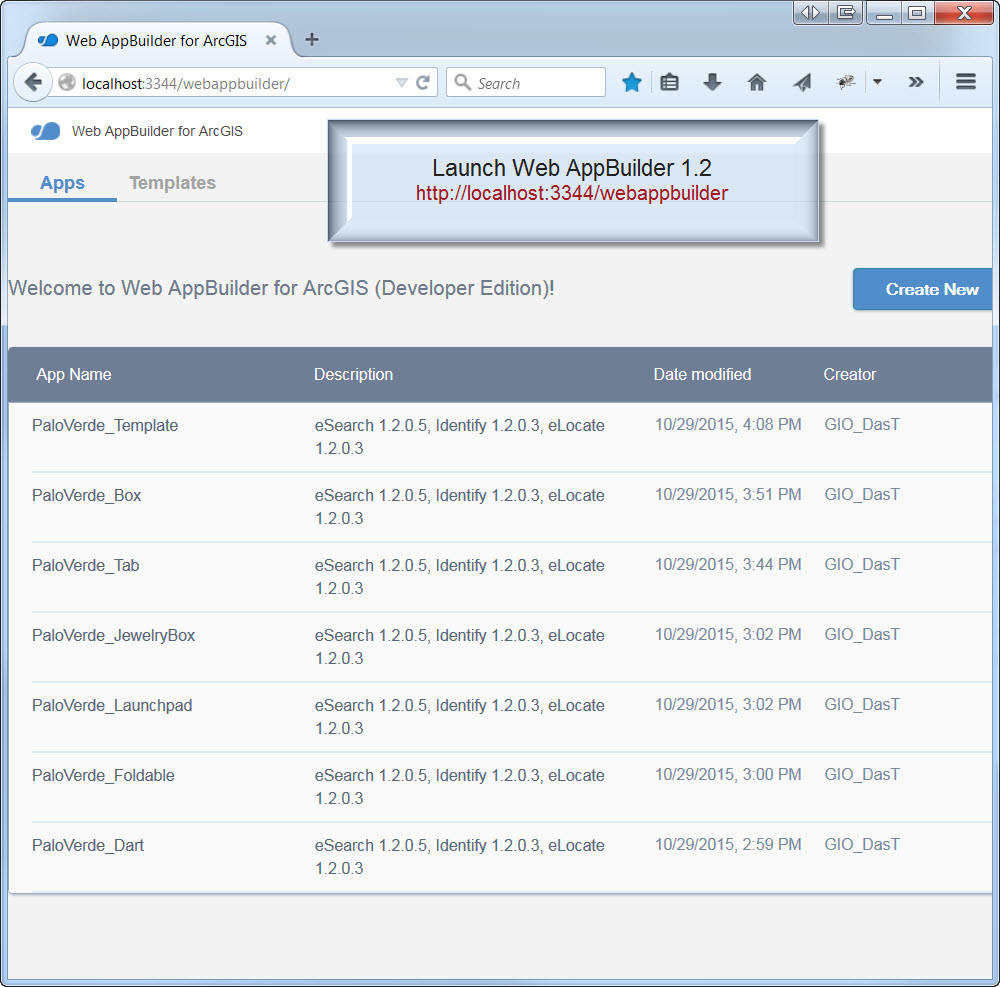
Hi Robert,
I tested out your Enhanced Basemap Gallery Widget 1.2.0.2 with 6 new apps.
I also included the most current versions of all your custom widgets as of 10/29/2015.
Enhanced Search Widget version 1.2.0.5 10/15/2015
Google Street View Widget 1.2 08/25/2015
Share Widget 1.2.0.1 09/04/2015
Identify Widget 1.2.0.3 10/23/2015
Elevation Profile Widget 1.2 08/25/2015
Map Progress Indicator Widget 1.2.0.1 10/23/2015
Enhanced Bookmark Widget 1.2.0.1 10/23/2015
Enhanced Locate Widget 1.2.0.3 10/23/2015
I also threw in these 3:
Add Service Widget 1.1.3 06/19/2015
Add Shapefile Widget 09/18/2015
Zoom Previous Next Widget 1.1.1 05/13/2015
They are all working well together.
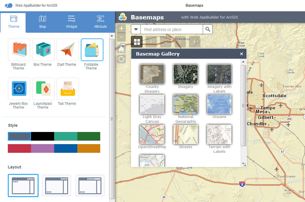
Palo Verde – Foldable Theme
http://www.tapasdas.com/Maps/Phones/app96
Palo Verde – Launchpad Theme
http://www.tapasdas.com/Maps/Phones/app97
Palo Verde – Dart Theme
http://www.tapasdas.com/Maps/Phones/app98
Palo Verde – Tab Theme
http://www.tapasdas.com/Maps/Phones/app99
Palo Verde – Box Theme
http://www.tapasdas.com/Maps/Phones/app100
Palo Verde – Jewelry Box Theme
http://www.tapasdas.com/Maps/Phones/app101
There were just a few minor issues:
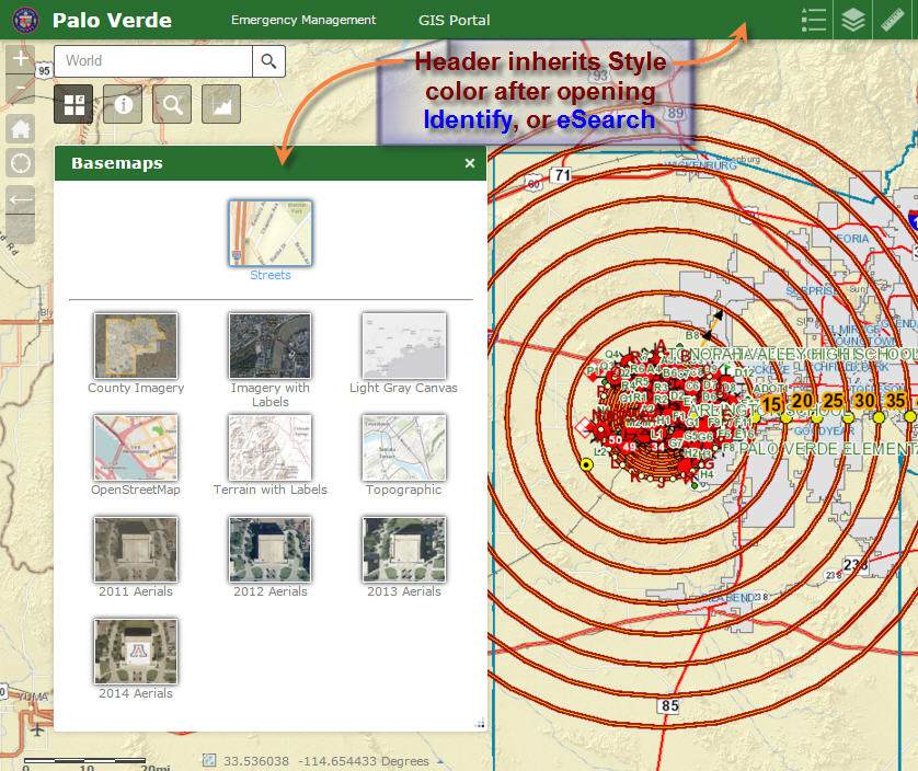
The Basemap Widget header inherits the Style Color only after I open your Identify or Enhanced Search Widget.
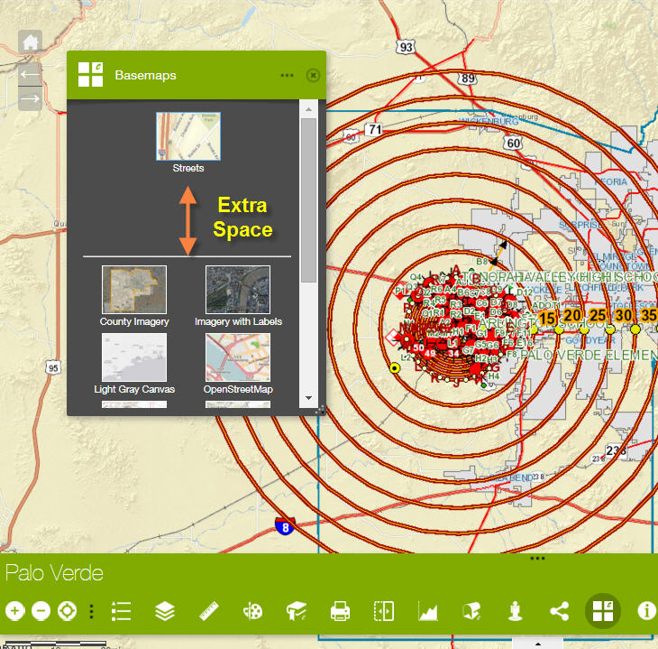
On the Dart Theme, when you open the Basemap Widget initially, there is some extra space on the top section.
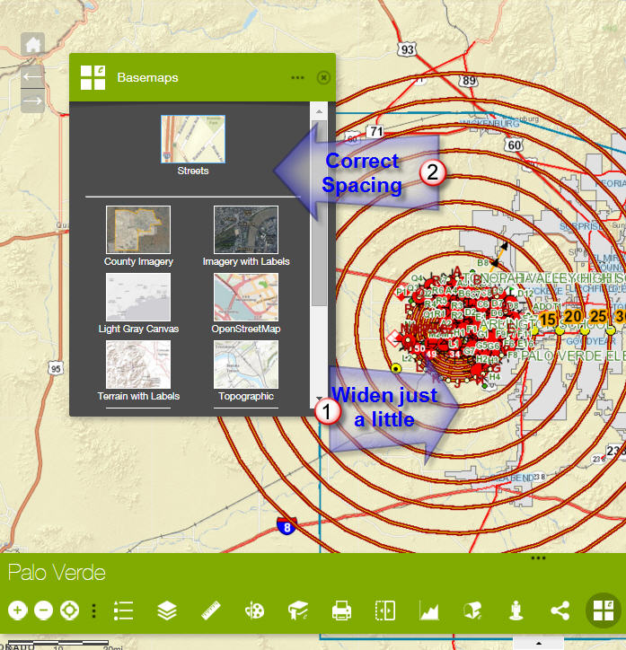
When I drag the lower right corner to widen the widget just a little, the spacing becomes perfect.
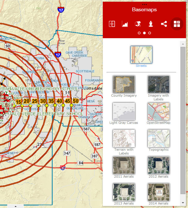
I like how the 2 columns of thumbnails fit the narrower width of the Box Theme.
It is a little tricky to use your Enhanced Basemap Gallery on a Smartphone.
Here I am testing the Jewelry Box Theme on an iPhone 6.
I can easily switch basemaps in Portrait mode.
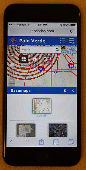
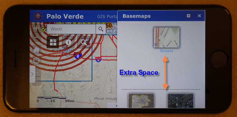
However, in the Landscape mode I see some extra space in the top section.
Here I am using the Foldable Theme.
It works perfectly fine in Portrait mode.
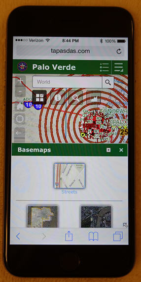
I see the same issue with extra space when rotated to Landscape mode.
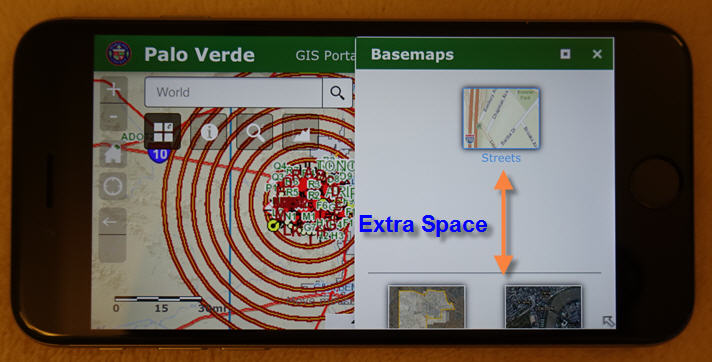
After a lot of tries, I did manage to get a mashup in Portrait mode.
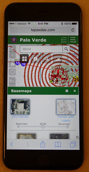
However, no matter how much I tried, I could never get a mashup in Landscape mode.
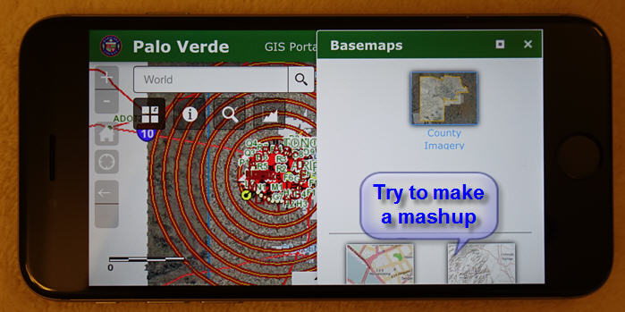
I am trying to hit that tiny green plus symbol.
It always switches my basemap.
I guess if the area was larger, it would be easier to differentiate between a tap on the middle to switch basemaps, and a tap on the upper left corner to make a mashup.
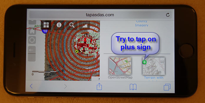
But don't worry about this. I doubt anyone would be using a Smarthphone to use such an application. A web app of this much complexity is meant to be used on a Desktop or Tablet.
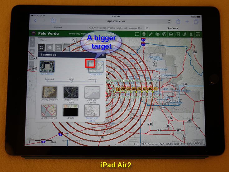
On an iPad, it is much easier to hit that green plus sign to make a mashup, although it would be wonderful if you could make the target area larger.
- Mark as Read
- Mark as New
- Bookmark
- Permalink
- Report Inappropriate Content
I totally missed that step. I did not have it set to "from config". That solved the problem. I appreciate the help. Does this widget work with secured services?
- Mark as Read
- Mark as New
- Bookmark
- Permalink
- Report Inappropriate Content
David,
No one has reported any issue. Are you having issues?
- Mark as Read
- Mark as New
- Bookmark
- Permalink
- Report Inappropriate Content
Robert,
I am about to try some. I just wanted to make sure before I went to far down the rabbit hole. Thanks for clarifying.
- Mark as Read
- Mark as New
- Bookmark
- Permalink
- Report Inappropriate Content
Robert, did you and Tapas ever solve why some of the esri basemaps don't have thumbnails.
this screenshot is just from the standard portal WAB,not the developer version.

- Mark as Read
- Mark as New
- Bookmark
- Permalink
- Report Inappropriate Content
Nope I have only seen this sporadically.
- Mark as Read
- Mark as New
- Bookmark
- Permalink
- Report Inappropriate Content
Hi Glenn,
Yes, I have encountered your problem from time to time. Some of the ESRI basemap thumbnails will show up blank like your screenshot.
I had to do a few things to make it work.
1. Clear the browser cache.
On Chrome, it is <Shift><Control><Delete>
2. Clean up the hard drive deleting all temporary files with the help of CCleaner from Piriform.
https://www.piriform.com/ccleaner/download
3. Start from scratch
Start with a fresh download of Web AppBuilder 1.2
C:\arcgis-web-appbuilder-1.2
Create a New Project
4. Switch to a PC with a faster Internet Connection.
It helps to have a Download Speed above 10Mbps, and an Upload Speed above 1Mbps
- Mark as Read
- Mark as New
- Bookmark
- Permalink
- Report Inappropriate Content
Hi Robert,
I am amazed how fast you have been able to port most of the functionality from your Flex Widgets to the Web AppBuilder.
This is the Web AppBuilder version using your most recent set of 9 Custom Widgets as of 10/31/2015.
Web AppBuilder - Foldable Theme
http://www.tapasdas.com/Maps/Phones/app96/
This is the Flex version of the same application using your Custom Widgets for Flex
Flex Application - Cobalt Blue Theme
http://www.tapasdas.com/Maps/Desktops/web42/
You have made them close enough in functionality to the point where they are interchangeable.
The Web AppBuilder version has the added advantage of running on Tablets and Smartphones that respond to touch sporting a fully responsive design that collapses gracefully to fit the device. It also works on iOS devices where Flash is banned.
We were completely at a loss, when support for the Flex API was dropped.
You came to the rescue!
Nobody else had the knowledge on how to migrate your complex 8000 lines of ActionScript code on your eSearch Widget to make it work within the JavaScript API.
I had one request.
On the Flex version you had a PointBuffer Widget.
It was so easy to drop a few points, enter the buffer distance as a comma separated list, and with one mouse click you got a multi-ring buffer with the option to dissolve them.
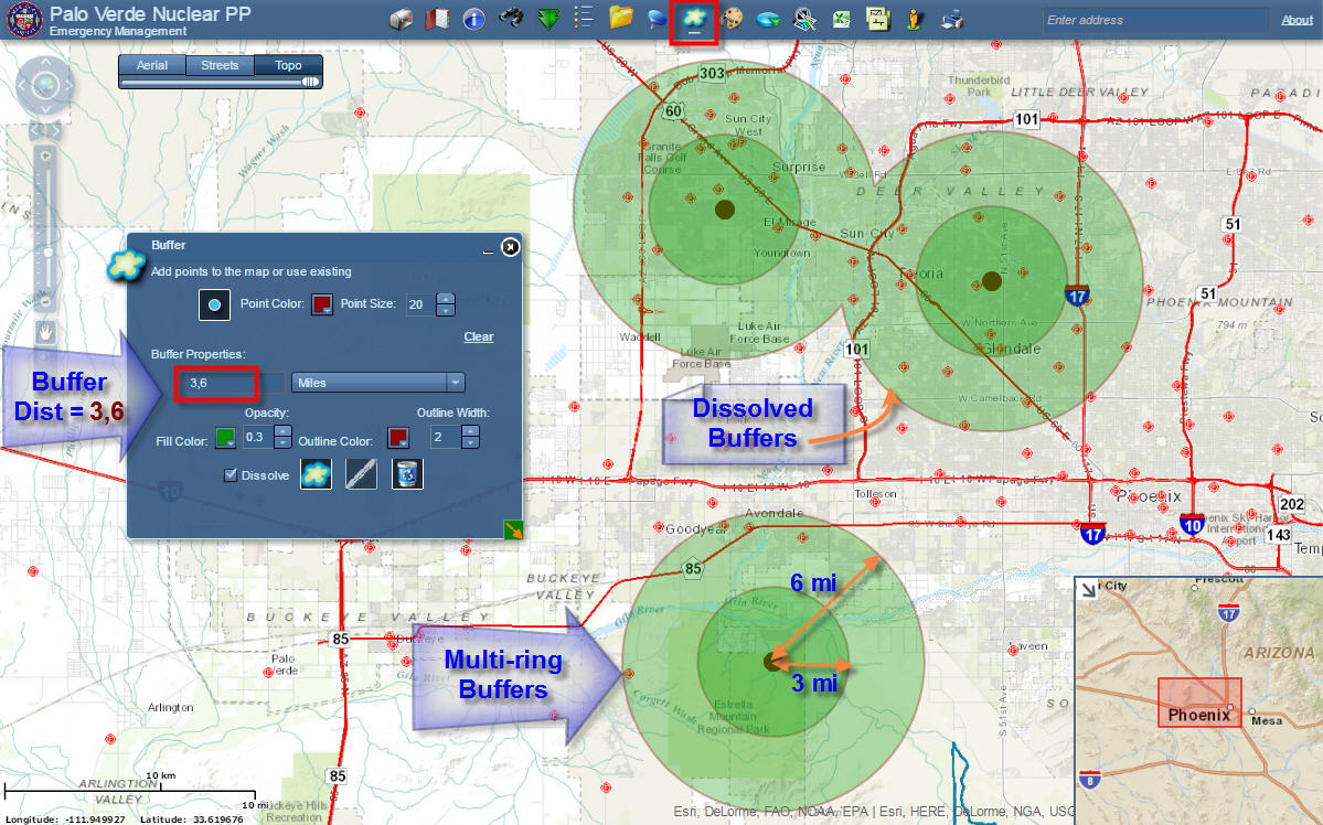
You could immediately get a visual feedback to see what entities were within the buffer zones.
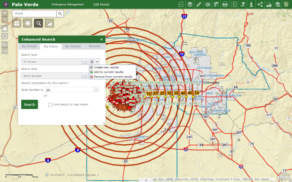
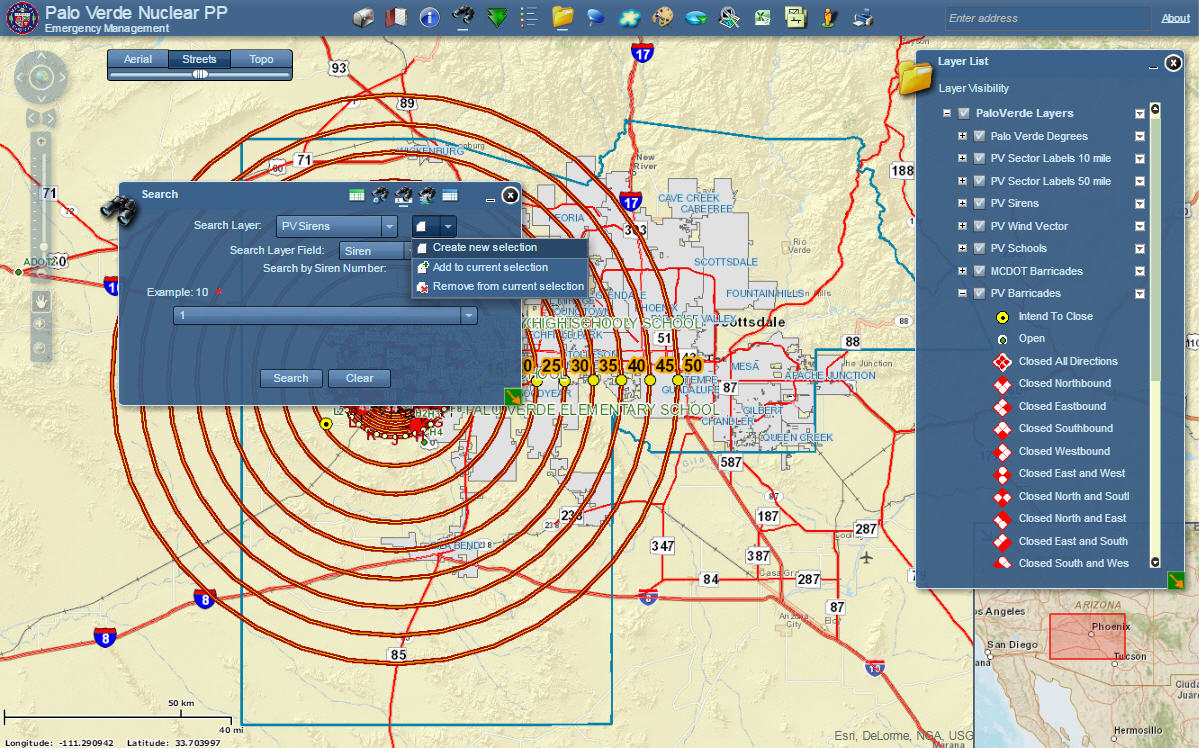
In addition, the output of the PointBuffer Widget could be used as an Input to the Enhanced Search Widget.
You could open the Enhanced Search Widget, and within the Graphical Search Tab, the option to use existing buffer graphics would be activated.
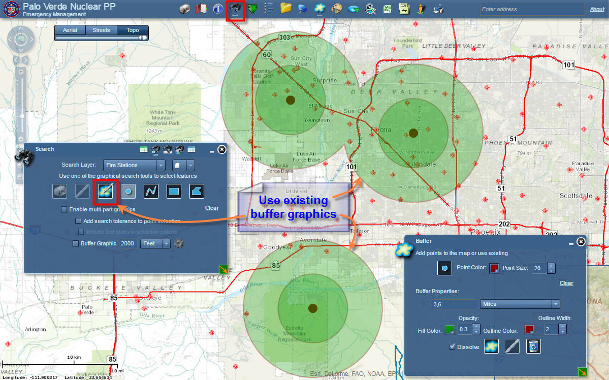
You could then proceed to set your Search Layer and find for example all the Fire Stations within these buffers.
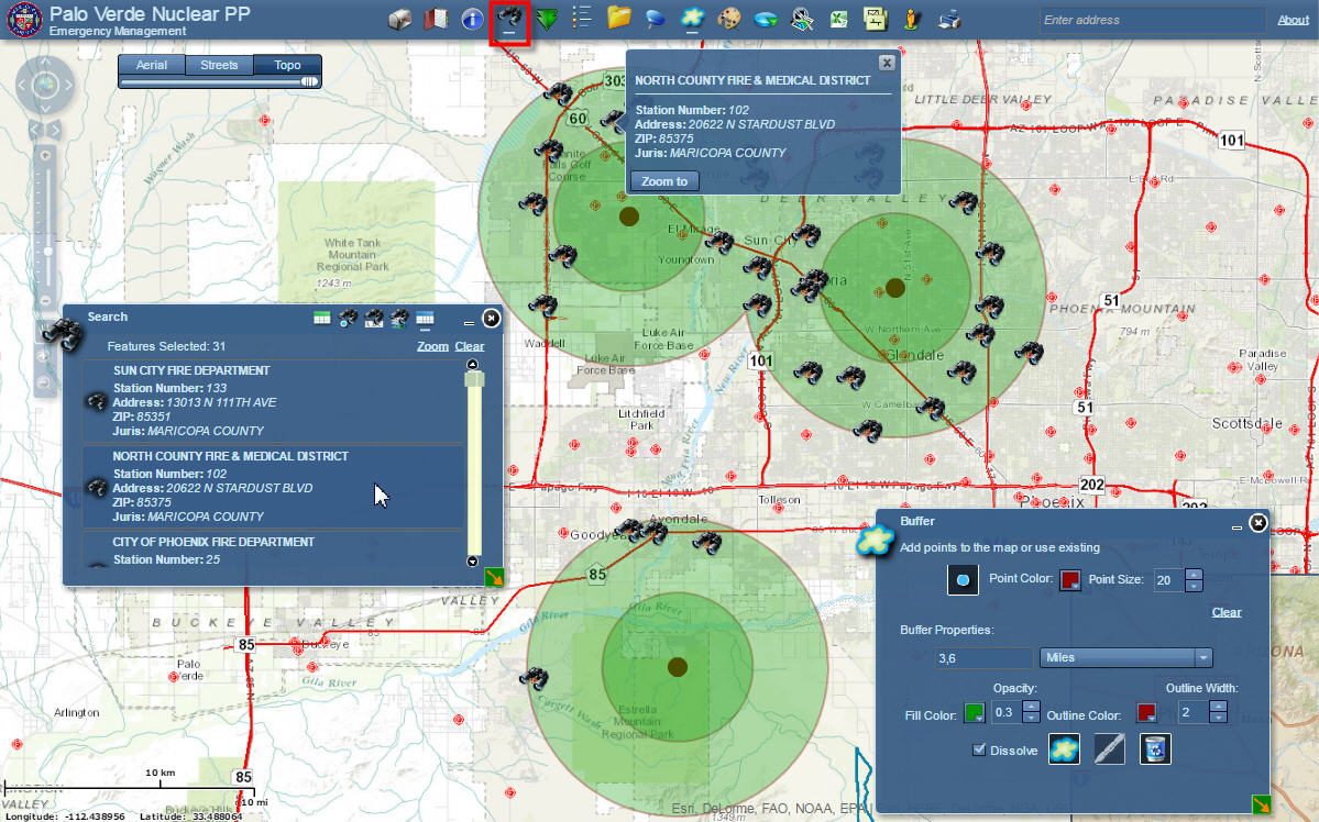
It would be wonderful if you could bring this PointBuffer widget to the Web AppBuilder and tie it to your Enhanced Search Widget.
- Mark as Read
- Mark as New
- Bookmark
- Permalink
- Report Inappropriate Content
Hi Robert,
This has more to do with the default behavior of how Moxie's Team has coded the Attribute Table Widget for the Web AppBuilder.
However, I wanted to run this by you anyway to see if you can give us a solution.
I am adding my own Field Aliases, and I would like them to show up in the Attribute Table.
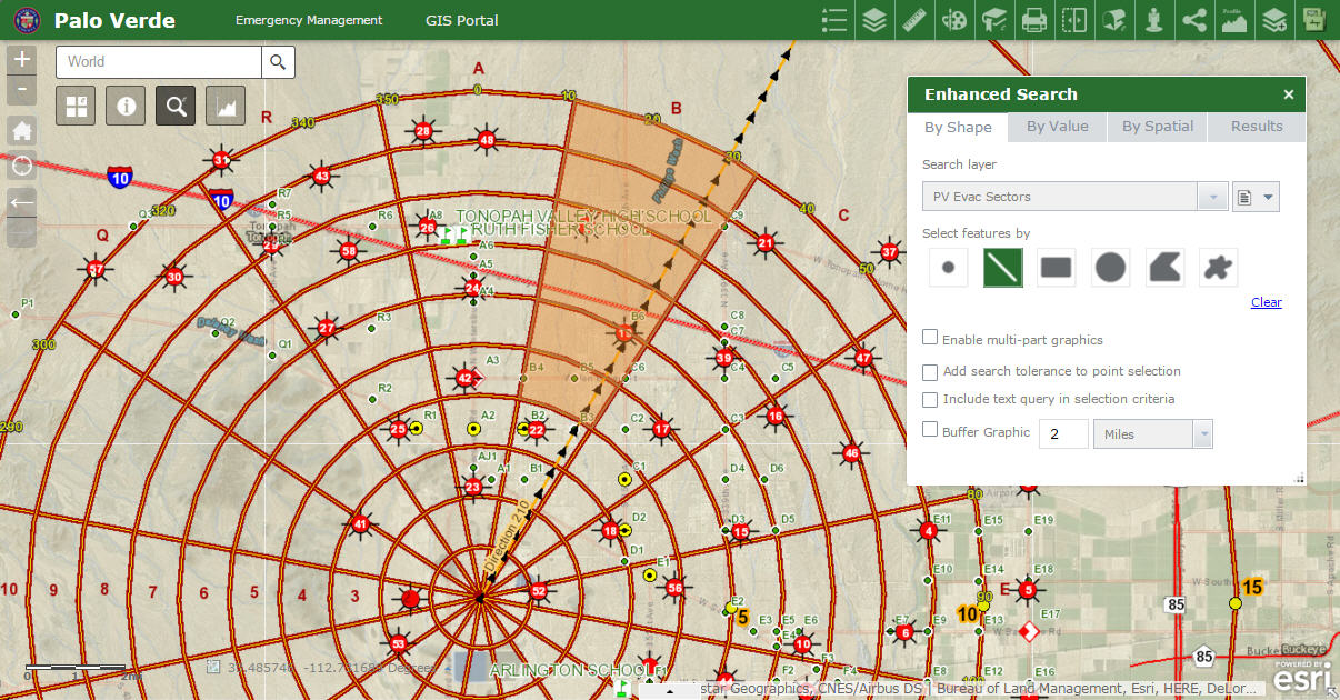
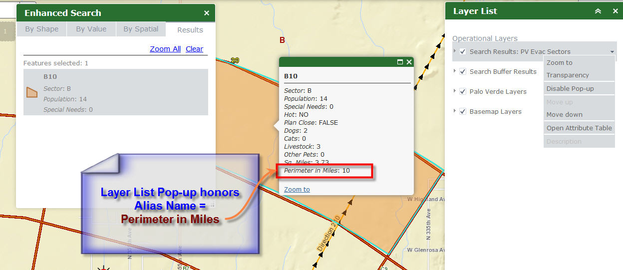
I am editing the Search Layer = PV Evac Sectors
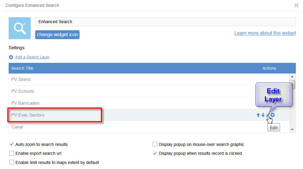
The Name of the field = MILE_
I am entering an Alias Name = Perimeter in Miles
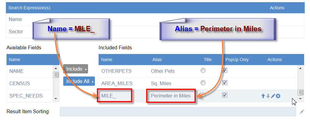
When I use your eSearch Widget to select a feature, the Alias Name is honored in the eSearch Popup. This is good.
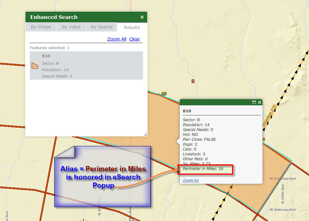
Now I am Enabling the Pop-up option for:
Search Results Layer = PV Evac Sectors
within the Layer List Widget.
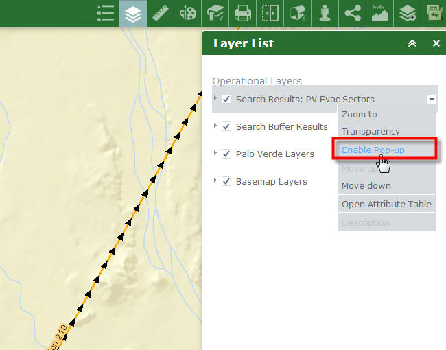
When I click on a selection, the Layer List Pop-up also honors the Alias Name.
This is great!
However, when I Open the Attribute Table from the Layer List choices like so:
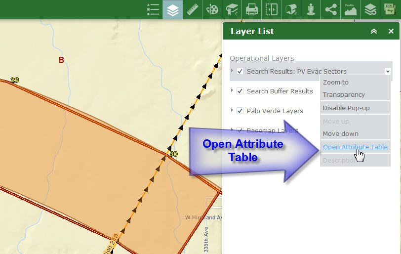
I see that the Attribute Table does not display my Alias Name = Perimeter in Miles.
It shows the Field Name = MILE_
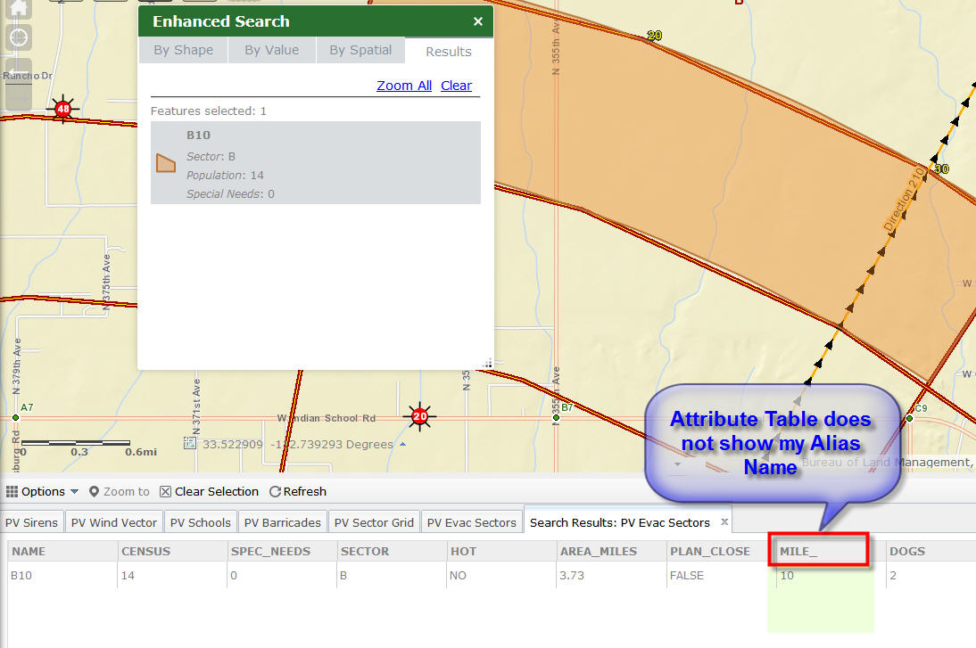
I know that you do not have much control over the ESRI Attribute Table Widget.
But is it possible to write a wrapper code so that the Attribute Table is forced to use the Alias Names, rather than the Field Names it is reading from the map service?
It would be even better if Moxie's Team changes the code so that the Attribute Table will always display the Alias Name by default.
Another enhancement for Moxie's Team would be to hide these fields in the Attribute Table by default
OBJECTID
SHAPE
SHAPE_Length
SHAPE_Area
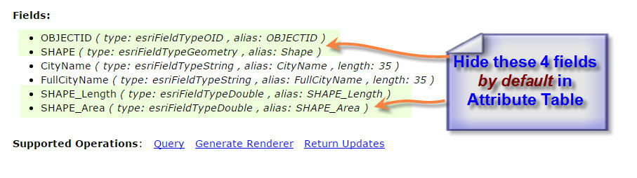
The end user seldom needs to see these, and it clutters up the display.
In the Flex version, this is not an issue as you have complete control over the Data Grid.
The Alias Names are honored in the Data Grid.
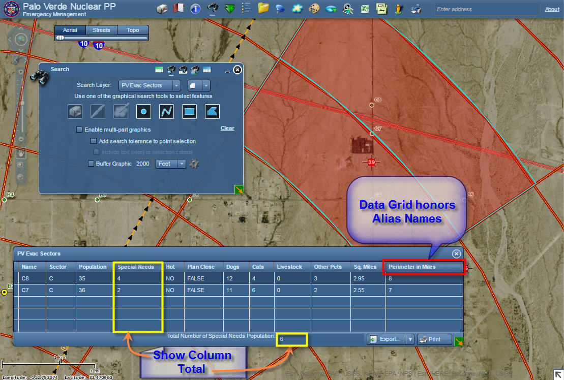
Also, with the Data Grid in Flex, you had a neat option to display the Sum Total of any column.
It is hard to let go of the Flex version. You had tirelessly worked on this platform for more than 6 years and included so many useful enhancements.
The Flex version has a slicker look and feels more robust on the desktop environment.
Maybe it's just my imagination 
- Mark as Read
- Mark as New
- Bookmark
- Permalink
- Report Inappropriate Content
Tapas,
Not sure I have control over field names but I will look into it.
- Mark as Read
- Mark as New
- Bookmark
- Permalink
- Report Inappropriate Content
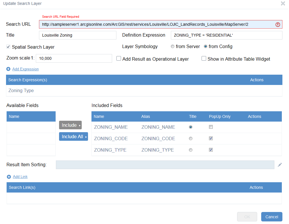
I have downloaded the new version of Web App builder and placed the enhanced search widget 1.2.05 in the \client\stemapp\widgets folder of arcgis-web-appbuilder-1.2. I start a new app and and when i try to configure the enhanced search widget i get errors. when i add my search URL the update search layer prompt looks ok, when i get to to add expression value popup i can't make the expression value it's just blank. I can't click on the box for a drop down.
I am i missing something or doing something wrong?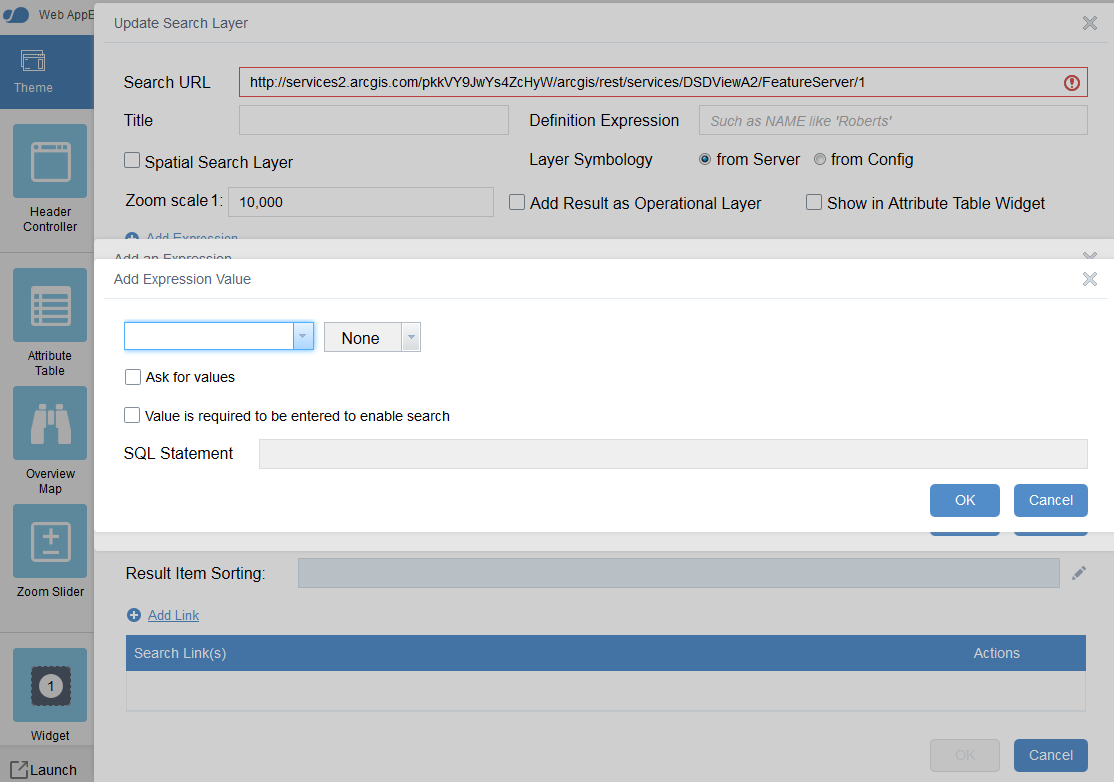
- Mark as Read
- Mark as New
- Bookmark
- Permalink
- Report Inappropriate Content
Hi 2CDSD 2C,
You may want to add a Title.
Your Title field is blank.
See if that makes the Search URL box turn from red to green.
Then you can proceed.
- Mark as Read
- Mark as New
- Bookmark
- Permalink
- Report Inappropriate Content
2CDSD 2C,
I looks like there was a problem with communicating with your service url even before you got to the add expression dialog. Notice the red explanation mark which should be a green check mark.
- Mark as Read
- Mark as New
- Bookmark
- Permalink
- Report Inappropriate Content
I did see that, so after i got the error i closed out of Web builder and restarted it. At first when i input the search url it looks fine but once i click on Add Expression Value and see that i can't create the expression i hit cancel then i get the red explanation. So i again closed out of web appbuilder and restarted the program but this time i click on edit "Louisville Zoning" layer i get the same error...
I have delete the arcgis-web-appbuilder-1.2 folder and re-down loaded arcgis-web-appbuilder-1.2 zip and the and unzip it and placed the enhanced search widget 1.2.05 in the \client\stemapp\widgets folder after all that i still have this issue...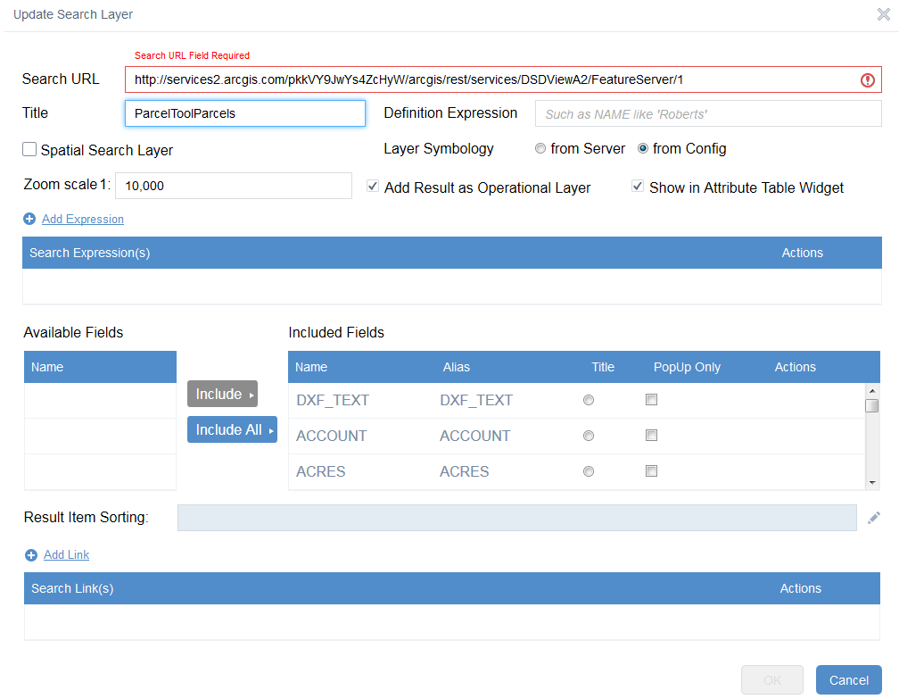
- Mark as Read
- Mark as New
- Bookmark
- Permalink
- Report Inappropriate Content
2CDSD 2C,
I had the same issue. What I did was swop my http services for https secure services and the problem was fixed. I can't explain to you it worked, I just know it did. Why don't you give it a try.
Lara
2CDSD 2C
Sent from Samsung Mobile
- Mark as Read
- Mark as New
- Bookmark
- Permalink
- Report Inappropriate Content
nice to hear some one else is having this issue. Can you give a little more detail on how you swop the http for https? are you referring to the App Registration Application URL: or the Redirect URI:?
- Mark as Read
- Mark as New
- Bookmark
- Permalink
- Report Inappropriate Content
I mean the search url, which is the service you intend to search. As I said, I am not sure why it made a difference in my case. Just change the http in your url to https. Leaving the rest of the url as is. Hope I make sense.
Lara
Sent from Samsung Mobile
- Mark as Read
- Mark as New
- Bookmark
- Permalink
- Report Inappropriate Content
Lara,
That worked! thank you.
Robert, Love the widget!
- Mark as Read
- Mark as New
- Bookmark
- Permalink
- Report Inappropriate Content
Tapas,
Good news is I can change the field aliases for the attribute table widget to match the aliases that are configured in the eSearch config and fields that are not configured are not shown in the AT widget. I am still looking into the Sum field though. Just FYI
- Mark as Read
- Mark as New
- Bookmark
- Permalink
- Report Inappropriate Content
Robert,
Thanks a million!!
You are the Wizard.
If you could force the Field Names in the ESRI Attribute Table to match the Alias Names that I am configuring through your eSearch Config, that would be splendid.
In addition, if the fields that are not configured in the eSearch Config, are not displayed in the ESRI Attribute Table, it would be the icing on the cake.
This is exactly what I was hoping for.
You have came through once again!
Looking forward to testing your new version of eSearch
- Mark as Read
- Mark as New
- Bookmark
- Permalink
- Report Inappropriate Content
Yes that would be very useful. Currently when I set the alias names in the eSearch widget they don't get reflected in the attribute widget. Maybe I'm doing something wrong here......
Also is it possible to give alias names to URL's and send them through to the attribute table as well. Your doing a great job Robert.
cheers
Rod
- Mark as Read
- Mark as New
- Bookmark
- Permalink
- Report Inappropriate Content
Rod,
The alias working in the AT widget is something that will be released for the next version, so no there is nothing you are doing wrong. I have not even tested is url that are sent to the AT widget become hyperlinks. So the likelihood of me having control over assigning an alias is not good.
- Mark as Read
- Mark as New
- Bookmark
- Permalink
- Report Inappropriate Content
Cheers Robert, Yes the URL's do become hyperlinks. Just really need an alias name to tidy them up.
Rod
- Mark as Read
- Mark as New
- Bookmark
- Permalink
- Report Inappropriate Content
Robert,
I noticed a little quirk when clicking on items in the list. If you click on subsequent white (no background) records, then the previously selected item doesn't change it's background back to white. The following 2 changes in the list.js will fix this:
In the add function, Replace
if(item.alt){
domClass.add(div, this._itemCSS);
}else{
domClass.add(div, this._itemAltCSS);
}
with:
if(item.alt){
domClass.add(div, this._itemAltCSS);
}else{
domClass.add(div, this._itemCSS);
}
also in the _onClick function, replace
if (this._selectedNode) {
domClass.replace(this._selectedNode, ((item.alt)? this._itemAltCSS:this._itemCSS), this._itemSelectedCSS);
}
with:
if (this._selectedNode) {
var item_selected = this._getItemById(this._selectedNode);
domClass.replace(this._selectedNode, ((item_selected.alt)? this._itemAltCSS:this._itemCSS), this._itemSelectedCSS);
}
- Mark as Read
- Mark as New
- Bookmark
- Permalink
- Report Inappropriate Content
Hi Robert,
Just a follow-up to the eSearch Widget. Can you address the following?
- Alias names set in eSearch Widget to carry through to Attribute Widget. (You are addressing this one in your next release of eSearch as mentioned above).
- Hide NULL fields in Attribute Widget.
- URL alias naming. See screen shot below re hyperlink of URL coming through to the Attribute Widget.
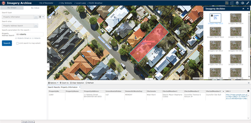
4. Allow for "typeahead" querying when user starts to type into the query displays.
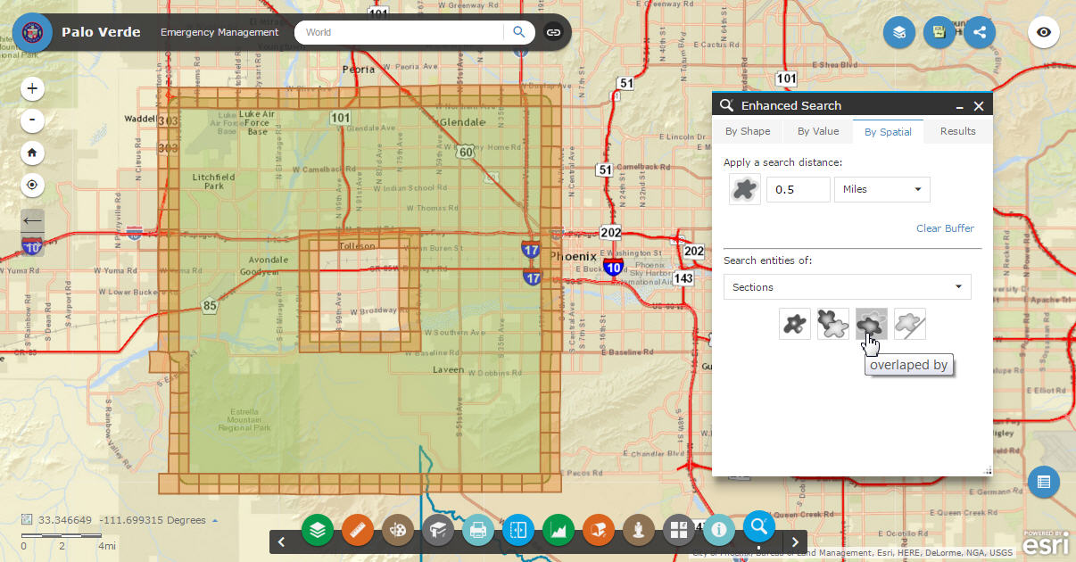
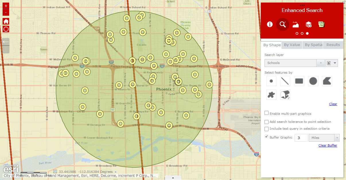
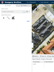
5. Include Clear in "BY VALUE" searching similar to "BY SHAPE" searching see screen shot below.
I have included a link to an "Imagery Archive" App I'm working on that includes your eSearch Widget. This app is designed for the desktop environment. I'm trying to minimise map display interference to enhance
the user's spatial experience. There are other issues in this app, like auto recentre the map which needs
addressing.
Keep up the good work.
Cheers
Rod
- Mark as Read
- Mark as New
- Bookmark
- Permalink
- Report Inappropriate Content
Rod,
2. I do not have that level of control over the AT widget (as it is a OTB esri widget).
3. Like I said I will check but very unlikely.
4. No plans to add this currently.
5. I will consider this for the next release.
- Mark as Read
- Mark as New
- Bookmark
- Permalink
- Report Inappropriate Content
Robert,
I have an odd thing happening
i have a Featureclass that has a definition query set in Arcmap. the query is FEATURECODE = "Transmission Shafts"
some of the field names have alias like FEATUREID set to "Facility Identifier' or FEATURECODE set to "Feature Type".
using either the Esri query tool or your Esearch in the WABdev i am able to load the mapservice layer and populate the field names.
however when i go to build a query using any of the fields and click on the "unique" option none of the records list.
any ideas how to trouble shoot this?
Glenn
- Mark as Read
- Mark as New
- Bookmark
- Permalink
- Report Inappropriate Content
Glenn,
have you looked at the bowsers web console to see if there are errors there that provide a clue to the issue?
- Mark as Read
- Mark as New
- Bookmark
- Permalink
- Report Inappropriate Content
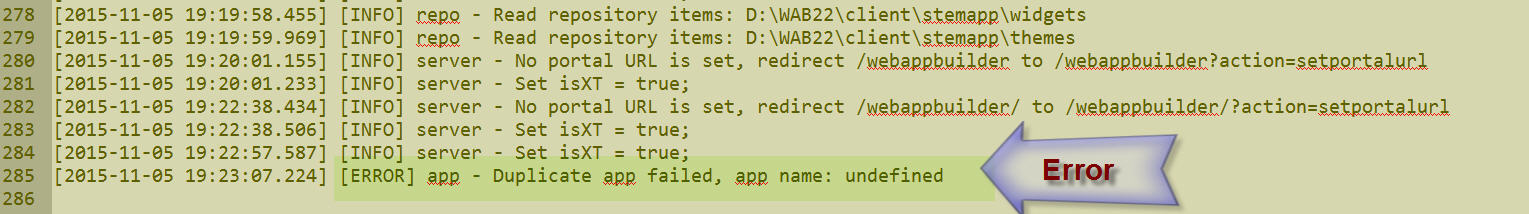
Hi Robert,
I wanted to run this by you.
Do you know what I need to do when I get this error back from Node.js?
Duplicate app failed, app name: undefined
I seem to be getting this frequently using the Web AppBuilder developer edition 1.2
I am starting Node.js by clicking:
C:\Tapas\WAB22\startup.bat
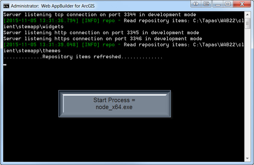
I am opening Firefox and entering:
http://localhost:3344/webappbuilder
This launches the Web AppBuilder developer edition 1.2
There are no errors reported at this stage.
So far, so good.
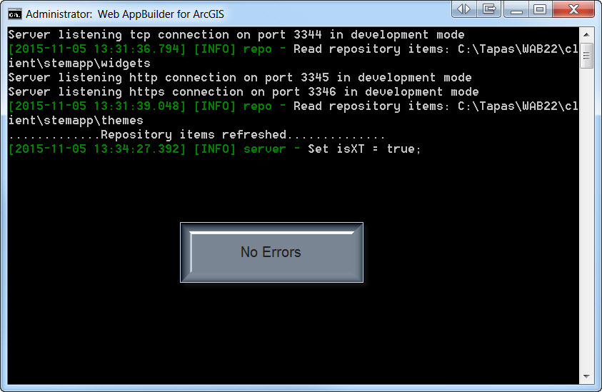
Now, I am trying to Duplicate an existing App.
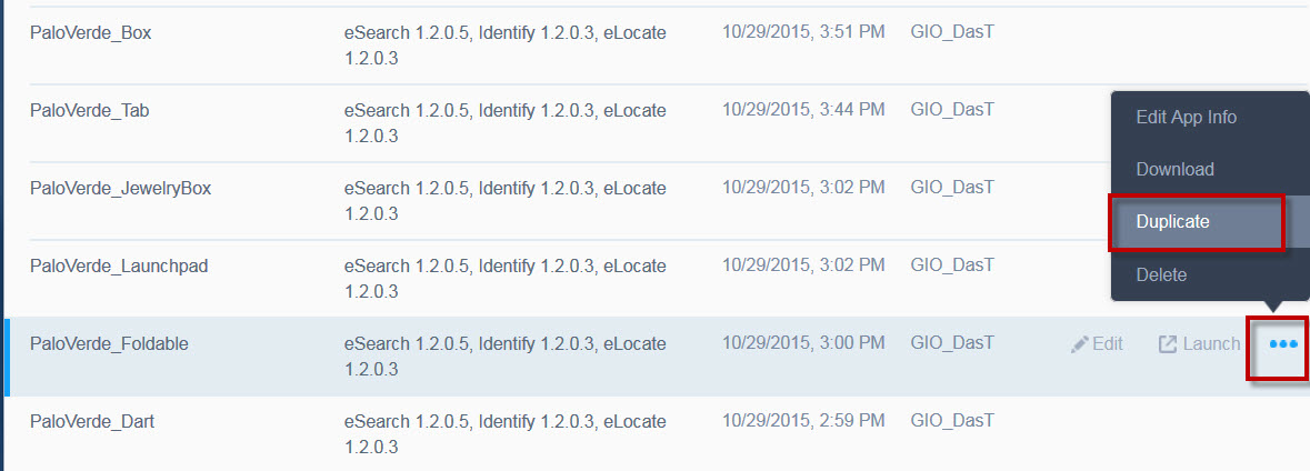
I immediately get this error thrown by Node.js
Duplicate app failed, app name: undefined
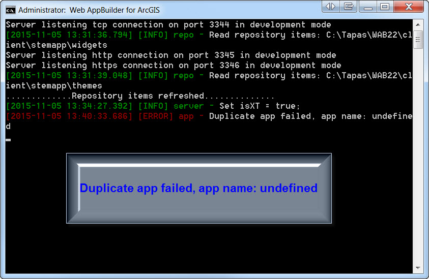
It does not matter which App I select to duplicate.
They all throw the same error.
- Mark as Read
- Mark as New
- Bookmark
- Permalink
- Report Inappropriate Content
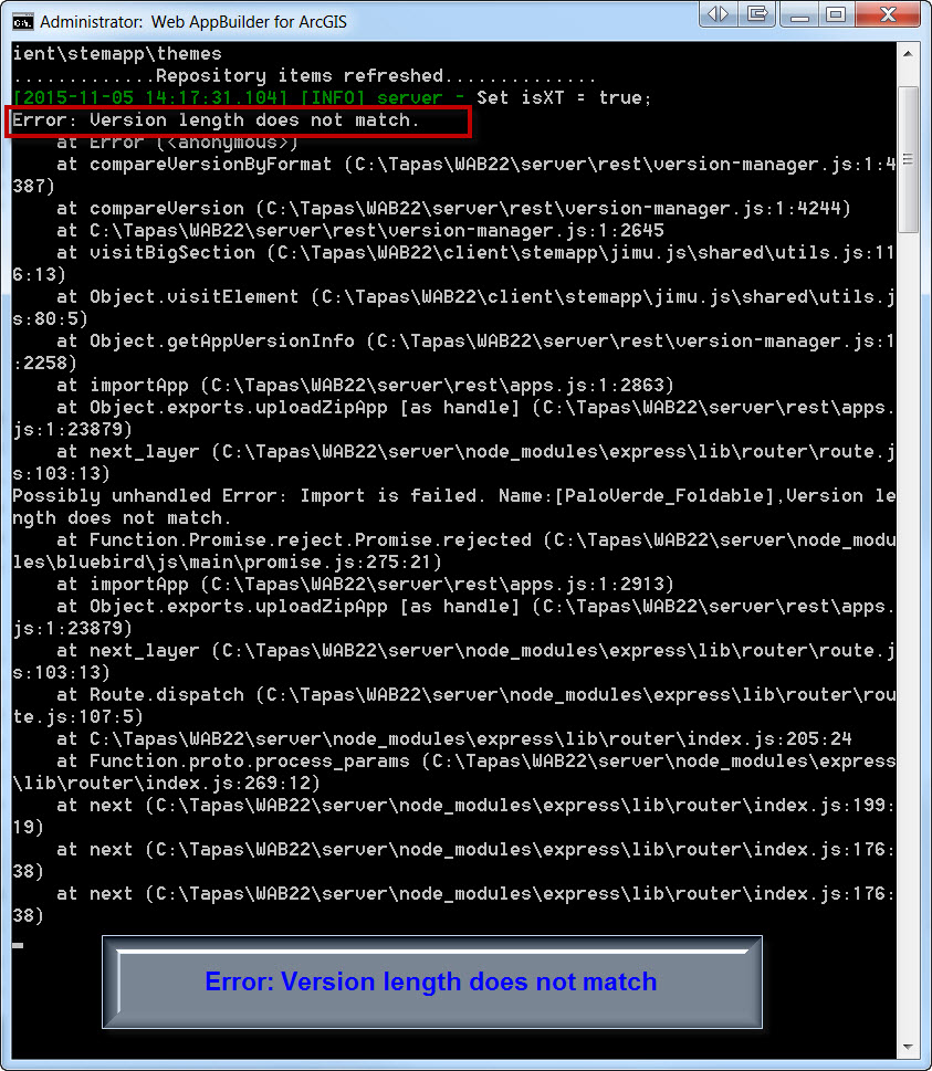
Hi Robert,
Here is some more information.
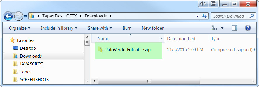
I am downloading one of my apps as a ZIP File.
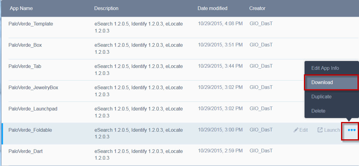
I see the PaloVerde_Foldable.zip file in my Downloads folder.
Now, I am trying to Import this ZIP file.
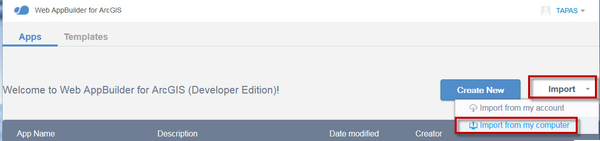
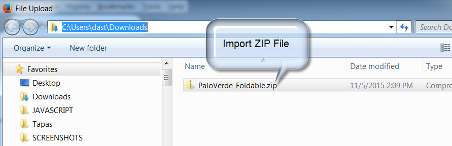
This is where the Import fails.
Here is the error thrown by Node.js
Error: Version length does not match
- Mark as Read
- Mark as New
- Bookmark
- Permalink
- Report Inappropriate Content
Robert,
I will add these requests to the ESRI Ideas site.
cheers
Rod
- Mark as Read
- Mark as New
- Bookmark
- Permalink
- Report Inappropriate Content
Tapas,
Have you looked at the appbuilder.log for details.
- Mark as Read
- Mark as New
- Bookmark
- Permalink
- Report Inappropriate Content
Robert,
No, I have not.
Let me check the server/logs/appbuider.log file
- Mark as Read
- Mark as New
- Bookmark
- Permalink
- Report Inappropriate Content
Robert,
This is the listing of the last few lines of the file:
server/logs/appbuilder.log
It mirrors the same messages that are displayed on the Node.js window
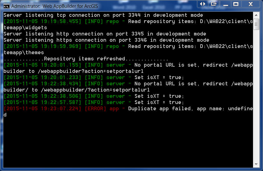
Thanks so much for checking into my problem!
- Mark as Read
- Mark as New
- Bookmark
- Permalink
- Report Inappropriate Content
Robert,
This the ZIP file I get when I download the application:
http://www.tapasdas.com/PaloVerde_Foldable.zip
I cannot import this ZIP file back into the Web AppBuilder.
It throws an error:
Error: Version length does not match
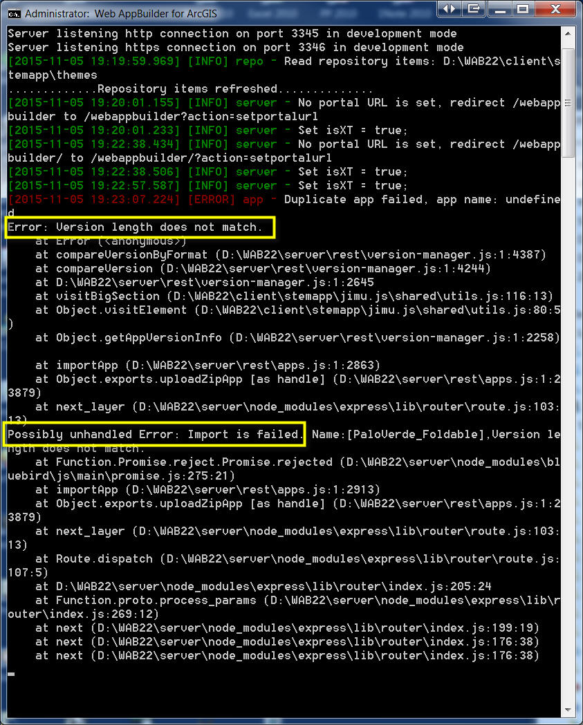
The Web AppBuilder application runs fine.
- Mark as Read
- Mark as New
- Bookmark
- Permalink
- Report Inappropriate Content
Tapas,
After looking as the builders version-manager.js code I would recommend that you manually change the the widgets version numbers to be 1.3 in the main config.json inside the zip and then try to import again.
- Mark as Read
- Mark as New
- Bookmark
- Permalink
- Report Inappropriate Content
yes,
it mentions not being able to find the geometry or the search returns a null value.
i am wondering if the alias is an issue.
when i build the query it is the alias field name that i am picking from the dropdown list.
however when i look at the field names that i can display they are the actual names.
the other odd thing is that the layer is displaying on the map just fine. i can click the mouse and get info on the pts. so it can't be that the geometry is messed up. and i have the shape and objectid fields active in the mapservice.
must be something basic if both the standard and your query tools have the same behavior.
- Mark as Read
- Mark as New
- Bookmark
- Permalink
- Report Inappropriate Content
Glenn,
The actual field names when it come to fields you can display and the alias being used in the expression field chooser is the default behavior, so nothing is wrong there. Is your data joined and if so does the join field name contain any special characters?