- Home
- :
- All Communities
- :
- Industries
- :
- Water Utilities
- :
- Water Utilities Questions
- :
- Water Main Flushing- combining checklists and fiel...
- Subscribe to RSS Feed
- Mark Topic as New
- Mark Topic as Read
- Float this Topic for Current User
- Bookmark
- Subscribe
- Mute
- Printer Friendly Page
Water Main Flushing- combining checklists and field data collection?
- Mark as New
- Bookmark
- Subscribe
- Mute
- Subscribe to RSS Feed
- Permalink
I've been tasked to create a GIS App for our Water Main Flushing Program. I have set up my feature class with the hydrants that need to be flushed as well as the fields for all the data that needs to be collected in the field. It makes sense to use GIS as the platform for this project as this is a location based task. However, within each pressure system, there are certain requirements for pump stations to be turned on or off, tank operating parameters that need to be adjusted and blow-offs that need to be operated. These all have to be done in a certain order either before, during or after the actual flushing occurs (for example: "Step 1:Set Tank XX to short cycle between 8'-9'. Step 2: Set Pump Station YY in "Auto-Mode"). The program runs for a week and there are specific hydrants that are flushed each day. What I would like to do is figure out if there is a way to combine some sort of a checklist with one of the GIS Apps (Collector or Survey 123 or..?) to allow the field user to check off the non-GIS tasks then use Collector to document the actual flushing. Has anybody done this? Is this even possible? I had thought of using Google Sheets to set up a sheet with tabs for each day of the week and set it similar to a "To-do" list where the user would check off each step. The user would have to go back and forth between Google and Collector which is not ideal, but not sure how else to do it.
Any suggestions are greatly appreciated!
Alina
- Mark as New
- Bookmark
- Subscribe
- Mute
- Subscribe to RSS Feed
- Permalink
Just off the cuff... you could display your pressure zone polygons within the collector map (or a separate collector map) and have a table related to each polygon showing the order of activities and have a yes/no or pending/complete column constrained to a domain that the operators could toggle as the complete the specific tasks for each pressure zone?
- Mark as New
- Bookmark
- Subscribe
- Mute
- Subscribe to RSS Feed
- Permalink
That's a good idea, I'll have to think about it. Thank you!
- Mark as New
- Bookmark
- Subscribe
- Mute
- Subscribe to RSS Feed
- Permalink
Have you looked at Workforce for ArcGIS? It creates a task list and can have tasks linked to particular Collector maps, too.
- Mark as New
- Bookmark
- Subscribe
- Mute
- Subscribe to RSS Feed
- Permalink
I just rolled this out a couple of weeks ago.
I used Survey123 for the checklist. I got the idea from this external blog entry. All of the sequenced data is pulled from external csv files. One file for each district. I took advantage of the new grid theme in S123 to get it to fit on one page on an iPad.
There is no map in this form. Mainly because I'm limited to using iPads with no cellular plan. If there was a way for the form to highlight the points on an offline map for each step in the sequence that would be cool. Otherwise, the crews have their paper maps.
Workforce could be used as a checklist but you would still need a different app to record the information for each flushing run. I would probably make a WF project for each district and that would generate a lot of services with layers and tables...it might end up being data management nightmare if you wanted to pull it all together.
Attached is a zip file with the form and a media folder containing 3 files. The district step file and two districts has sample sequencing data so you can see how it works. Just start a new survey based on a file, choose the udf.xlsx file. Once it loads go to the media folder in Windows Explorer and copy the other 3 files into it. Then preview the form in S123 Connect.
- Mike
- Mark as New
- Bookmark
- Subscribe
- Mute
- Subscribe to RSS Feed
- Permalink
Mike,
Thank you for sharing your survey! I had no idea you could pull data from an external source, that is great! I have to play around with the grouping as we have two different crews of two people each day. Within each crew the guys alternate flushing hydrants. So one guy will end up flushing all odd number hydrants while the other one will do the even ones. I thought about splitting the day's work into four csvs instead of two, one for each team member, but that's a lot of files to manage. Do you know if there's a way to automatically skip to every other record in a .csv? It almost feels like I would need another variable besides the counter but I'm not sure how I would set that up in the form.
Another question I had, do you know if you can pull data from other types of files? I would like to include a set of instructions for each day. I've typed all the notes for the day in one Excel cell and it works OK but there isn't much formatting available when you do it this way.
Thanks again, I really appreciate you sharing your survey!
Alina 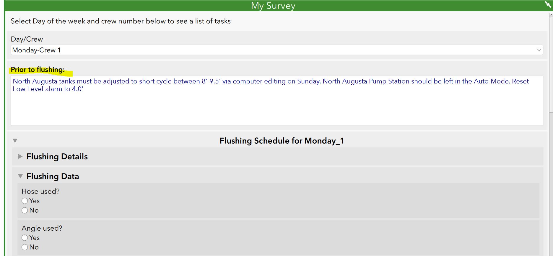
- Mark as New
- Bookmark
- Subscribe
- Mute
- Subscribe to RSS Feed
- Permalink
Hi Alina,
I would use a note question type instead of text. Format your instructions using html syntax.
https://doc.arcgis.com/en/survey123/desktop/create-surveys/xlsformnotes.htm
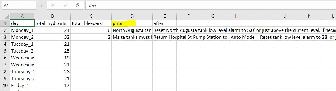
In the csv file, for each row I would include a prior field and an after field. Something like:
day, after, prior
Monday_1, '<b>North Augusta</b> tanks...', '<u>Reset</u> <b>North Augusta</b> tank..'
Use the pull data function to display the appropriate note based on the answer to the day/crew question.
pulldata('csvfile','prior','day', ${day_crew}) - use this for the top of the form to show the Prior note
pulldata('csvfile','after','day', ${day_crew}) - use this for the bottom of the form to show the After note
Mike
- Mark as New
- Bookmark
- Subscribe
- Mute
- Subscribe to RSS Feed
- Permalink
Mike,
I think I'm almost there, I was using the note type. I'm not sure how to get the HTML formatting within the csv file.
If I type <b>Text here </b> the code will show up instead of formatting. I tried quotes and double quotes in front of the <b> but that didn't work. Is there a trick?
Thanks!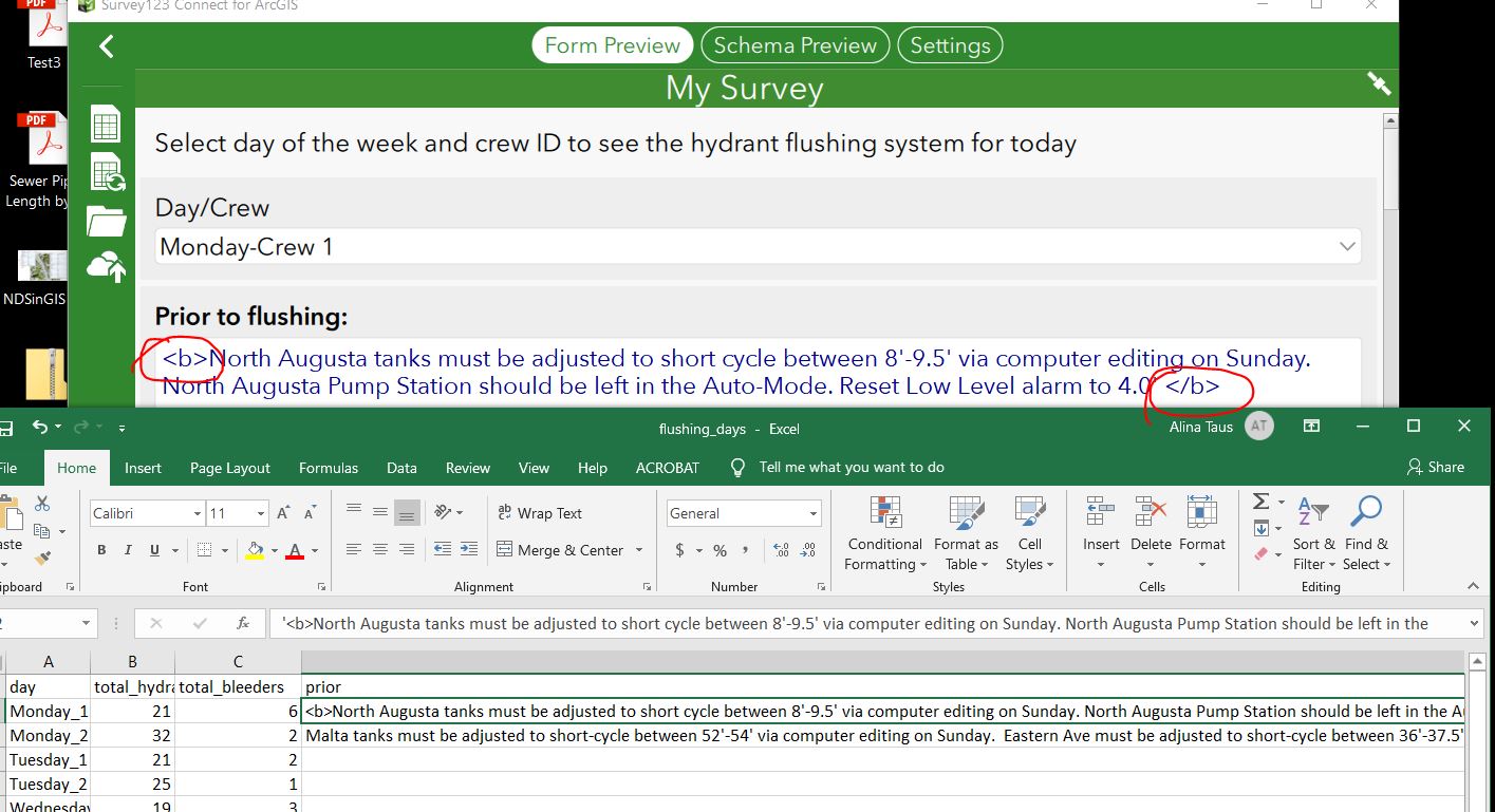
- Mark as New
- Bookmark
- Subscribe
- Mute
- Subscribe to RSS Feed
- Permalink
I figured it out. The appearance for that note was set to "multiline". I got rid of any formatting and now it works!
- Mark as New
- Bookmark
- Subscribe
- Mute
- Subscribe to RSS Feed
- Permalink
I am testing out the survey from my iPad and I am running into a few issues. The first one which I was able to finally figure out had to do with the length of text stored in my .csv. Apparently you need to make sure the text stored in a cell is no longer than 225 characters otherwise you'll get this error message that reads :"String or binary data would be truncated. The statement has been terminated." which will prevent you from submitting a survey from a mobile device. The issue has to do with an ArcGIS Online limitation. More info about this here
The second issue has to do with the actual survey submission. Mike, what is the workflow for your crew? Do they leave the Survey open and only submit after they get through all the hydrants for that specific district? I was testing to see if a survey response can be edited after it is submitted or if I could save a draft and then go back to it and add more flushing data. Since each survey response can have anywhere from 20 to 30 hydrants that need to be flushed, I was hoping I could save the response at various times. I noticed that if I do that, the data that's suppose to be pulled from the .csv with the flushing details will no longer display. So for example, I start a new survey, skip to hydrant #4 out of 21, fill in my data then hit save as draft. When I go back to that draft, I won't be able to see any of the flushing details for hydrant #5 or any others past #4. Is there a way to get around this?
Thanks!