- Home
- :
- All Communities
- :
- Industries
- :
- Water Utilities
- :
- Water Utilities Questions
- :
- Re: Utility Network Services Offering
- Subscribe to RSS Feed
- Mark Topic as New
- Mark Topic as Read
- Float this Topic for Current User
- Bookmark
- Subscribe
- Mute
- Printer Friendly Page
Utility Network Services Offering
- Mark as New
- Bookmark
- Subscribe
- Mute
- Subscribe to RSS Feed
- Permalink
ArcGIS Utility Network Management extension (Utility Network) is designed to provide a foundation for utility GIS solutions for many years to come. Utilities can now support business functions far beyond traditional GIS implementations including:
- The ability to model, edit, and analyze complex networks of facility infrastructure using all Esri platform clients whether in the office or out in the field
- Enabling key modeling concepts to better support a true representation of what is on the ground, while fostering an easy exchange of network information with other mission-critical systems
- Support for highly responsive editing and analysis capabilities and much more
Esri has created four services packages as described below which are intended to help utility customers prepare for and take advantage of the Utility Network new capabilities. The following provides an overview of each services package:
- Implementation Planning Strategy:Conducting a discovery workshop to review key business requirements and processes, system integration requirements, geospatial workflows and data
- Conducting a discovery workshop to review key business requirements and processes, system integration requirements, geospatial workflows and data
- Developing a Utility Network Planning Strategy Document containing recommendations in the follow areas:
- Gap analysis between your data model(s) and the utility network asset package
- Extending the electric, gas, or water asset package
- Extending utility network rules
- System integration
- Data preparation considerations for data migration
- Staff training plan
- Data Health Check
- Your business systems require clean GIS data to operate effectively
- Validate if your existing data is UN ready before embarking on a full-scale data migration project
- ArcGIS Data Reviewer training and implementation
Pilot Project/Proof of Concept:
- Data model / asset package configuration
- Data migration (migrating your data—not an Esri sample dataset)
- ArcGIS Pro project setup and configuration of editing templates
- Services configuration and publishing
- Configuration of branch versioning and network / subnetworks
- Data Migration Training Workshop (using Esri provided sample data)
- Workshop topics include:
- Asset package modeling
- Rule modeling
- Data migration concepts
- Asset package loading into the UN
- Workshop topics include:
Any combination of these packages can be provided based on your needs to receive consulting from Esri as you make the transition to the Utility Network. Please contact your Esri account manager for additional information.
- Mark as New
- Bookmark
- Subscribe
- Mute
- Subscribe to RSS Feed
- Permalink
Hi Don,
I am playing with UN and Water Distribution Utility Network Configuration.
Everything is up and running nicely now and I can edit existing features.
As the next step, I would like to add a few subnetworks in my country(South Korea) and add some test data.
But I am not sure where to begin. Is there any easy-to-follow tutorial in creating a new service territory, tiers, subneworks etc?
I tried to create a service territory with/without network topology enabled. Both of attempts failed to create a new territory.
Any help or pointer would be appreciated.
Thanks.
Regards,
Min
- Mark as New
- Bookmark
- Subscribe
- Mute
- Subscribe to RSS Feed
- Permalink
Hi Min,
There is a walk-through on the ArcGIS Pro site<https://pro.arcgis.com/en/pro-app/help/data/utility-network/configure-a-utility-network.htm#ESRI_SECTION1_7820783BE7FD4E14A4B05A22D70E8764> that addresses most if not all of your questions. Please review and let me know if I can be of further assistance.
Regards,
Don Carson| Esri Professional Services | Manager, Utilities, Telecom, & Pipeline Consulting Practice T: 972-699-0014 ext. 5668 | M: 214-755-8487 | E:[email protected]<mailto:[email protected]> | esri.com/services<www.esri.com/services>
- Mark as New
- Bookmark
- Subscribe
- Mute
- Subscribe to RSS Feed
- Permalink
Hi Don,
Thanks for the pointer. It would be very useful if a video tutorial is available somewhere.
I will follow the Pro documentation for now.
Regards,
Min
- Mark as New
- Bookmark
- Subscribe
- Mute
- Subscribe to RSS Feed
- Permalink
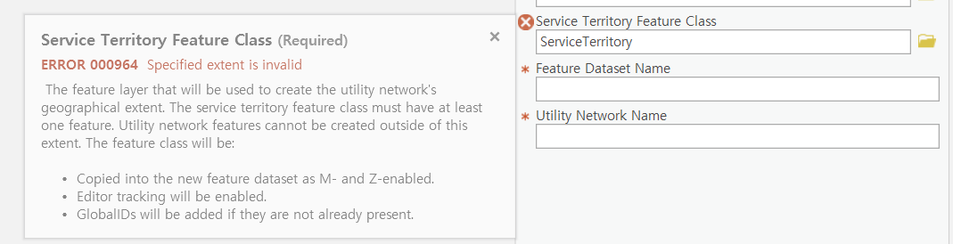
Hi Don,
I am setting up Water Distribution Utility Network Configuration again. This time I changed Asset Package Spatial Reference to "Korea 2000 Central Belt". This tool run with out an error. But when I try to Stage Utility Network, I get this "Spatial Extent is invalid" error.
Is there any way to work around this?
Thanks for your help.
Regards,
Min
- Mark as New
- Bookmark
- Subscribe
- Mute
- Subscribe to RSS Feed
- Permalink
Hi Min,
Please log this issue with our technical support group so we can work closely with you to ID the issue and assist with resolution.
Thanks,
Don Carson| Esri Professional Services | Manager, Utilities, Telecom, & Pipeline Consulting Practice T: 972-699-0014 ext. 5668 | M: 214-755-8487 | E:[email protected]<mailto:[email protected]> | esri.com/services<www.esri.com/services>