Here are the Questions and Answers from our Meetup 'What is ArcGIS for Water Utilities?' on October 15, 2014. If you have additional questions or comments, please comment below.
- Q1: Hi. Most of the ready to use apps designed for Water Utilities are run through Python Scripts (like AGOL for Water model, Generate Water Reports, etc). Is there any support offered for installing these apps besides the description on their page? As a beginner Python user, I am having difficulties running these scripts...
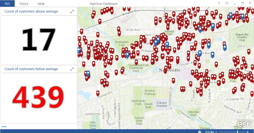
A1: Very few of the ArcGIS for Water Utilities solutions require/or use python. The only ones that require it are High/Low Water Consumption, Visualize Customer Service Calls, Discover Consumption Anomalies, and Generate Water Reports - the other 30+ solutions do not. You have the option to use python to set up the Model Organziation but you could do it manually if you want.
- Q2: Is this session recorded and available so we can pass along to other individuals?
A2: Yes, this Meetup was recorded and will be posted for all to view here; .
- Q3: Can you attach multiple photos?
A3: Yes.
- Q4: If we use BlueReview, where does our ticket information reside, including resolution, notes, pictures?
A4: All of your ticket information is easily accessible within BlueReview, and stored safely in the cloud. At anytime BlueReview can provide you with an exported set of all your data and files.
- Q5: If using Blue Review and AGOL together, does each locator need to have a 'Named User' account with AGOL?
A5: Yes, each BlueReview user requires a name user in an ArcGIS Online organization.
- Q6: Does Blue Review work in an offline mode?
A6: BlueReview’s offline/disconnect mode is currently in beta on the web version and in development for native mobile apps.
- Q7: How does this interact w/Hyland (OnBase) Document Management Software?
A7: Currently BlueReview does not integrate with any document management systems. However, the capability to integrate document management software is possible via our integrated solution with Cityworks or our REST API.
- Q8: So what's the cost of this BlueReview software?
A8: $5,000 a year up to 25 users.
- Q9: Excellent session and great job Howie, Dave, Jason and the BR team. When can we discuss CIP?
A9: We will put CIP on the list of topics.
- Q10: Can the user groups and permissions take advantage of existing Windows active directory group membership?
A10: Yes, you can federate ArcGIS with your identity store. If using active directory - it requires Active Directory Federation Services. This is configured in Enterprise Logins in the ArcGIS Online Administration tools.
- Q11: Blue Review: can you search for previously completed tickets by map location?
A11: Yes.
- Q12: Do you have experience with implementing this functionality in Europe?
A12: At this time, we do not have any customers in Europe, but we are happy to talk and explore the possibilities! We have worked outside the continental U.S. (Guam) and are currently discussing opportunities in Canada and Australia.
- Q13: What is the best way to store links to engineering drawings so that staff can click on a pipe and retrieve the correct engineering drawings.
A13: Depending on where your files reside and your GIS capabilities, engineering drawings, documents, or other files could be stored in ArcGIS for Server or ArcGIS Online or linked to from a cloud file management system. If you would like specific details, we can provide individual consultations on possible solutions.
- Q14: Very Nice, BlueReview! Question - Where is data stored, and photos?
A14: Data and photos are stored securely in BlueReview’s cloud database and backed up to redundant servers. No need for additional hardware or set up for onsite hosting. Up to 10 GB of data storage is included in your subscription along with 10-year data backup.
- Q15: You have hosted Server and Hosted Feature Classes do you offer hosted ArcMap Desktop?
A15: We currently do not host ArcMap in the cloud for customers.
- Q16: It would be nice to learn more about the mobile applications for valve and hydrant maintenance.
A16: Thank you, we will add it to the this of topics for subsequent Meetups.
- Q17: What is the cost of adding Blue Review to a current Esri mapping system?
A17: BlueReview is $5,000 a year up to 25 users. If you already own an ArcGIS Online organization and can provide BlueReview users with a named user it does not require any other Esri licensing.
- Q18: So to utilize these solutions we are going to need named user accounts for most of our users regardless of whether we use Portal or ArcGIS Online?
A18: Yes, both ArcGIS Online and Portal for ArcGIS Server are licensed by the named user.
- Q19: How are the reports done in Blue Review?
A19: Customers can access and produce reports of ticket activity (image files are not yet available). Reporting data can also include any custom fields created by the customer. Report information is readily accessible in BlueReview and can be exported in CSV format.
- Q20: Is there Windows 7 App available?
A20: The web-based version of BlueReview is optimized for mobile devices, including Windows 7 and Android. We currently offer native iOS apps for iPad and iPhone. Because all versions of BlueReview use the same REST API, performance of the native app and web app are similar.
- Q21: Portal? How does it work if we have to use in-house where we have ArcGIS server and publish maps internally?
A21: The most common deployment pattern for ArcGIS Online is a hybrid pattern, meaning that both ArcGIS Online and your on-premises ArcGIS Server(s) are used together. You can add an "item" in ArcGIS Online that acts as a pointer to your on-premises service(s), these services can then be used in your web maps. See Appendix C in the white paper for more information on this deployment pattern.
- Q22: Can individuals with 'user' level permissions create apps and solutions on an organization's ArcGIS Online site?
A22: Yes, and 'user' roles are configurable to create custom roles that allow organizations to manage user permissions settings.
- Q23: Is portal the same as web adapter, or is it another software that needs to be purchased?
A23: The Web Adapter is technology that connects your web server to your ArcGIS server (included with ArcGIS for Server). Esri portal technology is cloud-based (ArcGIS Online) or on-premisis (Portal for ArcGIS Server) collaborative content management system for maps, apps, data, and other geographic information. It is common for water utilities to leverage on-premises services (from ArcGIS Server) with ArcGIS Online. When doing this, users off the network will need access to the on-premises servers; this access it typically provided through VPN or Reverse Proxy. The Web Adapter can function as the Reverse Proxy on the Web Server to access the on-premises ArcGIS Servers - see Appendix C in the white paper for more information.
- Q24: How much coordination is required from the state 811?
A24: Coordination is minimal. Typically, all we need is your authorization (an email is usually sufficient) to receive tickets on your behalf. BlueReview requires tickets in XML or similar format.