- Home
- :
- All Communities
- :
- Industries
- :
- Water Resources
- :
- Water Resources Questions
- :
- Watershed Delineation-Multiple Culverts
- Subscribe to RSS Feed
- Mark Topic as New
- Mark Topic as Read
- Float this Topic for Current User
- Bookmark
- Subscribe
- Mute
- Printer Friendly Page
Watershed Delineation-Multiple Culverts
- Mark as New
- Bookmark
- Subscribe
- Mute
- Subscribe to RSS Feed
- Permalink
ArcGIS Pro 2.6
Hi All- I am stuck with delineating a watershed. I have archydro toolbox downloaded and I use it as much as possible instead of spatial analyst. I have approximately 40 culverts along a 15mile length of road that have been 'burned' into a DEM. I have snapped them to the stream link, and I ensured all streams crossed the road/were nearby the culverts prior to creating the streamlink (number of cells defined at 1500). Catchment, adjoint catchment, drainage line, and drainage points all look to be correct.
When I use Point Delineator, it chooses a single culvert point and delineates a tiny subwatershed (even smaller than the catchment polygon). When I use Watershed Delineation, it just cycles between "droping id" to "processed 0 features" to "final selection" to "sampling" to "100%" and back. It never finishes, and this has ran for three plus hours with no results.
Does anyone know of a work around, so that I can get an entire watershed, that includes majority of the catchments, but at least the main stream? Do I need to define a larger cell size for a new stream link and then delineate the watershed from that stream? I just need to make sure that all the possible flow is entering the culverts, and I do not want to limit the potential area by creating to large of a stream line.
- Mark as New
- Bookmark
- Subscribe
- Mute
- Subscribe to RSS Feed
- Permalink
Have you filled sinks? If not, that would be the step you need to do after burning streams and before flow direction.
- Mark as New
- Bookmark
- Subscribe
- Mute
- Subscribe to RSS Feed
- Permalink
Hi Mark--- yes that was the firs step after burning the DEM with the culverts.
Are you suggesting that I need to additionally burn the streams into the DEM as well?
- Mark as New
- Bookmark
- Subscribe
- Mute
- Subscribe to RSS Feed
- Permalink
If the DEM has resolution to define the streams, you wouldn't have to burn the streams into the DEM. However, if the streams are not well defined by the DEM (the cell size is large enough to "bridge" the stream and on a color ramp of the DEM [or hillshade of the DEM] the streams are not clearly visible), you may need to burn in the streams.
- Mark as New
- Bookmark
- Subscribe
- Mute
- Subscribe to RSS Feed
- Permalink
This is my 3m DEM--- but as you can see the northern portion of it is pretty flat. Mostly just creeks/wetlands with no major tributaries.
- Mark as New
- Bookmark
- Subscribe
- Mute
- Subscribe to RSS Feed
- Permalink
I'm still in ArcMap, not Pro. With either version you should be able to symbolize the color ramp on the DEM to view the statistics "From Current Display Extent" (see first image). This allows you to see the subtle differences in the DEM no matter what your zoom level.
The second image below is a portion of our County DEM with this setting. The third image is a zoom in on what looks flat. The color ramp adjusts for the the data in that view revealing more detail.
You should be able to study parts of your DEM to tell if burning the streams is needed, especially where you are getting the small watersheds.
Of course, make sure the right rasters are being used by the delineation tool.
Portion of our County DEM
Zoomed in on the red square.
- Mark as New
- Bookmark
- Subscribe
- Mute
- Subscribe to RSS Feed
- Permalink
in Pro the setup is slightly different....
but-- This is the zoomed out:
this is the zoomed in DEM:
So, this is why I am at an utter loss and confusion! I feel like all the steps I am taking SHOULD yield results. Yet, for some reason- I am coming up empty handed. And like you said earlier, if I am getting correct adjoint catchments, then the data is there and pulling appropriately.
The only issue I see here is the culverts- that the points themselves are causing a problem If the DEM is not a problem, the streams are not a problem, the catchments are not a problem. It has to be the culvert points. Snapped to the streams initially, or not and done during the watershed delineation, same lack of results.
- Mark as New
- Bookmark
- Subscribe
- Mute
- Subscribe to RSS Feed
- Permalink
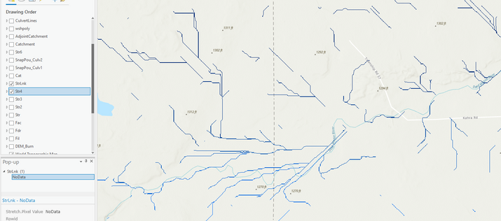
After digging even deeper into the data, I may have discovered the problem. For some reason, my stream and stream links are not connecting the paths together- and when I turn on the drainage line layer- that feature class is just line data of these two rasters overlapping.
So how do i get one solid stream network to appear, and not have the mainstream itself become disconnected? (Str was a cell size of 500, Str2 was 1000, Str3 was 1200, and Str4 was 1500; StrLnk was created from Str4)


