Turn on suggestions
Auto-suggest helps you quickly narrow down your search results by suggesting possible matches as you type.
Cancel
- Home
- :
- All Communities
- :
- Industries
- :
- Water Resources
- :
- Water Resources Questions
- :
- Help me understand -- Catchments/stream definition...
Options
- Subscribe to RSS Feed
- Mark Topic as New
- Mark Topic as Read
- Float this Topic for Current User
- Bookmark
- Subscribe
- Mute
- Printer Friendly Page
Help me understand -- Catchments/stream definition/stream segmentation
Subscribe
7913
3
04-15-2014 08:22 AM
04-15-2014
08:22 AM
- Mark as New
- Bookmark
- Subscribe
- Mute
- Subscribe to RSS Feed
- Permalink
I've been using ArcHydro for 6-8 years now, doing watershed modeling for drainage projects. While I understand the majority of what the software is doing as I work through the process, I've never been able to fully wrap my head around a couple of the steps - mainly being the stream definition/stream segmentation process, and how that relates to final catchments.
I understand that in the stream definition process, the smaller number you use for "number of cells to define stream" will result in a more defined stream network, tracing further up 'feeder' streams; while a larger number used will create a stream network of only the larger flow areas. I think where I ultimately get confused is when I get to generating catchments.
For the work I do, I am typically working with watersheds in the 5,000-20,000 acre range, and because of the type of work we are doing, when I get to the stream definition step, I use a definition area of 0.008 km^2 (~2 acres) to get the stream network to generate to the detail we want. Now, the way I look at it, I would expect with a ~2 acre definition used in the stream definition, when catchments are generated, in a given 40 acre tract of ground, I would find somewhere in the neighborhood of 20 catchments. Instead, I am finding a half dozen or so catchments, varying in size, but some as large as 15-18 acres. I can't figure out how to reconcile this in my head - or worse, how to explain it to my boss.
I think I understand correctly that the stream definition threshold sets the minimum area flowing to a given point to start a stream -- but how does the stream segmentation take off after that? How are catchments along a long flow path broken up?
3 Replies
04-16-2014
08:16 AM
- Mark as New
- Bookmark
- Subscribe
- Mute
- Subscribe to RSS Feed
- Permalink
As I understand it, the purpose behind catchments, drainlines, and adjointcatchments isn't to give you the right size of watersheds for your study. Their purpose is to be a network to make the delineation of watersheds faster.
Before use of the network databases, each watershed was delineated just using the flow direction grid. On the then much slower computers, this was painfully slow. Once someone figured out how to use the network functions for hydrology, the delineation of watersheds was amazingly fast compared to the old way. I heard that when it was demonstrated at a conference, it was so much faster than normally experienced, the audience thought it was a trick! The HydroID, DrainID, and NextDownID in the catchments, drainlines, and adjointcatchments are all related to the network database .
Instead of focusing on the catchments, etc., you could assume they are a background "model" on which you then set batch points at the specific locations you need to study. Then the batchpoints, subwatersheds/watersheds etc. become the working layers you do you analysis with. HEC-GeoHMS has some nice tools that compliment Arc Hydro.
That's my understanding and approach.
Btw, the stream definition has been puzzling to me too. I think the problems come because the flow accumulation can jump dramatically at "junctions" in the flow direction grid. For example, if you have one subshed with 299 cells, and another with 299 cells and you set number of cells to define the stream at 300, the number jumps from 299 to 599 (including the cell you are now on) and you miss the target.
04-23-2014
08:37 PM
- Mark as New
- Bookmark
- Subscribe
- Mute
- Subscribe to RSS Feed
- Permalink
This post was from a few weeks ago but since it is something I've just been trying to deal with, thought I'd attempt to give an explanation.
My understanding of this is that while FAC determines what gets classified as a stream, stream segmentation (and thus the generation of drainage points and catchments) is essentially a function of the branching of that network.
You might set a relatively large FAC threshold so that only major rivers are defined - but if that major river network has segments that are quite dendritic in a short stretch, you end up with a drainage point at every convergence, and many catchments that are very small compared to the drainage area used to initially define a stream.
The flip side of this is that if the generated drainage network has no feeder streams or convergences for a long stretch, there will be no stream segmentation along it, no drainage points midway, and Arc Hydro will delineate you one main, large catchment - instead of nice equal area divisions of your watersheds!
EDIT: I did this example before I re-read the post and realised that you said you were getting surprisingly few catchments large catchments, not many small ones. Will leave it for illustration of the segmentation and catchment delienation process however.
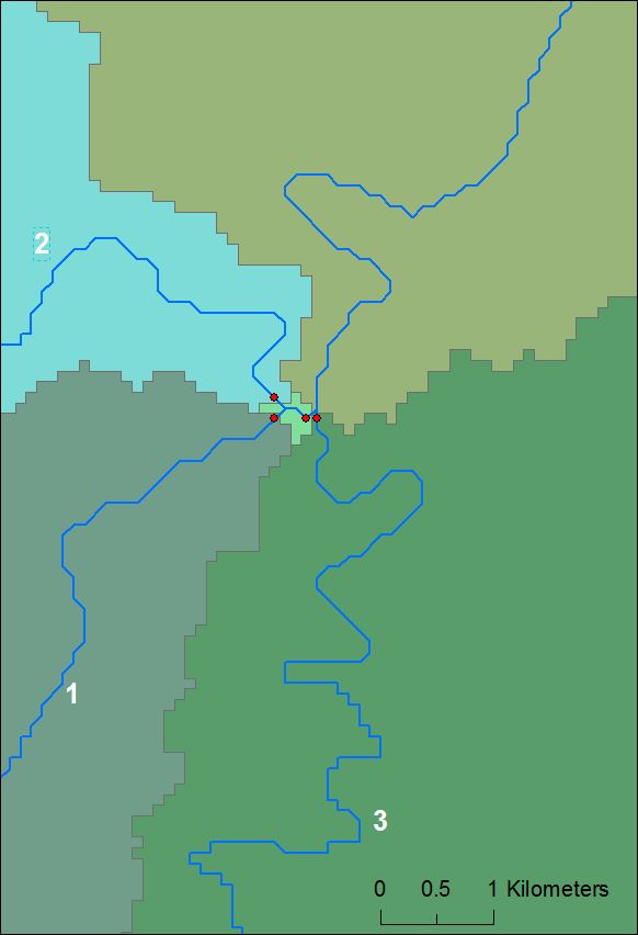
For example, in the image attached I used a large FAC threshold to define streams (24 000 cells at 93 x 93 m, so ~ 207 km2. Segmentation is performed at each convergence and a drainage point generated (red dots). Segments one and two converge first, then the third happens to converge a short way downstream. The result is catchments of reasonably appropriate size upstream of segments 1, 2 & 3 before they converge. However, just upstream of where 1 & 2 converge with 3 is a tiny catchment < 1 km2 - which is an area far far below the sort of drainage area used to define the streams initially.
[ATTACH=CONFIG]33316[/ATTACH]
Hope this helps - note I could be wrong about how it works but this seems to make sense in the context of results I've had.
To avoid or control this, I guess you would need to manually select or set drainage points rather than Arc Hydro delineate automatically on all drainage points. If you wanted to break up your large catchment into smaller ones, then I'd suggest setting more drainage/delineation points along the stretch of stream that needs to be broken up. As Mark said above - this is where setting batch points or using other tools comes in handy, rather than using the automatically generated catchments/drainage points as your final delineation.
Cheers
Mal
My understanding of this is that while FAC determines what gets classified as a stream, stream segmentation (and thus the generation of drainage points and catchments) is essentially a function of the branching of that network.
You might set a relatively large FAC threshold so that only major rivers are defined - but if that major river network has segments that are quite dendritic in a short stretch, you end up with a drainage point at every convergence, and many catchments that are very small compared to the drainage area used to initially define a stream.
The flip side of this is that if the generated drainage network has no feeder streams or convergences for a long stretch, there will be no stream segmentation along it, no drainage points midway, and Arc Hydro will delineate you one main, large catchment - instead of nice equal area divisions of your watersheds!
EDIT: I did this example before I re-read the post and realised that you said you were getting surprisingly few catchments large catchments, not many small ones. Will leave it for illustration of the segmentation and catchment delienation process however.
For example, in the image attached I used a large FAC threshold to define streams (24 000 cells at 93 x 93 m, so ~ 207 km2. Segmentation is performed at each convergence and a drainage point generated (red dots). Segments one and two converge first, then the third happens to converge a short way downstream. The result is catchments of reasonably appropriate size upstream of segments 1, 2 & 3 before they converge. However, just upstream of where 1 & 2 converge with 3 is a tiny catchment < 1 km2 - which is an area far far below the sort of drainage area used to define the streams initially.
[ATTACH=CONFIG]33316[/ATTACH]
Hope this helps - note I could be wrong about how it works but this seems to make sense in the context of results I've had.
To avoid or control this, I guess you would need to manually select or set drainage points rather than Arc Hydro delineate automatically on all drainage points. If you wanted to break up your large catchment into smaller ones, then I'd suggest setting more drainage/delineation points along the stretch of stream that needs to be broken up. As Mark said above - this is where setting batch points or using other tools comes in handy, rather than using the automatically generated catchments/drainage points as your final delineation.
Cheers
Mal
08-18-2022
09:52 PM
- Mark as New
- Bookmark
- Subscribe
- Mute
- Subscribe to RSS Feed
- Permalink
In simple terms, the answer for the original question is this:
The user controls the minimum drainage area required to form the beginning of a reach. This is the same as defining the average areas of the headwater sub-basins. This is done when you set the threshold in the stream definition.
After that, the user does not have control over the size of the downstream sub-basins, because the distance between reaches, or streams, is what drives it. Hence, the downstream sub-basins can be much larger, or much smaller than the initial threshold set on the stream definition.