- Home
- :
- All Communities
- :
- Industries
- :
- Water Resources
- :
- Water Resources Questions
- :
- Re: HEC-GeoHMS: Watershed could not be delineated ...
- Subscribe to RSS Feed
- Mark Topic as New
- Mark Topic as Read
- Float this Topic for Current User
- Bookmark
- Subscribe
- Mute
- Printer Friendly Page
HEC-GeoHMS: Watershed could not be delineated from the outlet point!
- Mark as New
- Bookmark
- Subscribe
- Mute
- Subscribe to RSS Feed
- Permalink
- Report Inappropriate Content
I got the following problem by working with your HEC-GeoHMS program.
I want to analyze the watershed that drains to the stream gage. So I select in the HEC-GeoHMS toolbar --> Project Setup --> Start New Project.
I defined a new project and named an outlet point.
Then I wanted to generate a project (--> Project Setup --> Generate Project).
Now I get the following error message: Watershed could not be delineated from the outlet point!
This problem occurs in ArcGIS software 10.2.2 and 10.4. I have done all steps like in the User’s Manual Chapter 13.
Is there any solution for this problem?
- Mark as New
- Bookmark
- Subscribe
- Mute
- Subscribe to RSS Feed
- Permalink
- Report Inappropriate Content
I have the same problem. I am Using Arcgis 10.2.2
- Mark as New
- Bookmark
- Subscribe
- Mute
- Subscribe to RSS Feed
- Permalink
- Report Inappropriate Content
Have you solve the problem?
- Mark as New
- Bookmark
- Subscribe
- Mute
- Subscribe to RSS Feed
- Permalink
- Report Inappropriate Content
I had the same problem. Verify your AdjointCatchment, for me it was empty! And not forget that the layers should be save in the Geodatabase.
- Mark as New
- Bookmark
- Subscribe
- Mute
- Subscribe to RSS Feed
- Permalink
- Report Inappropriate Content
One thing that may be contributing to this is the presence of spaces and a potentially restricted character (the dash) in the file paths. Remedy this for your Flow Direction Grid by adding underscores to Neuer Ordner where there are spaces and just to be safe remove the dash. Check all your other data to see if this is an issue.
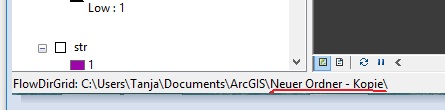
Raster processes have much more specific file naming conventions than typical GIS files, so this could be what is causing the problem. Unfortunately, there is not an explicit error that will come up advising the user that spaces and restricted characters are present and therefore causing a problem.
Output raster formats and names—ArcGIS Help | ArcGIS Desktop
Chris Donohue, GISP
- Mark as New
- Bookmark
- Subscribe
- Mute
- Subscribe to RSS Feed
- Permalink
- Report Inappropriate Content
I was also facing the same problem, but then I have installed Arc-GIS 10.1 and along with the Arc-Hydro tools 10.1 and Hec-GeoHMS 10.1. Also, try to create the input files from Arc-Hydro tools and then proceed directly to the step where you have to create project ("Project Setup"). For that, initially you have to input all the files in the Data Management of the Project Setup toolbar.