- Home
- :
- All Communities
- :
- Industries
- :
- Water Resources
- :
- Water Resources Questions
- :
- DEM reconditioning with Arc Hydro
- Subscribe to RSS Feed
- Mark Topic as New
- Mark Topic as Read
- Float this Topic for Current User
- Bookmark
- Subscribe
- Mute
- Printer Friendly Page
DEM reconditioning with Arc Hydro
- Mark as New
- Bookmark
- Subscribe
- Mute
- Subscribe to RSS Feed
- Permalink
Good afternoon,
First of all I would to apologize if this question has already been asked. I'm using the "DEM reconditioning" tool in #Arc Hydro to burn in streams into my DEM. The tool runs fine and gives me an output which however, as far as I have understood, isn't correct. The problem is that the resulting "AGREE" raster only shows data along the streams instead of the entire DEM raster. What I believe I should be getting is a raster very similar to my original DEM but with burnt in steams (lower pixel values along the streams' course).
Do you have any idea what may be causing the problem?
Thanks so much in advance for your help.
Alex.
- Mark as New
- Bookmark
- Subscribe
- Mute
- Subscribe to RSS Feed
- Permalink
Interesting. I've had the processing extents off before which will clip the results vertically and/or horizontally due to a reduced processing extent. I don't think I've ever had it "mask" the results to the AGREE Streams.
Are the elevations in the resulting AGREE DEM valid? All I can think of is maybe the Raw DEM layer that the tool is defaulting to is not the "rawdem" raster. When I use Arc Hydro I always use the default raster, dataset names. This saves some time and reduces some errors.
A while ago I couldn't get the DEM Reconditioning to work. I now don't recall if it crashed or did what you are experiencing. In the end I developed my own Model Builder model to do that work. Took a bit to get the logic right and creates a bunch of intermediate rasters (likely the tool does too). It has worked well enough for me that I don't use that part of Arc Hydro. A screen shot of is is below.
At some point I'll try the DEM Reconditioning tool again. I'm learning Python bit by bit and may eventually turn to that. Python appears to have less problems than Model Builder. Also, I hear that ArcGIS Pro Model Builder will be more stable due to the 64 bit compatibility.
Mark

- Mark as New
- Bookmark
- Subscribe
- Mute
- Subscribe to RSS Feed
- Permalink
Dear Mark,
Thanks so much for your quick reply and for sharing your knowledge.
So, funny thing: this morning I moved my data onto my C drive (I was working on a server earlier) and the tool (DEM reconditioning) worked perfectly! As you mentioned Mark, earlier the tool was returning correct values for the streams but it was also masking everything outside (pixels not corresponding to streams came up as "No data").
Not sure what I was doing wrong but I noticed that other operations such a simple raster clip operation using a polygon as a mask, weren't working either.
Thanks again for the help!
Alex.
- Mark as New
- Bookmark
- Subscribe
- Mute
- Subscribe to RSS Feed
- Permalink
Glad its working for you! Moving data to the C:drive was "revolutionary" in my learning/experience in Arc Hydro. If you haven't been there, go to ArcHydro Problem Solvers. I started that thread to share/record my learning experience and others' contributions are also there.
Best,
Mark
- Mark as New
- Bookmark
- Subscribe
- Mute
- Subscribe to RSS Feed
- Permalink
Hi Mark,
Thanks, I'll keep working on the C drive then. I had seen the ArcHydro problem Solvers but will have a better look. But I'll also take the chance to ask you another question if you don't mind: it seems that when running hydrological analyses with ArcHydro on my entire DEM I get slightly different results than when I run the analyses on a much smaller portion of the DEM that I clipped from the original DEM. For example stream delineation seems to be much more accurate on the subsample than the entire dataset (I can see this clearly by overlaying a hillshade model). I sthis something that you've experienced and do you know why it might be happening? Would you suggest to run the analyses and smaller portions at a time?
Thanks so much again.
Regards,
Alex.
- Mark as New
- Bookmark
- Subscribe
- Mute
- Subscribe to RSS Feed
- Permalink
Alex,
I haven't noticed that before and it isn't something I'd expect. In dealing with rasters of different cell size (not in Arc Hydro) I've seen some strange results. In Arc Hydro I would always want/expect the subsequent rasters to have cell sizes the same, and be lined up with, the rawdem.
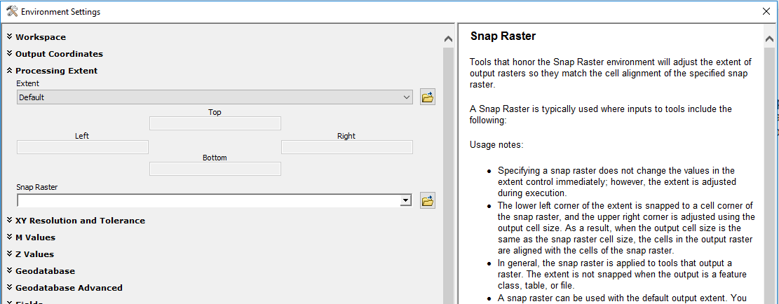
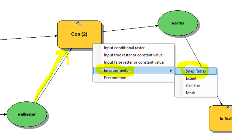
Sometimes I will make sure that the "Snap Raster" is set as the rawdem so that the resulting processed rasters "line up" with the rawdem. If using model builder you can do this. Otherwise you use the Geoprocessing>Environments menu and dialogue. Images below.
Best,
Mark
ArcMap

Model Builder (use "Connect" tool/pointer and drag line from raster to yellow box "tool", choose Environments, choose Snap Raster)
- Mark as New
- Bookmark
- Subscribe
- Mute
- Subscribe to RSS Feed
- Permalink
Thanks so much again Mark. I’ll take the chance to ask for your opinion on some analyses I’m planning to run (hope it’s ok on the same thread). I will need to investigate potential wetland locations within county borders. I’m only interested in certain parts of the county hence I would rather not run the analyses using the DEM for the entire county. Instead I was thinking of limiting the analyses (in Arc Hydro) to the sub-basins (watersheds) the area of interest fall within. These sub-basins have been calculated by another authority and are provided in shape file form. So essentially I will use Arc Hydro to draw smaller basins within the larger ones I describe above. My question is: is this approach reasonable? How important is the way a DEM for hydrological analyses is delimited? Is it better to “clip out” square or rectangular portions of the original DEM or is my approach using larger sub-basins as a clipping mask better?
Also do you have any opinion on the "Adjust flow direction in lakes" function and how important is that?
Thanks again.
Alex.
- Mark as New
- Bookmark
- Subscribe
- Mute
- Subscribe to RSS Feed
- Permalink
Alex,
Sorry to reply so late!
I routinely use the Extract by Mask tool to limit the area I'm analyzing. It really reduces the processing time. To keep things consistent throughout my county, I have a "master" agreestreams, innerwalls and outerwalls datasets in a geodatabase. This allows me to break up the watersheds as needed but keep the same features for modifying the DEM regardless of where I'm working.
I don't use the "Adjust flow direction in lakes" function. What I do is put an agreestreams feature that goes through the lake an then to the outlet. I also put an innerwalls line across the dam. This allows me to put a batch point at the mouth of the lake or reservoir and perform watershed delineation, etc. at that point.
Hope this helps,
Mark
- Mark as New
- Bookmark
- Subscribe
- Mute
- Subscribe to RSS Feed
- Permalink
Hi Mark,
Thank you for your unreserved replies to all the posts here.
Could you provide the model builder screen shoot with good quality so that we can easily adopt and solve the problem.
Thanks.