- Home
- :
- All Communities
- :
- Industries
- :
- Water Resources
- :
- Water Resources Questions
- :
- Creating Curve Number Raster
- Subscribe to RSS Feed
- Mark Topic as New
- Mark Topic as Read
- Float this Topic for Current User
- Bookmark
- Subscribe
- Mute
- Printer Friendly Page
Creating Curve Number Raster
- Mark as New
- Bookmark
- Subscribe
- Mute
- Subscribe to RSS Feed
- Permalink
I'm researching how to create a curve number CN raster. I'm calculating runoff depth in urban areas. Does the Arc Hydro Tools team have a workflow that I can follow similar to the terrain pre-processing workflow case studies? Those workflows in the case studies are very easy to follow. I've reviewed a few videos on creating CN and each has slightly different workflows.
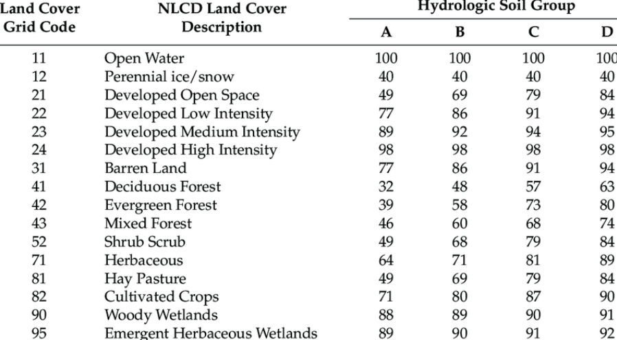
Additionally, is there a curve number CN by NLCD land cover lookup table? Doing some investigation of various samples on the Internet, I'm seeing slightly different numbers. I've attached a screenshot of table I was planning to use. Thank you kindly for any advice and direction!
Solved! Go to Solution.
Accepted Solutions
- Mark as New
- Bookmark
- Subscribe
- Mute
- Subscribe to RSS Feed
- Permalink
John,
Arc Hydro has a tool called "Generate CN Raster" (in the H&H Modeling -> Utility toolset). It takes three inputs - DEM (used for rasterization of the final CN raster product), land use/soil polygon feature class, and CN lookup table that identifies CN value for combination of LU/soil type. Help for the tool has description of the fields that need to be in FC and table for the tool to work. Please review, and see if that works for you.
As far as the CN per NLCD values goes, you have to be very careful. CN values are LOCAL, so the same land use/soil combination can (and should) have different values for different geographic locations - similar, but different. That is why you will see different numbers depending on the literature you are using as a reference. In the US, local NRCS offices maintain such local information (and some other agencies might use their own - e.g. in a hydrology manual for a county). That was one of the drivers in our tool design - we wanted to provide you with the option to specify your own table and through it control the assignment of CN values.
Dean
- Mark as New
- Bookmark
- Subscribe
- Mute
- Subscribe to RSS Feed
- Permalink
John,
No need - the terrain is used only as a reference for extent, snap raster, and cell size.
Dean
- Mark as New
- Bookmark
- Subscribe
- Mute
- Subscribe to RSS Feed
- Permalink
John,
The Pct* fields indicate percentage (0-100) of specific soil type * in the polygon you are representing. Ideally, the sum of all the Pct* fields per polygon will add up to 100. Tool help has explanation on how the numbers are used. What numbers to actually put in will greatly depend on you location - this goes both for the CN as well as Pct* numbers. It might also depend on the type of modeling you are doing (e.g. if you are modeling hydrologic system response to year 2050 conditions you might use different numbers than if the modeling is for today conditions - in addition to different land use polygon extents). There are some "generic" numbers in the literature and online resources (search "hydrologic soil group") that you can use as a starting point, but you really need to be careful in using them as typically they are not correct for your specific geography. Living Atlas has some good resources if you want to use "global" datasets.
Dean
- Mark as New
- Bookmark
- Subscribe
- Mute
- Subscribe to RSS Feed
- Permalink
John,
Arc Hydro has a tool called "Generate CN Raster" (in the H&H Modeling -> Utility toolset). It takes three inputs - DEM (used for rasterization of the final CN raster product), land use/soil polygon feature class, and CN lookup table that identifies CN value for combination of LU/soil type. Help for the tool has description of the fields that need to be in FC and table for the tool to work. Please review, and see if that works for you.
As far as the CN per NLCD values goes, you have to be very careful. CN values are LOCAL, so the same land use/soil combination can (and should) have different values for different geographic locations - similar, but different. That is why you will see different numbers depending on the literature you are using as a reference. In the US, local NRCS offices maintain such local information (and some other agencies might use their own - e.g. in a hydrology manual for a county). That was one of the drivers in our tool design - we wanted to provide you with the option to specify your own table and through it control the assignment of CN values.
Dean
- Mark as New
- Bookmark
- Subscribe
- Mute
- Subscribe to RSS Feed
- Permalink
Hello, Dean!
Thank you for your advice! Do I have to run terrain pre-processing on the DEM prior to using it in the Generate CN Raster tool?
John
- Mark as New
- Bookmark
- Subscribe
- Mute
- Subscribe to RSS Feed
- Permalink
John,
No need - the terrain is used only as a reference for extent, snap raster, and cell size.
Dean
- Mark as New
- Bookmark
- Subscribe
- Mute
- Subscribe to RSS Feed
- Permalink
Thank you, Dean! I greatly appreciate your time!
John
- Mark as New
- Bookmark
- Subscribe
- Mute
- Subscribe to RSS Feed
- Permalink
The Generate CN Raster tool requires (5) attribute fields that must be populated: LandUse, PctA, PctB, PctC, PctD. Can you please advise what values to populate these fields with? LandUse, I suspect land classification code. I'm not sure about the Pct fields.
- Mark as New
- Bookmark
- Subscribe
- Mute
- Subscribe to RSS Feed
- Permalink
John,
The Pct* fields indicate percentage (0-100) of specific soil type * in the polygon you are representing. Ideally, the sum of all the Pct* fields per polygon will add up to 100. Tool help has explanation on how the numbers are used. What numbers to actually put in will greatly depend on you location - this goes both for the CN as well as Pct* numbers. It might also depend on the type of modeling you are doing (e.g. if you are modeling hydrologic system response to year 2050 conditions you might use different numbers than if the modeling is for today conditions - in addition to different land use polygon extents). There are some "generic" numbers in the literature and online resources (search "hydrologic soil group") that you can use as a starting point, but you really need to be careful in using them as typically they are not correct for your specific geography. Living Atlas has some good resources if you want to use "global" datasets.
Dean
- Mark as New
- Bookmark
- Subscribe
- Mute
- Subscribe to RSS Feed
- Permalink
Thank you! I see the Arc Hydro Docs documentation via esrips.github.io. I completely overlooked this resource. Fantastic! Tool Documentation section...🙏 Thanks again for your time! I greatly appreciate it!
John