- Home
- :
- All Communities
- :
- Industries
- :
- Water Resources
- :
- Water Resources Questions
- :
- An issue regarding Flow Direction from a PhD stude...
- Subscribe to RSS Feed
- Mark Topic as New
- Mark Topic as Read
- Float this Topic for Current User
- Bookmark
- Subscribe
- Mute
- Printer Friendly Page
An issue regarding Flow Direction from a PhD student
- Mark as New
- Bookmark
- Subscribe
- Mute
- Subscribe to RSS Feed
- Permalink
Hello,
I am a PhD student in the UK and my project currently involves assessing how a certain species selects habitats. One variable of mine that is incredibly important (towards the species) regards water systems (mostly rivers and streams). So, I have a DEM (30 metre resolution) and from that, I was able to create a river and stream map for the area (as there is no available data on these variables for that region). Here is exactly what I did:
- got the DEM (30 m resolution and used fill)
- used the fill data to get flow direction
- flow direction to flow accumulation
- used raster calculator to assess accumulation grid (log10 ("accumulation grid data")
- took that log10 accumulation data (thus showing the smaller drainage areas)
- considered hill slope via raster calculator CON(log10data >=2, log10data)
So, that actually worked for the most part. I forgot to mention that there is an old map with river and stream systems and they match up very well. However! There is one huge issue. It turns out..the saltpans in the area (which I guess are very flat, although, I never visited them) have been completely distorted. When I complete the watershed analysis, it essentially, creates a huge (and weird) region where the saltpans are filled. I have asked a GIS specialist at my department and he was unsure how to fix this. my projections are correct, and in so far, I cannot think on how to fix this. I'v attached some photos (and links to photos) below that display my results. I have been pondering about this for quite some time and any suggestions would be incredibly appreciated.
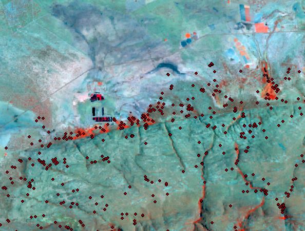
these are the saltpans
[here is the flow direction pic]http://i.imgur.com/ukuOEoT.jpg[/img]
- Mark as New
- Bookmark
- Subscribe
- Mute
- Subscribe to RSS Feed
- Permalink
Thank you so much!
could you message me your email address?
- Mark as New
- Bookmark
- Subscribe
- Mute
- Subscribe to RSS Feed
- Permalink
Hi Alec
If you can send me an LinkedIn invite @ Peter Wilson I'll accept and send you my details. I don't want to post my work email address on the net.
Regards
- Mark as New
- Bookmark
- Subscribe
- Mute
- Subscribe to RSS Feed
- Permalink
Hi Paul
I've not heard back from you, have you come right with the following?
- « Previous
-
- 1
- 2
- Next »
- « Previous
-
- 1
- 2
- Next »