Turn on suggestions
Auto-suggest helps you quickly narrow down your search results by suggesting possible matches as you type.
Cancel
- Home
- :
- All Communities
- :
- Industries
- :
- Transportation
- :
- Transportation Questions
- :
- Re: Sea distance calculation
Options
- Subscribe to RSS Feed
- Mark Topic as New
- Mark Topic as Read
- Float this Topic for Current User
- Bookmark
- Subscribe
- Mute
- Printer Friendly Page
Sea distance calculation
Subscribe
8153
2
02-16-2011 03:10 AM
02-16-2011
03:10 AM
- Mark as New
- Bookmark
- Subscribe
- Mute
- Subscribe to RSS Feed
- Permalink
Hello, i was asked to create a sea distance calculator for my work (epidemiology departament at National health Ministery in Argentina).
The objective is to calculate distance between ports first and time in days for each distance depending on vessel speed.
I dont need anything greatly detailed (depth of water is not an issue and so ).
I dont really have a clue on how to start. I have ports lat-long, thats all.
The objective is to calculate distance between ports first and time in days for each distance depending on vessel speed.
I dont need anything greatly detailed (depth of water is not an issue and so ).
I dont really have a clue on how to start. I have ports lat-long, thats all.
2 Replies
03-07-2011
08:39 AM
- Mark as New
- Bookmark
- Subscribe
- Mute
- Subscribe to RSS Feed
- Permalink
Howdy,
The ideal tool for this task would probably be using the Network Analyst tool, it is an Arc extension so depending on the version of ArcGIs you have you may not have access to it.
You can learn mopre about Network Anlayst in the desktop help:
http://help.arcgis.com/en/arcgisdesktop/10.0/help/index.html#//004700000001000000.htm
Does this sound like what you are trying to achieve?
03-08-2016
08:16 AM
- Mark as New
- Bookmark
- Subscribe
- Mute
- Subscribe to RSS Feed
- Permalink
I had meet the same problem , calculating distance from sea.
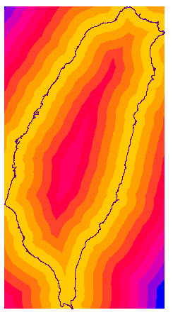
Here is my solution "Euclidean Distance"
put feature in and out put will be raster data.
If your input is line ,the result would calculate inside and outside.
