Turn on suggestions
Auto-suggest helps you quickly narrow down your search results by suggesting possible matches as you type.
Cancel
- Home
- :
- All Communities
- :
- Industries
- :
- Transportation
- :
- Transportation Questions
- :
- Navigator scale problem
Options
- Subscribe to RSS Feed
- Mark Topic as New
- Mark Topic as Read
- Float this Topic for Current User
- Bookmark
- Subscribe
- Mute
- Printer Friendly Page
Navigator scale problem
Subscribe
4940
7
08-27-2010 08:20 AM
08-27-2010
08:20 AM
- Mark as New
- Bookmark
- Subscribe
- Mute
- Subscribe to RSS Feed
- Permalink
When i type in a destination and hit the Navigate button, Navigator goes to the map and zooms in to a scale of 1:1. I have to hit the minus sign about 15 times before I finally see the streets around the vehicle.
How do I get it to stop zooming to such a high scale?
How do I get it to stop zooming to such a high scale?
7 Replies
08-27-2010
09:25 AM
- Mark as New
- Bookmark
- Subscribe
- Mute
- Subscribe to RSS Feed
- Permalink
The default scale it zooms to should definitely not be 1:1. Can you tell me which dataset you're using (Tele Atlas or NAVTEQ) and give me an example of an address which shows this behavior?
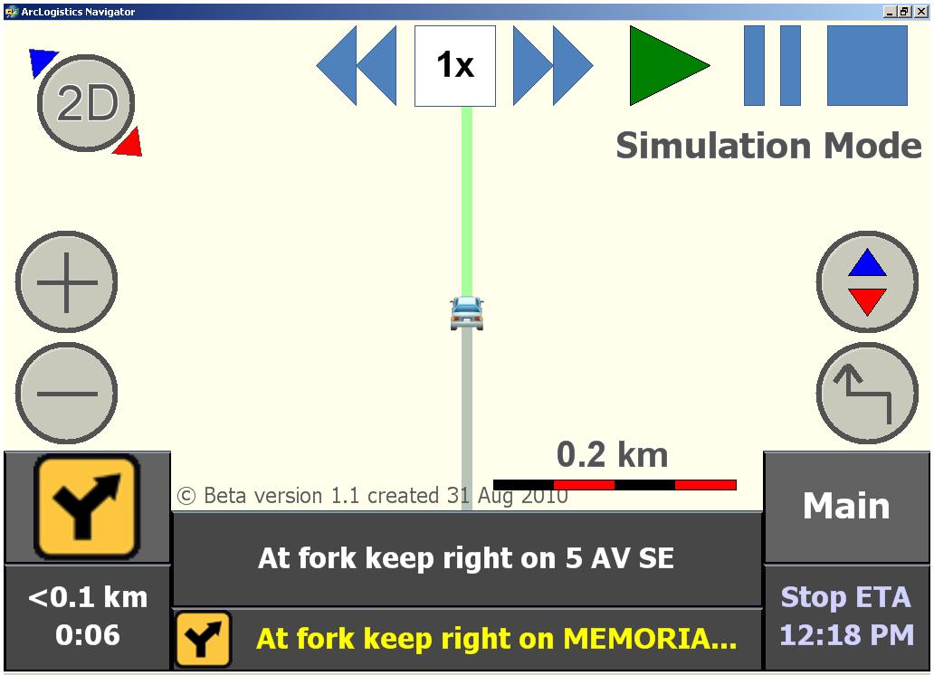
I've attached an image showing the default scale you should see when navigating between two stops.
Also, if you go into 2D mode, what number is displayed above the scale bar? Each time you hit 'Navigate', this should default back to .1 miles in 2d mode.
I've attached an image showing the default scale you should see when navigating between two stops.
Also, if you go into 2D mode, what number is displayed above the scale bar? Each time you hit 'Navigate', this should default back to .1 miles in 2d mode.
08-27-2010
01:52 PM
- Mark as New
- Bookmark
- Subscribe
- Mute
- Subscribe to RSS Feed
- Permalink
We're using our own data created by a service provider. I won't be able to give you more details until Monday.
08-27-2010
02:38 PM
- Mark as New
- Bookmark
- Subscribe
- Mute
- Subscribe to RSS Feed
- Permalink
Ok, I have a feeling that it may be data related then but we'll try to figure it out next week. Clicking the zoom out button 15x each time you route probably isn't very convenient.
09-01-2010
06:08 AM
- Mark as New
- Bookmark
- Subscribe
- Mute
- Subscribe to RSS Feed
- Permalink
There appears to be a problem with how Navigator is interpreting the map data. I you look at the attached files you will see the the scales are out of this world and inconsistant. Also, as I navigate a route using the similated GPS the scales fluctuate.
Please note the difference in scale values between Full scale at 600km and Usable Scale 13,500Km
Please note the difference in scale values between Full scale at 600km and Usable Scale 13,500Km
09-01-2010
07:49 AM
- Mark as New
- Bookmark
- Subscribe
- Mute
- Subscribe to RSS Feed
- Permalink
I'm almost positive this won't work with data that is built using metric measurements. I will confirm with those that build the data but I know even the Europe data is built using MPH and then converted.
Who built this data? Is there any specific reason you need to use custom data vs. off the shelf Tele Atlas or NAVTEQ products?
Who built this data? Is there any specific reason you need to use custom data vs. off the shelf Tele Atlas or NAVTEQ products?
09-01-2010
07:58 AM
- Mark as New
- Bookmark
- Subscribe
- Mute
- Subscribe to RSS Feed
- Permalink
Its being built by:
http://www.navigate.com.au/contact_us.htm
NAVIGATE Pty Ltd
Yes we need to route our inspectors to roads that are not yet built. Our data includes this. Is there a way that we could provide the data in MPH? Perhaps by changing our projection.
http://www.navigate.com.au/contact_us.htm
NAVIGATE Pty Ltd
Yes we need to route our inspectors to roads that are not yet built. Our data includes this. Is there a way that we could provide the data in MPH? Perhaps by changing our projection.
09-01-2010
08:10 AM
- Mark as New
- Bookmark
- Subscribe
- Mute
- Subscribe to RSS Feed
- Permalink
We know the guys at that company, I'll contact them and we'll figure something out. Thanks.