- Home
- :
- All Communities
- :
- Industries
- :
- Transportation
- :
- Transportation Questions
- :
- Re: How do I create a boundary points layer with u...
- Subscribe to RSS Feed
- Mark Topic as New
- Mark Topic as Read
- Float this Topic for Current User
- Bookmark
- Subscribe
- Mute
- Printer Friendly Page
How do I create a boundary points layer with updated Highway Postmile values?
- Mark as New
- Bookmark
- Subscribe
- Mute
- Subscribe to RSS Feed
- Permalink
I have a polyline layer for State Highways and a polygon layer of Urban Areas. I need to create a points layer where the highways intersect the boundaries of the Urban Areas.
Also, the highways layer has Postmile values in it. When I create the "boundary points" layer, I need to have updated Postmile values.
For example: If I have a Highway with Begin Postmile = 0 and End Postmile = 19, if the Highway intersects the boundary of the Urban Area at 6, then my Points layer should have fields looking like this:
BEGIN END
0 6
6 10
I have done something similar using another software but I'd like to think its simpler in ArcGIS.
Thanks,
Dan B
- Mark as New
- Bookmark
- Subscribe
- Mute
- Subscribe to RSS Feed
- Permalink
No problem...
good luck
- Mark as New
- Bookmark
- Subscribe
- Mute
- Subscribe to RSS Feed
- Permalink
Not now but could you at least look at what so laid out next week?
- Mark as New
- Bookmark
- Subscribe
- Mute
- Subscribe to RSS Feed
- Permalink
Joe:
I know you're doing what you can, but for now look at my attachments again:
Forget that I used another software to create a Points layer of boundary
points (where the polyline intersects the polygon boundary).
The illustrations show the differences between what I have right now (a
polyline layer with a number of segments with individual measurement
values) and what I need (a polyline layer of one segment length), and then
creating new measurement values based on the new segment.
I have a polyline layer with 2500 segments; Locate Measures is a manual
procedure that is very time consuming. I need an automated procedure.
For now, I have used Linear Referencing tools but I am only getting the
current begin and end points of each segment; I need to aggregate the
current measures into one composite measure and then create a layer of
points with measurement values based on the new segment's values.
1) A polyline feature that has segments with measurements. I need to
aggregate the segments into one segment with a total length of X?
2) Break the newly aggregated polyline find the (new) point measures for
where the new polyline segment intersects the boundary of the polygon .
3) My points layer database needs to have fields indicating the prior
segment's Begin Point and the End point values.
*****************
I have tried the tools in Linear Referencing, but haven't been able to find
the tool/tools that work. For example, the one tool that aggregates the
segments doesn't give me the fields I need--Begin and End point measures
for the segments, just the ID fields for the polylines (??).
Have you used the Linear Referencing tools?
Thanks,
Daniel Brenner
- Mark as New
- Bookmark
- Subscribe
- Mute
- Subscribe to RSS Feed
- Permalink
See my post from 11/8 in particular the line that states : I'm no expert on Linear Referencing....
No I haven't used the tools. I can't answer your questions; I only was able to offer you the (free) advice at the very beginning. I think Tom has provided you with some solid information as well. If you need specific guidance and help with this project, I suggest you contact ESRI Tech Support.
Best of luck.
- Mark as New
- Bookmark
- Subscribe
- Mute
- Subscribe to RSS Feed
- Permalink
I'm a little confused here: You say you have created intersections with another software package. Since I have no idea what that package is, I'm not able to comment, but if you have the points, they can become events along your route. Do you want the start the counter over again every time a route passes from urban to rural etc? If that's the case, I guess you would need to consider each segment (rural, urban, rural, urban etc) it's own route and calibrate it as such.
I'm no expert on Linear Referencing, but the cool thing about routes is you don't have to physically split it at various locations, you just keep the route flowing, and calibrate it as needed.
- Mark as New
- Bookmark
- Subscribe
- Mute
- Subscribe to RSS Feed
- Permalink
I am utterly confused by your illustrations and objections to the results you are getting, and do not think you have ever expressed your end objective clearly. Your expectations on what measures you think should be reported when gaps in the Urban events occurs is particularly confusing. Why should you want or expect the measures of separate urban areas to act like there is no gap when there is a gap in the full set of lines you used?
To get what you want answer these questions.
If the original set of lines has postmile 0 outside of the urban area, will the starting urban area postmile use whatever postmile it happens to fall at on the original complete route? Or does it need to create a new independent route that restarts at 0?
Does the end postmile of the Urban route have to hold the measure that would have been reported on the original route for that end point? Or does it need to report a measure based only on the cumulative lengths that fall within the urban areas that are independent of the original measures? I.e., if two separate urban areas on the same route would originally measure 0 to 4 and 6 to 8 with measures 4 to 6 being rural, will the urban only measures that you want also be 0 to 4 and 6 to 8 or do you want them to report measures from 0 to 4 and 4 to 6 as though no rural segment existed between them?
I think the best way to get step by step instructions would be for you to provide us with a shapefile of a complete set of polylines for a single highway that has several urban areas separated by rural areas along the full highway route and a shapefile of the urban and rural polygons that intersect that highway. That way we could all be working through the same data and compare the actual measure results each process produces to the measures that you would expect for that example
- Mark as New
- Bookmark
- Subscribe
- Mute
- Subscribe to RSS Feed
- Permalink
I am utterly confused by your illustrations and objections to the results
you are getting, and do not think you have ever expressed your end
objective clearly *(I believe I have. You may be responding to the fact
that there have been attempts at answering my questions that have fallen
short).* Your expectations on what measures you think should be reported
when gaps in the Urban events occurs is particularly confusing. Why should
you want or expect the measures of separate urban areas to act like there
is no gap when there is a gap in the full set of lines you used?
To get what you want answer these questions.
If the original set of lines has postmile 0 outside of the urban area, will
the starting urban area postmile use whatever postmile it happens to fall
at on the original complete route? * YES! That is the point of the
assignment! *
Or does it need to crate a new independent route that restarts at 0? * NO.
The Postmiles for the Highway continue to accumulate for the same route. *
Does the end postmile of the Urban route have to hold the measure that
would have been reported on the original route for that end point? *Given
that I will re-aggregate the segments to get another set of values would
make me sense that I would have another end postmile value. For right
now given that it is a Highway Network I do know I need to be respectful of
the original Postmile if it is not = 0. *
Or does it need to report a measure based only on the cumulative lengths
that fall within the urban areas that are independent of the original
measures? *NO. For the most correct measures I need to re-aggregate the
segments. Based on this new set of Postmiles, the Postmile measures at
the intersections of a boundary are what I need. *I.e., if two separate
urban areas on the same route would originally measure 0 to 4 and 6 to 8
with measures 4 to 6 being rural, will the urban only measures that you
want also be 0 to 4 and 6 to 8 or do you want them to report measures from
0 to 4 and 4 to 6 as though no rural segment existed between them? *Thank
you for that reminder; I have not raised the issue for this assignment. In
similar assignments before, I know we/I have added .001 onto From values
for segments strting/ending in in rural areas. I will re-assess this
shortly. *
I think the best way to get step by step instructions would be for you to
provide us with a shapefile of a complete set of polylines for a single
highway that has several urban areas separated by rural areas along the
full highway rout. That way we could all be working through the same data
and compare the actual measure results each process produces to the
measures that you would expect. for that example.
- Mark as New
- Bookmark
- Subscribe
- Mute
- Subscribe to RSS Feed
- Permalink
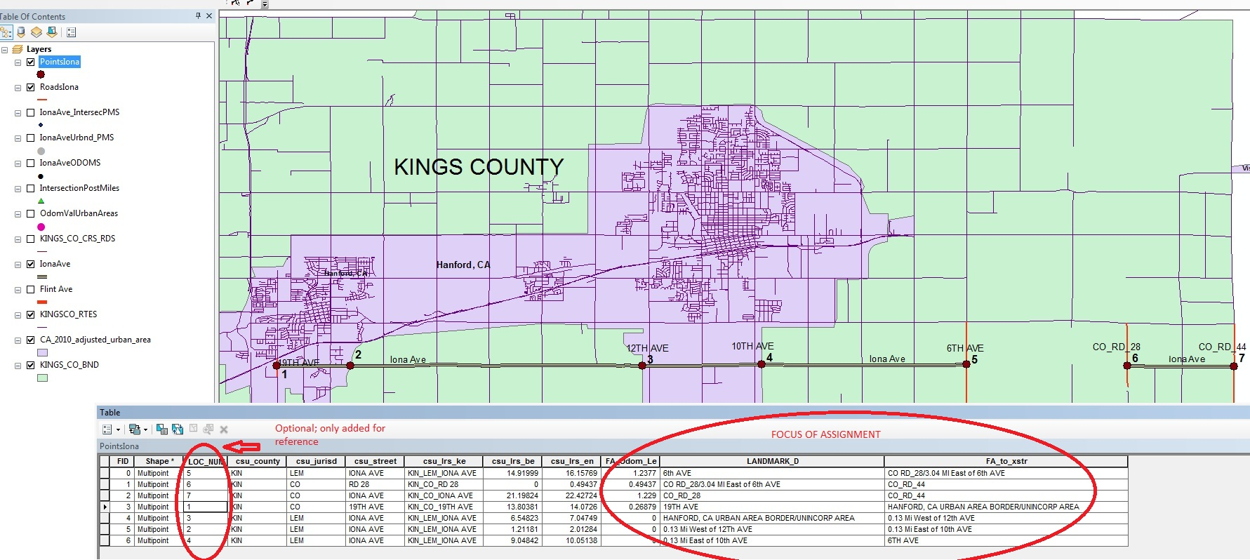
Your example does not answer my questions, because it is unfocused and you expect me to filter out the useless segments in the table view and reorder the segments in my mind to find the measure patterns you expect. That is not worth my time or anyone else's.
Set the table view to only show selected records. Then using Iona Ave as an example, select only those segments that you are interested in on that route, i.e., select just the segments that you care about for a single measure pattern. I assume you would select the segments in just the urban areas, but I cannot be sure. Whatever you select should be sorted by the measure fields so I can determine what pattern your measures should follow. If the measures shown in the table are not the actual final measure values you really want/expect, create some new fields and write the actual values you expect or overwrite the values in the existing fields using a graphics program.
- Mark as New
- Bookmark
- Subscribe
- Mute
- Subscribe to RSS Feed
- Permalink
I think I may be able to work out the solution, but I need to confirm some assumptions I have about the original data you have. I assume you have:
1. A polyline feature class/shapefile containing a set of polyline segments that make up a highway network.
A. Each highway is made up of many polyline segments.
B. Each polyline segment contains a field containing a highway ID value that can be used to select all of the polylines that make up a complete highway.
C. Each polyline contains a pair of double fields listing the From and To postmile values for that polyline.
D. The From field value is always lower than the To field value so that the postmile measures are always increasing.
E. The orientation of the polyline geometry matches the orientation of the From and To postmile measures.
F. The highways are generally using a single centerline to represent bidirectional travel rather than a dual centerline to represent each direction of travel separately.
G. The polyline segments have had some topological validation to eliminate most dangles, self-intersections and overlaps where segments meet end to end.
H. You are only concerned with postmile distances along highway through lanes and you can easily exclude highway ramps that may be in the network from this analysis.
I. If any branching occurs you are willing to isolate and process these branches separately. This may happen at interchanges or along highway's that alternate between single centerlines and dual centerlines as the directions of travel alternately parallel and diverge from each other along a given route,
2. A polygon feature class/shapefile containing urban and rural boundaries.
A. The polygons have been created separately from the highway network and/or there has been little or no topological control where the polygons and the polylines are supposed to represent the same boundary/centerline.
B. The polygons have not been topologically validated and in all likelihood contain small slivers and gaps between boundaries that are supposed to be identical. (This only poses a concern along boundaries that follow highway centerlines for the purposes of this assignment).
I am assuming you do not already have a LRS route network that actually has stored the calibrated postmile measure coordinates in the highway polyline geometry. If your polyline network actually stores measure coordinates in the polyline geometry that match the From and To measures of your fields that eliminates a large section of steps and is critical to know. Looking at your original post it appears you may have some kind of LRS routes with postmile measures already available, so it is crucial to know if that is the case and how it relates to the polyline segments you are trying to process.
Almost every highway network has some geometry that does not follow the simple rules that only apply to simple routes that have non-repeating increasing measures. No program exists that can cover every possible real world highway configuration without some manual intervention. If you do not already have a validated LRS route network and are provided steps that work for more than 90% of your network, you will have to be satisfied with that. The law of diminishing returns sets in for the last 10% where it usually is less time consuming and more accurate to process it manually than it is to try to develop a programmatic approach, unless you are dealing with a massive data set at least 100 times larger than 2500 segments.