- Home
- :
- All Communities
- :
- Industries
- :
- Telecommunications
- :
- Telecommunications Blog
- :
- Network Transformation: Strategic Planning, Remote...
Network Transformation: Strategic Planning, Remote Engineering, & Operational Awareness
- Subscribe to RSS Feed
- Mark as New
- Mark as Read
- Bookmark
- Subscribe
- Printer Friendly Page
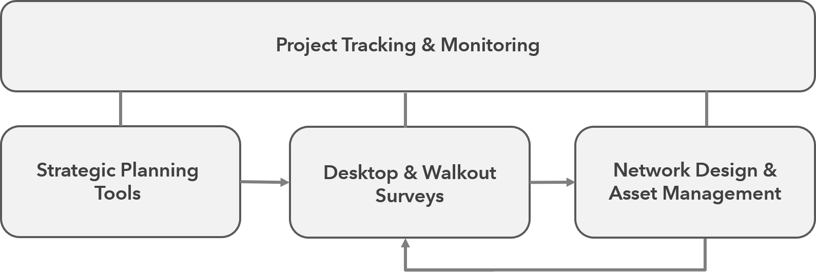
In the last Geospatially Enabling Telecom blog we discussed Network Transformation and the impact 5G will have on communications networks. To support Network Transformation, Esri and its Partner's solutions can be categorized into 4 main business offerings; Strategic Planning Tools, Desktop & Walkout Surveys, Network Design & Asset Management, and Project Tracking & Monitoring. While, the main focus of the previous blog was around Network Design & Asset Management solutions, this blog will take a look at the other solutions in these Network Transformation offering areas.
Strategic Planning Tools
Deployment of new wireless technologies, like 5G, and improvements to existing wireless networks are causing service providers to densify both their wireless antennas and their fiber networks. But with limited CAPEX, services providers need to be strategic in where and when they perform network densification. Esri offers spatial analytical tools and models to help understand where network transformation should occur based historical network performance, market analysis, and business requirements. These tools can run in a desktop or server environment on hundreds or millions of data points. In the video below, a few of the Strategic Planning Tools are shown, including;
- Clustering : Identifies statistically and geographically significant cluster of features
- Snapping : Snaps features to lines and polygons for aggregated totals
- Spatial Aggregation/Binning : Aggregates and summarizes features to other features like hexagon polygons
- GeoEnrichment/Spatial Join : Appends attributes from one set of features to another set of features based on location
- Site Suitability : Locate ideal locations based on overlaying and weighting input features
- Space/Time Prediction : View patterns and trends over geographic space and time
- ML Image Classification : Locate features in images or imagery based on training datasets
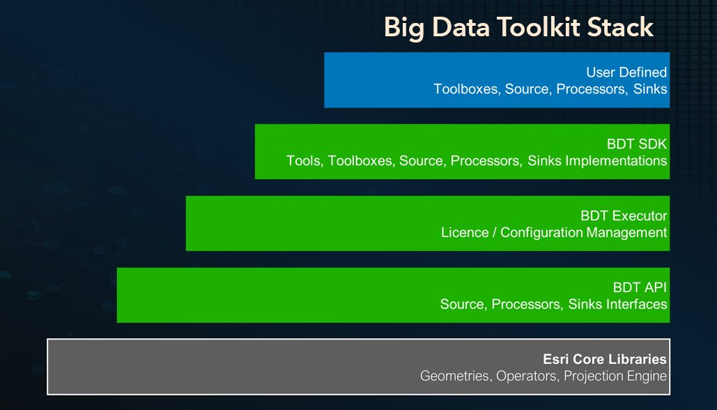
Big Data Toolkit
A new deployment option for the Strategic Planning Tools solution that has recently gained a lot of attention from ArcGIS users is the Big Data Toolkit. This toolkit contains core ArcGIS spatial analysis tools that can be deployed into big data environments like Hadoop, and are run through Spark jobs. This allows analysts to bring ArcGIS spatial analysis tools directly to large datasets, distribute analysis across nodes in a cluster, and perform spatial operations without spatial indexing, drastically improving performance and speed.
Getting Started with Strategic Planning Tools
To deploy the Strategic Planning Tools within your organization, you have 3 main options, including Big Data Toolkit, depending on the analysis workflow and size of the datasets:
- ArcGIS Pro and ArcPy Python spatial libraries (core ArcGIS tools typically ran within a desktop environment)
- GeoAnalytics Server and Spatiotemporal Data Store (big data spatial analysis, bring the data to ArcGIS)
- Big Data Toolkit and ArcGIS (big data spatial analysis, bring ArcGIS to the data)
For more information on Esri's Strategic Planning Tools, check out this Story Map. https://arcg.is/1H1XH4
Desktop & Walkout Surveys
While complete remote engineering is what we all strive for, its not always the case, and rolling a truck for pole audits and walkout surveys is part of the engineering process. Esri offers solutions for Desktop & Walkout Surveys that can help reduce truck rolls or site visits, while improving the efficiency of field work. Some of the ways that these ArcGIS solutions can aid your engineers and automate workflows are:
Desktop Surveys
Automated fiber routing and if/then scenarios
Wireless planning and line of sight
Access to basemaps and geographic content from the Living Atlas
Heavy desktop solution or lightweight web apps
Integrated street view and image detection
Geographic data management
Walkout Surveys
- Cross platform configurable mobile apps
- Offline mobile map books
- Editing tools and redlining
- Location based geotagging of photos
- Integrated with Desktop Survey apps
Demo Video: Desktop & Walkout Survey Demo from Esri UC 2019
Getting Started with Desktop & Walkout Surveys
To get started and for more information, check out this story map: https://arcg.is/1zKbbX
Project Tracking & Monitoring
With the increased number of network build outs to support Network Transformation, project tracking and monitoring is more important today than ever before. Engineers are designing networks on top of each other and in near real-time, and sales and operations teams need to know when projects will be completed. So in order to make timely and accurate decisions, access to underlying data in an easy to interrupt format is a business necessity. Esri's Project Tracking & Monitoring solutions allow for visualizing data on a map or dashboard to better understand activities, projects, and operations. ArcGIS integrates existing data, metrics, and operational and analytical layers in a way that produces information valued by decision makers. Ensure all of your network transformation projects stay on time and on budget.
Demo Video: Project Tracking & Monitoring Demo from Esri UC 2019
Getting Started with Project Tracking & Monitoring
To get started and for more information, check out Network Transformation at esri.com/telecom.
Also, be sure to re-watch the Network Transformation Webinar from earlier this year to see all of the Esri solutions in action.
Network Transformation: Modeling Fiber - Part 1
In the next Geospatially Enabling Telecom blog we’ll expand upon the second blog of the series and further discuss the simple network management capabilities and workflows available today, and the advanced network management capabilities and workflows coming with the addition of Object Classes in the utility network and the release of the Industry Configuration for fiber. We'll also do a deeper dive on the first preview release of the fiber asset package data model. We'll follow up the 'Modeling Fiber' blog with additional blogs on the other Esri business offerings that support network transformation.
Please feel free to comment below on anything covered in this blog, and to provide feedback or offer suggestions on functionality you would like to see in any of the Esri network transformation business offerings, and for more information on all of Esri's solutions for telecommunications visit Esri.com/telecom.
Thanks,
- Esri Telecom Team
telug
You must be a registered user to add a comment. If you've already registered, sign in. Otherwise, register and sign in.