- Home
- :
- All Communities
- :
- Industries
- :
- State & Local Government
- :
- State & Local Government Questions
- :
- Map Book
- Subscribe to RSS Feed
- Mark Topic as New
- Mark Topic as Read
- Float this Topic for Current User
- Bookmark
- Subscribe
- Mute
- Printer Friendly Page
Map Book
- Mark as New
- Bookmark
- Subscribe
- Mute
- Subscribe to RSS Feed
- Permalink
I need to create multiple maps based off of individual polygons. I know you can create a map book or strip maps to create this, but Is there a way to generate individual maps based on all the individual polygons. Just trying to save some time instead of creating individual MXDs for each individual polygon. Any help is appreciated.
Thanks!
- Mark as New
- Bookmark
- Subscribe
- Mute
- Subscribe to RSS Feed
- Permalink
I have this same situation: I have a project area with parcel polygons that contain Tree locations. I need to create a map book that shows individual polys and associated tree_point locations.
- Mark as New
- Bookmark
- Subscribe
- Mute
- Subscribe to RSS Feed
- Permalink
If one wants to create a map based on individual polygons in a layer, those polygons can be used as the Index layer instead of the more typical Strip Index Map or Grid Index Map. See the example below:
The index layer does not have to be a grid. It can be map features. For example, you can create Data Driven Pages using a polygon layer of U.S. states. In this case, a page is created for each state.
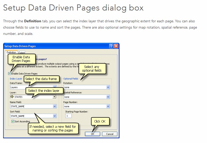
Source: Creating Data Driven Pages—Help | ArcGIS for Desktop
Chris Donohue, GISP
- Mark as New
- Bookmark
- Subscribe
- Mute
- Subscribe to RSS Feed
- Permalink
Chris,
I was messing around before you sent this and figured that out. Is there anyway to just show one specific individual polygon per map?
- Mark as New
- Bookmark
- Subscribe
- Mute
- Subscribe to RSS Feed
- Permalink
If the issue is that you would like to suppress other polygons in a layer except the single one of interest for that map (due to proximity, overlaps, potential confusion, etc), I believe it can be done with scripting, but I don't recall at the moment the particulars.
Chris Donohue, GISP