- Home
- :
- All Communities
- :
- Products
- :
- Spatial Statistics
- :
- Spatial Statistics Questions
- :
- Re: Spatial Autocorrelation for Rasters?
- Subscribe to RSS Feed
- Mark Topic as New
- Mark Topic as Read
- Float this Topic for Current User
- Bookmark
- Subscribe
- Mute
- Printer Friendly Page
Spatial Autocorrelation for Rasters?
- Mark as New
- Bookmark
- Subscribe
- Mute
- Subscribe to RSS Feed
- Permalink
Hi!
I wounder if it's possible to use Global Moran's I (spatial autocorrelation tool) on a pointlayer which is the result from a raster to point operation? I mean ofcourse it's _possible_ but is the result valid?
The reason I ask is because I get ridiculus high z-scores and wounder if I can really trust the results. I have searched to my best ability but no definite answear. I have found others recommending the raster to point operation.
My question is hence: can spatial autocorrelation be used on a raster (the points resulting in a raster to point)? Is that a correct way to use the tool or will the placement and amount of points disrupt the result?
About my data:
I have a shapefile with reported movementspath which are quite intricate polylines with overlaps of the own line and large differences in how large network each respondent have reported. The lines/respondents are divided in two groups (A & B).
I have made a density raster of for each group (both with the density tool and by counting the lines without respect to their lenght within radius (using spatial join & fishnet).
Then I have indexed the groups in respect to population and subtracted one from the other resulting in a index scale from -1 to +1 (in reality -0,20 to +0,29).
The pattern is very clear and give several intresting thesis and thoughts. However now I want to make sure the differences I see are statistically significant.
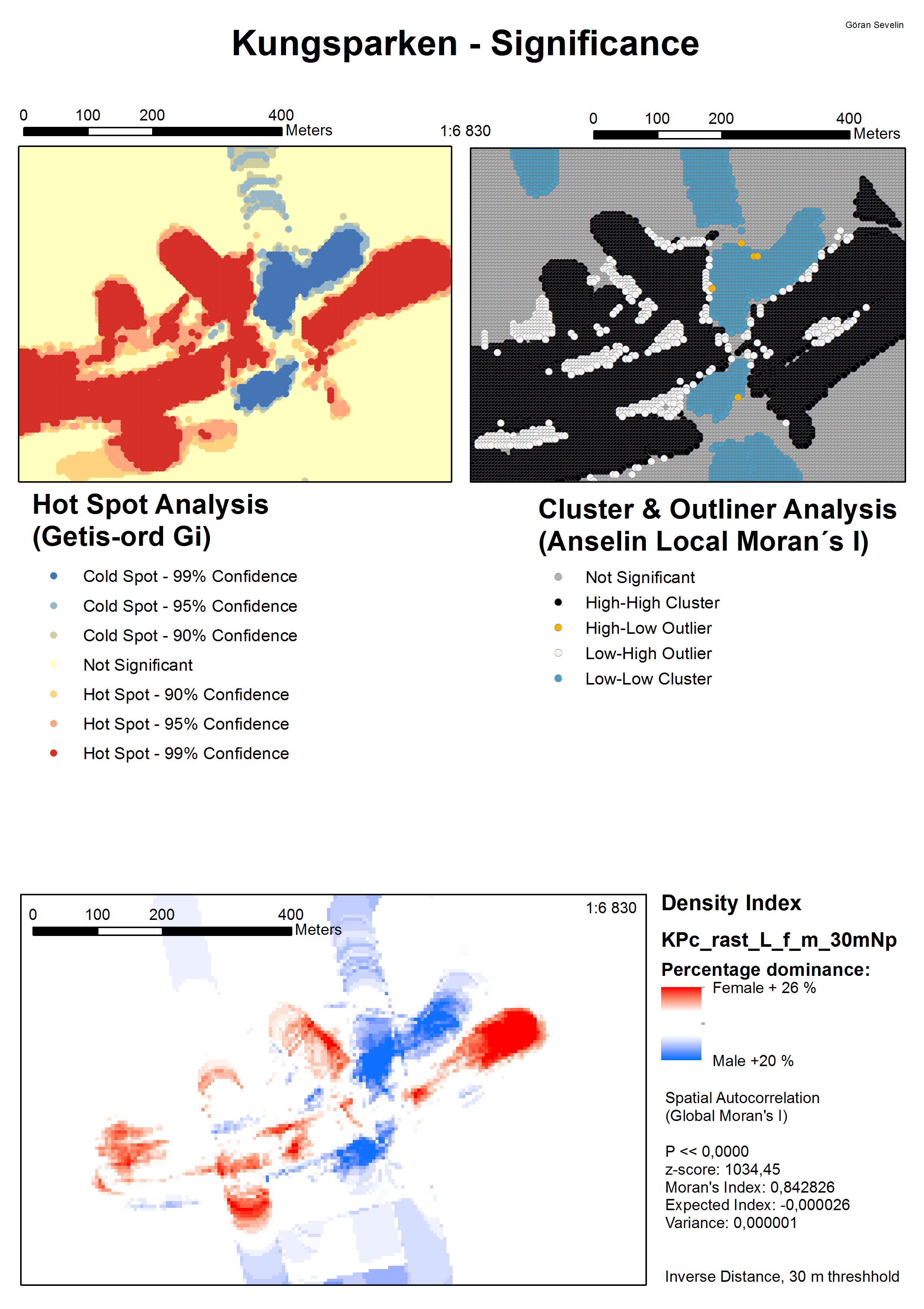
I have used Global Moran's I as well as Hot Spot (Getis-ord Gi) and cluster analysis (Anselin Local Moran's I)
All result in high significance. The z-score for Global Moran's I vary between 165 and 265 depending on the radius of the distance threshold (10 to 100 meter)(for one of the density layers, the others give similar results). Moran's vary between 0,36 and 0,07 for the same.
Grateful for any help!
- Mark as New
- Bookmark
- Subscribe
- Mute
- Subscribe to RSS Feed
- Permalink
Is this a question? Because if it is, it is not clear to me what you question is.
There is a Spatial Statistics place that might give you more feedback, providing you formulate the question.
See Moving Content The GIS and Eduction places as well as you personal place, is not the right place for this content.
- Mark as New
- Bookmark
- Subscribe
- Mute
- Subscribe to RSS Feed
- Permalink
Sorry for the error in placement, I'm a newbie on this community. I have added the third paragraph to hopefully clarify my question.
- Mark as New
- Bookmark
- Subscribe
- Mute
- Subscribe to RSS Feed
- Permalink
Thank for the fast follow-up. The question is totally clear now!
Although the information on the GeoNet Help may be overwhelming, it might be good to browse through it. A new landing place is under construction as we speak that will provide a better experience in getting acquainted with GeoNet.
- Mark as New
- Bookmark
- Subscribe
- Mute
- Subscribe to RSS Feed
- Permalink
What I read from the Help is that:
the tool measures spatial autocorrelation based on both feature locations and feature values simultaneously
Since you will have a regular distribution, this may influence the results.
Best practice guidelines
- Does the Input Feature Class contain at least 30 features? Results aren't reliable with less than 30 features.
- Is the Conceptualization of Spatial Relationships you selected appropriate? See Selecting a Conceptualization of Spatial Relationships.
- Is the Distance Band or Threshold Distance appropriate? See Selecting a Fixed Distance.
- All features should have at least one neighbor.
- No feature should have all other features as a neighbor.
- Especially if the values for the Input Field are skewed, you want features to have about eight neighbors each.
- Should you Row Standardize? For polygon features, you will almost always want to row standardize. See Standardization.
source: ArcGIS Help (10.2, 10.2.1, and 10.2.2)
And you may want to read on Modeling spatial relationships: ArcGIS Help (10.2, 10.2.1, and 10.2.2)
- Mark as New
- Bookmark
- Subscribe
- Mute
- Subscribe to RSS Feed
- Permalink
Yeah, that's what I been thinking that it may effect the result that the spatial distribution of features is even. Though I would very much like to have this clarified.
It would also be tremendously helpful if anyone knows a tool to measure statistical significance which is certain to be feasible on a raster.
- Mark as New
- Bookmark
- Subscribe
- Mute
- Subscribe to RSS Feed
- Permalink
Would this be a fair statement of your current condition regarding: the form of the data that you have, the sample size and how it was collected.
"The nature and form of the data collected at present, does not permit testing of the observed patterns for significance using standard methods. This will be addressed in further studies."
Perhaps it shouldn't be spatial statistics that you should be using, but simpler inferential statistics which can address associations/differences with respect to patterns in a more generalized manner.
- Mark as New
- Bookmark
- Subscribe
- Mute
- Subscribe to RSS Feed
- Permalink
 That might be a valid statement but I do hope that I will not need to write it in my study but rather find a solution or workaround.
You'r right that I would like to say something about the population based on my sample. Any tips on where in the subject of inferential statistics I might find something useful?
- Mark as New
- Bookmark
- Subscribe
- Mute
- Subscribe to RSS Feed
- Permalink
Perhaps, but it would be more useful to post an image of the patterns that you have, rather than post zip files of data, for which most people won't have the time to download, unzip and analyse,