- Home
- :
- All Communities
- :
- Products
- :
- Spatial Data Science
- :
- Spatial Data Science Questions
- :
- Re: select polylines with same field name as point...
- Subscribe to RSS Feed
- Mark Topic as New
- Mark Topic as Read
- Float this Topic for Current User
- Bookmark
- Subscribe
- Mute
- Printer Friendly Page
select polylines with same field name as points layer
- Mark as New
- Bookmark
- Subscribe
- Mute
- Subscribe to RSS Feed
- Permalink
I am primarily trying to do this in Geomedia Professional but ArcGIS is my "native" GIS language so here goes. I did a version of what I want in Geomedia but the result was screwy. The main reason I'm posting on this board is to learn what are the same types of commands or tools I need to use in Geomedia.
I have a points layer of all the locations where a streets layer intersected a polygon. The points layer has the same street name field as the streets layer.
I ultimately want to create a streets layer of all the streets that intersect the polygons. I have thought one way to do this is using a Field Equation of Street Name (points layer) = Street Name (polyline layer). However I can't seem to figure out the correct syntax for a field equation in the points layer, and even if I add a text field for Field Equations, it gives me numbers in the field automatically??! I thought you could Select by Points? I did see there's an Extract By Points function in ArcTool Box but you need a Network Analyst license to do it and we don't have one.
In Geomedia, the Join Functionality allows you to do exactly what I want (use street field names from both layers) but it ends up giving me more street segements than are actually intersecting the polygons. Bizarre.
I've attached some Jpgs of what happened in Geomedia.
Thanks,
Dan B
- Mark as New
- Bookmark
- Subscribe
- Mute
- Subscribe to RSS Feed
- Permalink
I ultimately want to create a streets layer of all the streets that intersect the polygons.
Why not Clip the streets by the polygon layer?
- Mark as New
- Bookmark
- Subscribe
- Mute
- Subscribe to RSS Feed
- Permalink
Help me this way.
Put the polyline file on top of the polygon file.
Notice in the table the Distance value is 0-0.503.
I need 3 segments with 3 different lengths--0-x, x-0.503, 0.503-x.
How do I split the polyline so that I can get 3 different values?
Add fields if need be.
If this can be done in Geomedia Professional 6.1 then terrific.
Thank you.
- Mark as New
- Bookmark
- Subscribe
- Mute
- Subscribe to RSS Feed
- Permalink
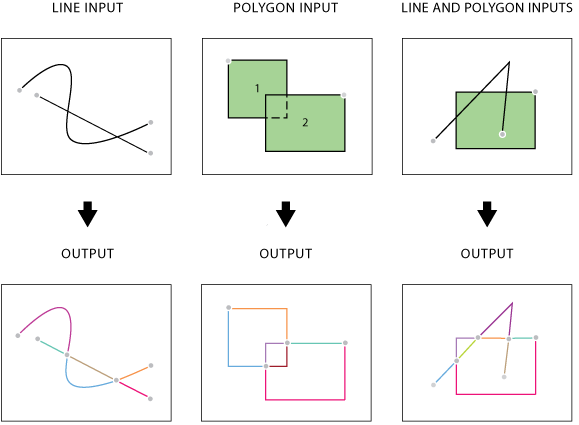
It sounds like you'd want Feature to Line for this (Advanced License required) - the third situation below.

Alternatively, since you've already go the intersection points, you could use Split Line at Point (also requires Advanced License).
- Mark as New
- Bookmark
- Subscribe
- Mute
- Subscribe to RSS Feed
- Permalink
I don't have an Advanced License, that's why I'm posting and asking for
your help.
Did you try to do what I was asking?
Please?
Honestly, it shouldn't be that hard to Re-Calibrate or Re-Calculate
odometer values once a segment length changes.
Yes the two segments both have the same begin and end measures (0 - 0.503),
but what does it take to convert that into two separate values?
Dan
- Mark as New
- Bookmark
- Subscribe
- Mute
- Subscribe to RSS Feed
- Permalink
I did look at your data, but I'm really lost on what exactly you're asking. Your line was split into three segments, so it seems you know how to do that. Please try rephrasing your question if you want more help from me.
- Mark as New
- Bookmark
- Subscribe
- Mute
- Subscribe to RSS Feed
- Permalink
What is it that you are lost on?
Instead of one segment with the same measurement0-0.503I need 3
segments (e.g., select segments that are within Urban Area == 1 shapefile,
select segments that are Outside of Urban Area == 1 shapefile), but then
instead of the segments all still having 0-0.503, I need to re-calculate
the distance for each segment and have it appear sequentially. In this
case:
Urban segment 1: 0-x.
Rural segment 1: x-y.
Urban segment 2: y-0.503.
The problem I have is that no matter what I seem to do in Geomedia 6.1
using its Analytical Merge function, and creating new Begin and End fields
for measures for the segments, I am always getting 2 segments of 0-0.503,
and then something else equally wacky.
Have you used Geomedia 6.1? If you haven't then that may be a problem
because this project is centered around using it for certain things but
there is a lot that ArcGIS 10.x can do that Geomedia
Professional/Transportation Manager can't.
- Mark as New
- Bookmark
- Subscribe
- Mute
- Subscribe to RSS Feed
- Permalink
Have you ever worked with Geomedia?
Have you worked with the Transportation Manager extension in Geomedia?
If you have then you would know adequately what I am talking about in terms
of recalculating values.
- Mark as New
- Bookmark
- Subscribe
- Mute
- Subscribe to RSS Feed
- Permalink
Seems a bit rude. Darren has tried to help, but your question is confusing. It's hard to even tell if you want an ArcGIS solution or a Geomedia one. Maybe there is a Geomedia forum you could ask on?