- Home
- :
- All Communities
- :
- Products
- :
- Spatial Data Science
- :
- Spatial Data Science Questions
- :
- Directionality issues
- Subscribe to RSS Feed
- Mark Topic as New
- Mark Topic as Read
- Float this Topic for Current User
- Bookmark
- Subscribe
- Mute
- Printer Friendly Page
Directionality issues
- Mark as New
- Bookmark
- Subscribe
- Mute
- Subscribe to RSS Feed
- Permalink
Hi all,
I have a shp with cycling routes and I would like to draw out directionality's data.
I realise that through the network analyst tool I can get some directionality information but it works for the "new Route" analysis layer and I can not use it for my shp.
Do you know how could I get this information in a different way?
I appreciate any suggestions.
Thank you in advance,
George
- Mark as New
- Bookmark
- Subscribe
- Mute
- Subscribe to RSS Feed
- Permalink
I am not certain what an Antennas directional sensitivity would have to do with it.
The issue your most likely having is your getting mixed around by the digitized direction. i.e. the direction the line was originally drawn. You can use the Flip to change digitized direction.
- Mark as New
- Bookmark
- Subscribe
- Mute
- Subscribe to RSS Feed
- Permalink
Hi Robert,
thank you for your answer.
I want the draw out information about the routes directionality e.g. north, south, west..., for the whole route or for the every segment of the route.
Do you have any suggestion for me?
Thanks,
George
- Mark as New
- Bookmark
- Subscribe
- Mute
- Subscribe to RSS Feed
- Permalink
I believe you will simply have to go to each route and set the digitized direction to the direction you want.
Make your line symbol to be Arrow at End (preset symbol) and you can easily see which end is which.
The you can right click on a line and select flip or select multiple lines and use the FLIP LINE tool to quickly flip one or multiple lines.
suggestion, Create a custom toolbar and put common tools in there and have it floating. Or as I like to do create a hot key command for a specific tool.
- Mark as New
- Bookmark
- Subscribe
- Mute
- Subscribe to RSS Feed
- Permalink
As I understood with the flip tool I can change the direction of a line. Please correct me if I am wrong.
I want directionality information (e.g. north, south etc. ) from a shp to draw out e.g. on an excel file, for the whole line or for any segment of the line.
Actually, with the Network Analyst tool I can have some of this information but it only possible from the analysis tool layer and not for the shp.
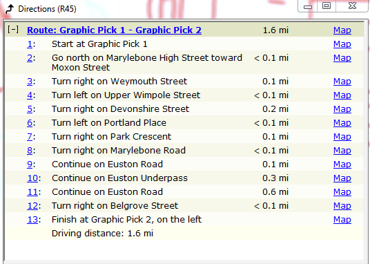
Please see attached.
- Mark as New
- Bookmark
- Subscribe
- Mute
- Subscribe to RSS Feed
- Permalink
So then put the shape file in a database
- Mark as New
- Bookmark
- Subscribe
- Mute
- Subscribe to RSS Feed
- Permalink
Do you know what steps I have to follow since I am confused about how I can do it?
Thank you!
- Mark as New
- Bookmark
- Subscribe
- Mute
- Subscribe to RSS Feed
- Permalink
Start ArcCatalog create a new database, create a new dataset with the appropriate projection, import the shape file.
- Mark as New
- Bookmark
- Subscribe
- Mute
- Subscribe to RSS Feed
- Permalink
OK. Thank you. When I create the database how will I get the directionality data?
- Mark as New
- Bookmark
- Subscribe
- Mute
- Subscribe to RSS Feed
- Permalink
The say way you got it with your attachment.