- Home
- :
- All Communities
- :
- Industries
- :
- Science
- :
- Science Questions
- :
- Re: Join us for a GeoNet AMA (Ask Me Anything) wit...
- Subscribe to RSS Feed
- Mark Topic as New
- Mark Topic as Read
- Float this Topic for Current User
- Bookmark
- Subscribe
- Mute
- Printer Friendly Page
Join us for a GeoNet AMA (Ask Me Anything) with Dawn Wright, Esri Chief Scientist
- Mark as New
- Bookmark
- Subscribe
- Mute
- Subscribe to RSS Feed
- Permalink
Event details:
• What: Join us, with special guest Dawn Wright, Esri Chief Scientist, for an AMA (Ask Me Anything) live on the GeoNet Community in the Sciences group. Ask Dawn anything about science, GIS, her work at Esri (including the relationship of Esri to the scientific community), what's coming up at AGU, and any fun, interesting and thought-provoking questions.
• When: The AMA event will take place in this discussion thread on Friday December 8, 2017 from 10:00am-11am PT.
How to participate:
• During the AMA, if you are logged into GeoNet, you can post your questions in the comments below and Dawn will reply to your questions in the comments.
• You're welcome to post questions ahead of the AMA but we won't begin answering them until the AMA begins on December 8th at 10:00am PT.
Reminder: AMA Tips and GeoNet Community Guidelines
• You will need a GeoNet account in order to participate. If you don't have one, you can create one here.
• When asking questions and comments during the AMA, remember to follow the GeoNet Community Guiding Principles.
• During the AMA this discussion page will not auto-refresh, so please remember to refresh this page to see new questions, comments and replies.
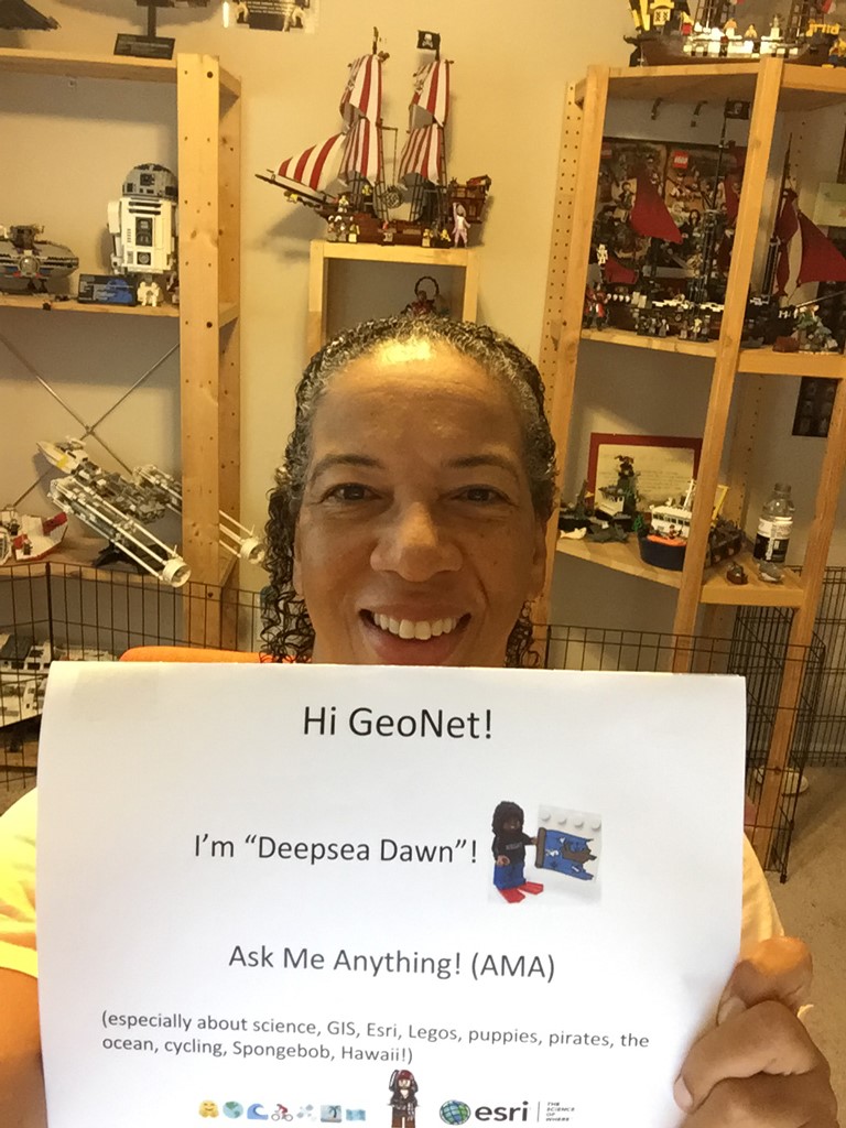
You'll know the AMA is live when you see the picture below with Dawn. And then remember to refresh the page to see our updates and new questions and comments.
Thanks for joining us and we'll see you then!
10:00 am - And we're live! Go ahead and ask your questions!
10:30 am - We're halfway through. Great questions! Keep 'em coming!
10:55 am - Five minutes to go! Got any fun questions for Dawn?
11:00 am - Overtime! We'll continue to take your questions during this bonus 10 minutes!
11:10am - And that's a wrap! The live AMA has ended but Dawn will continue to answer questions as schedules allow. Thanks for joining us and asking great questions!
Manager, Community Experience & Programs
- Mark as New
- Bookmark
- Subscribe
- Mute
- Subscribe to RSS Feed
- Permalink
And adding, any women regardless of age  I'm working on building a new career path.
- Mark as New
- Bookmark
- Subscribe
- Mute
- Subscribe to RSS Feed
- Permalink
Yes, great point Megan! A lot of the tips mentioned can apply to people of all ages. The Esri YPN is for people of all ages too. "Young Professional" can mean that you are "young" within the geospatial profession (maybe as a second or third career) but mature in age!
Dawn Wright (she/her/hers), Ph.D. & GISP | Esri Chief Scientist
- Mark as New
- Bookmark
- Subscribe
- Mute
- Subscribe to RSS Feed
- Permalink
Another great question! Thanks Denise! This is another topic that could/should be an AMA in and of itself, but quickly I would say for young women to:
- be confident in what they are doing and to KNOW that they are on the path to success in geospatial because it is such a hot field
- join advocacy groups such as the Esri Young Professionals Network, Young Professionals Network (YPN) | Esri GIS Community where there are so many great resources and meetups
- try your best to find not only a great mentor but an ADVOCATE. I can explain more in subsequent posts
- try your best to find travel resources to get to conferences such as the UC but also local GIS user group meetings, smaller geospatial tech or science conferences, and the like
- get up the courage to PRESENT your own work at these conferences, which are also great places to get affirmation and good tips for improving your work
- start a resume or CV NOW at this point in your career
- get your own web presence (web site, blog) and business card
much more but will stop now due to time 
Dawn Wright (she/her/hers), Ph.D. & GISP | Esri Chief Scientist
- Mark as New
- Bookmark
- Subscribe
- Mute
- Subscribe to RSS Feed
- Permalink
Women In GIS – Network. Grow. Succeed.
Great group!
- Mark as New
- Bookmark
- Subscribe
- Mute
- Subscribe to RSS Feed
- Permalink
GREAT link! Thanks Joe! And I want to salute Joe here in this forum as the creator of the "Deepsea Dawn" lego minifig and Lego marine GIS lab. See this at the top of my Twitter feed: http://twitter.com/deepseadawn
Dawn Wright (she/her/hers), Ph.D. & GISP | Esri Chief Scientist
- Mark as New
- Bookmark
- Subscribe
- Mute
- Subscribe to RSS Feed
- Permalink
Please suggest some substantive and effective ways that Esri Business Partners and Non-Profit Organizations can leverage ArcGIS to deflect and reverse the unprecedented onslaught against science and conservation by the current administration and congress in the US. Thanks Dawn!
- Mark as New
- Bookmark
- Subscribe
- Mute
- Subscribe to RSS Feed
- Permalink
Hi Wetherbee! Great question as it speaks to how so many in our community may be feeling. These are interesting times. I think the best thing that business partners and non profits can do is to stay the course with the great work that you are already doing. Despite an onslaught that we may feel at the federal level, there is so much excellent work that is being done at the federal level (e.g., by NOAA, NASA, USGS and others who work with the business partner and non profit communities), but ALSO at the state and local level. For instance, it is heartening to see the cities and states that are moving forward with Paris Climate Agreement goals, principles, and milestones, making that commitment regardless.
Dawn Wright (she/her/hers), Ph.D. & GISP | Esri Chief Scientist
- Mark as New
- Bookmark
- Subscribe
- Mute
- Subscribe to RSS Feed
- Permalink
What does a "typical" day as Esri's chief scientist look like? What are some of your day to day activities?
- Mark as New
- Bookmark
- Subscribe
- Mute
- Subscribe to RSS Feed
- Permalink
Day to day I'm on email and GeoNet!
But more seriously, the exciting thing about my job at Esri is that it is all about engaging and communicating. For instance, we have a new product manager for 3D mapping and analysis and we got together so that I could share with him the many projects going on under our science initiative and how best to connect him with my network of scientists using our software so that he can develop better use cases which will ultimately lead to improvements in our 3D products to serve scientists. In this meeting we were joined by Jack Dangermond (neat serendipity as he saw us and just sat down) who gave us both an overview of the history of how the company had approached 3D problems in the past, the data structures that had evolved, where we would like to go now given the various needs out there of our users and the disruptive technologies such as drones (in the air AND in the sea) that are game changers, etc. Later I ran into some colleagues who wanted to me show me some neat applications that they were developing for virtual reality mapping experiences (including a spin wearing an Oculus Rift virtual reality headset, and then discussing one of our new collaborations with the Southern California Coastal Water Research Project where we might develop a neat prototype with their estuary data. Another colleague wanted some advice as to where to publish an article based on some new spatial statistical approaches that his group had developed for interpolating data collected by a variety of mobile devices in the field. Of course, I SO spend large portions of every day doing email too! I was attending a panel discussion at a conference and as the distinguished panelists introduced themselves (“I’m XX and I’m a marine ecologist,” "I'm YY and I specialize in marine spatial planning," etc., etc.), this one panelist said, “My name is XX and I do email!”
Dawn Wright (she/her/hers), Ph.D. & GISP | Esri Chief Scientist
- Mark as New
- Bookmark
- Subscribe
- Mute
- Subscribe to RSS Feed
- Permalink
Thanks for taking the time to share your insights.