Turn on suggestions
Auto-suggest helps you quickly narrow down your search results by suggesting possible matches as you type.
Cancel
- Home
- :
- All Communities
- :
- Developers
- :
- Python
- :
- Python Questions
- :
- Topo to Raster Batch Process question (Python newb...
Options
- Subscribe to RSS Feed
- Mark Topic as New
- Mark Topic as Read
- Float this Topic for Current User
- Bookmark
- Subscribe
- Mute
- Printer Friendly Page
Topo to Raster Batch Process question (Python newbie)
Subscribe
7417
12
07-09-2012 01:00 PM
07-09-2012
01:00 PM
- Mark as New
- Bookmark
- Subscribe
- Mute
- Subscribe to RSS Feed
- Permalink
Hi,
I've searched and researched and sampled but I'm hitting the wall here.
I'm trying to run Topo to Raster on 500+ inputs (topo contours and lake boundaries). I've tried to follow samples and examples in books and I think my workflow is going in the right direction but I'm getting an error, and hoping that someone can find my mistake. I've got all of the files in one directory and I defined my variables with a wildcard which is where I think my problem is but I'm not sure how to define the variable. For example the topo line feature is made up of 519 seperate files that have the naming convention "topo_ras_input_topoSection1","topo_ras_input_topoSection2" The lakes boundary file have a similar naming convention: "topo_ras_input_watersecSection1".
After I defined my variables I then list all of the feature classes and then use a for statement to start iterating through the list, I really should end up with 519 rasters as output but I'm not sure how to specify that either.
My code (I use that term loosely) is attached. Thanks in advance for your help.
12 Replies
07-19-2012
09:56 AM
- Mark as New
- Bookmark
- Subscribe
- Mute
- Subscribe to RSS Feed
- Permalink
try it as
arcpy.sa.TopoContour
you will likely need it for
arcpy.sa.Topolake
and
arcpy.sa.TopoToRaster
If you use
from arcpy.sa import *
in your imports, you won't need to specify the module,
but it can be confusing that way
arcpy.sa.TopoContour
you will likely need it for
arcpy.sa.Topolake
and
arcpy.sa.TopoToRaster
If you use
from arcpy.sa import *
in your imports, you won't need to specify the module,
but it can be confusing that way
07-19-2012
12:26 PM
- Mark as New
- Bookmark
- Subscribe
- Mute
- Subscribe to RSS Feed
- Permalink
Thanks for all the help Mark, that did the trick. Now I get to kick the process off and see what happens!
I was able to use the Model Builder iterator with Topo To Raster but without the water boundary parameter, it will be interesting to compare results.
Andy
I was able to use the Model Builder iterator with Topo To Raster but without the water boundary parameter, it will be interesting to compare results.
Andy
try it as
arcpy.sa.TopoContour
you will likely need it for
arcpy.sa.Topolake
and
arcpy.sa.TopoToRaster
If you use
from arcpy.sa import *
in your imports, you won't need to specify the module,
but it can be confusing that way
03-11-2015
03:53 AM
- Mark as New
- Bookmark
- Subscribe
- Mute
- Subscribe to RSS Feed
- Permalink
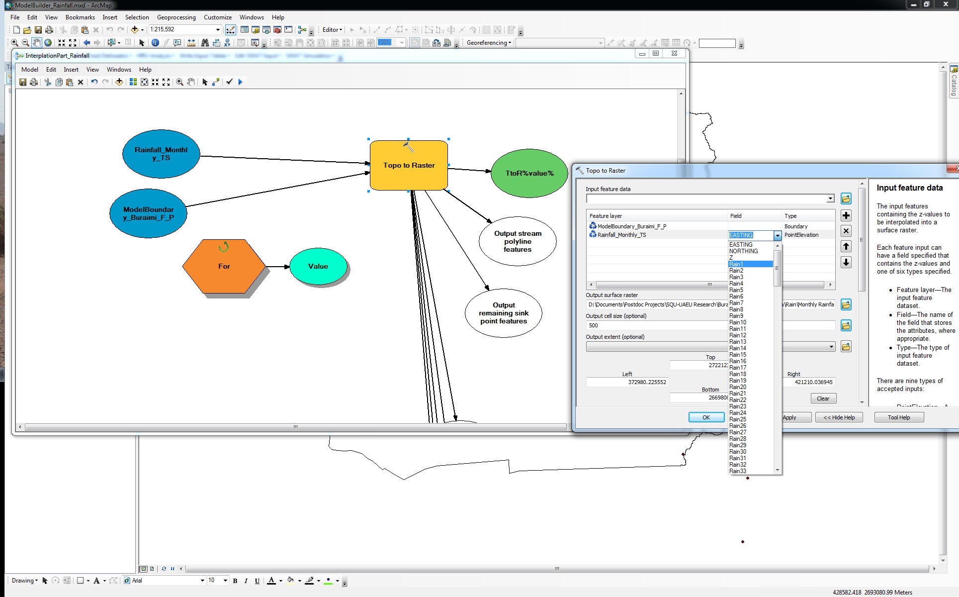
Dear Andrew,
Based on your post, "I was able to use the Model Builder iterator with Topo To Raster"; I want to use the Model Builder iterator (For iterator) to run “Topo To Raster” on 200+ inputs. But, when I want to write a dynamic name ("***%value%") in the field part of topo to raster window (attached screenshot) to iterate the computations, it is automatically changed to the first column of dataset. I did the same way for other interpolation methods (IDW & Spline) and they totally worked. Is there any hint about using iterator for “Topo To Raster” tool in the Model Builder? Thank you in advance for your generous help.
- « Previous
-
- 1
- 2
- Next »
- « Previous
-
- 1
- 2
- Next »