- Home
- :
- All Communities
- :
- Developers
- :
- Python
- :
- Python Questions
- :
- Solving 3 non linear algebraic equations in python...
- Subscribe to RSS Feed
- Mark Topic as New
- Mark Topic as Read
- Float this Topic for Current User
- Bookmark
- Subscribe
- Mute
- Printer Friendly Page
Solving 3 non linear algebraic equations in python
- Mark as New
- Bookmark
- Subscribe
- Mute
- Subscribe to RSS Feed
- Permalink
How can I solve a non-linear algebraic equation in ArcGIS python over multiple rasters. Let me Rephrase. I want to solve the following 3 non linear equations 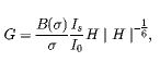 ,
, 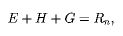 and
and  for 46 8 day time steps. I have 46 rasters each for an 8 day period for Β(σ) , and σ, where I need to take input values from per time step. Is/Io is a constant. The three unknowns I have are E, G and H. The solution should ideally produce 46 rasters each for the 3 unknowns. I don't know if this can be done in ArcGIS though. I know I can solve this equations easily in SciPy using the Fsolve function but I don't know how to get this working with rasters. Any code that could help will be greatly appreciated.
- Mark as New
- Bookmark
- Subscribe
- Mute
- Subscribe to RSS Feed
- Permalink
Larry you are going to have to edit your last code post so it is readable
plus I don't see where you have converted the input rasters to arrays using RasterToNumPyArray
perhaps show where you have one condition working first before you start with the batch part. Some may ask for a sample of the three inputs, so I will do it for them.
- Mark as New
- Bookmark
- Subscribe
- Mute
- Subscribe to RSS Feed
- Permalink
Below is the code formatted with a bunch of questions. In order to test anything sample data must be provided.
import os
import arcpy
import scipy
import numpy as np
def main():
arcpy.env.workspace = r"D:\GIS Data\Sixth Creek ET.gdb"
path1 = r"C:\Workspace\test geowrite\Betasigma"
path2 = r"C:\Workspace\test geowrite\sigma"
path3 = r"C:\Workspace\test geowrite\Netrad"
zGuess= np.array([1,1,1])
rasters = arcpy.ListRasters("*", "All") # where do you use this?
lst_files = [f for f in os.listdir(path1) if f.endswith(".tif")]
lst_fizes = [f for f in os.listdir(path2) if f.endswith(".tif")]
lst_fixes = [f for f in os.listdir(path2) if f.endswith(".tif")]
for i in range(0, 46):
# very risky to do this.
# does each folder have the same 46 raster?
# is the order the same so that the correct rasters will be used together?
path_ras_file = os.path.join(path1, lst_files[i])
path_ras_fize = os.path.join(path1, lst_fizes[i])
path_ras_fixe = os.path.join(path1, lst_fixes[i])
# I guess you will have to convert to numpy
# asuming all have the same dimensiones
np_file = arcpy.RasterToNumPyArray(arcpy.Raster(path_ras_file))
np_fize = arcpy.RasterToNumPyArray(arcpy.Raster(path_ras_fize))
np_fixe = arcpy.RasterToNumPyArray(arcpy.Raster(path_ras_fixe))
# your function uses a parameter. What is this parameter?
param ="define parameter!"
result_function = myFunction(param, np_file, np_fixe, np_fize)
# are you sure that all the necessary parameters are provided?
z = scipy.optimize.fsolve(result_function, zGuess)
# do something with the z
def myFunction(z, np_file, np_fixe, np_fize):
# what is z?
E = z[0]
G = z[1]
H = z[2]
F = np.empty((3))
F[0] = (np_file/np_fize) * 3 * H * pow(abs(H), -(1/6)) - G # can this be done with numpy arrays?
F[1] = np_fixe - E - H - G
F[2] = np_file * H - E
return F
if __name__ == '__main__':
main()- Mark as New
- Bookmark
- Subscribe
- Mute
- Subscribe to RSS Feed
- Permalink
https://drive.google.com/file/d/1dE32qKVm0V83d4pvmPUD0nWvDmrOaz3w/view?usp=sharing
Hi Xander, thanks for looking at the problem, I have included sample data in my google drive link above (3 each as against 46). A few things are over the top of my head really. I see I don't use the ListRasters command in the script at all, I guess not needed. Yes the rasters are arranged in order i.e the 46 in the same manner in each folder. I don't know about arrays either, just reading about them and the fsolve function. But I am sure the fsolve is able to solve the non linear equations as I tested it earlier using the code below but I replaced the rasters with actual numbers. I am not sure what you mean by parameter in line 32 as I did not add any such in the code below.
import arcpy
import scipy
import numpy as np
def myFunction(z):
... E = z[0]
... G = z[1]
... H = z[2]
... F = np.empty((3))
... F[0] = (3.356/1.024)*3*H*pow(abs(H),-(1/6))-G
... F[1] = 300-E-H-G
... F[2] = 3.356*H-E
... return F
zGuess= np.array([1,1,1])
z = fsolve(myFunction,zGuess)
print z
[ 70.96121951 207.89419779 21.14458269]
- Mark as New
- Bookmark
- Subscribe
- Mute
- Subscribe to RSS Feed
- Permalink
I'm sure to get in over my head, but it is one way to learn. So here goes...
I believe this is a way to pass additional information to fsolve. It produces the same result as your code example. I think you are trying to send file, fixe and fize to the function, correct? These values would come from your raster files.
import numpy as np
from scipy.optimize import fsolve
def myFunction(z, file, fixe, fize):
E = z[0]
G = z[1]
H = z[2]
F = np.empty((3,))
F[0] = (file/fize)*3*H*pow(abs(H),-(1/6))-G
F[1] = fixe-E-H-G
F[2] = file*H-E
return F
file = 3.356
fixe = 300
fize = 1.024
zGuess= np.array([1,1,1])
z = fsolve(myFunction, zGuess, args=(file,fixe,fize))
print z
#result: [ 70.96121951 207.89419779 21.14458269]- Mark as New
- Bookmark
- Subscribe
- Mute
- Subscribe to RSS Feed
- Permalink
Hi Randy,
Thanks for taking the shot. I tried this but it returned the same error. Pretty much not wanting to take in arrays or rasters. I have also included some sample raster data above.
- Mark as New
- Bookmark
- Subscribe
- Mute
- Subscribe to RSS Feed
- Permalink
I ran the code you wrote with corrections to the path as shown below and got the error
Runtime error
Traceback (most recent call last):
File "<string>", line 56, in <module>
File "<string>", line 36, in main
File "<string>", line 50, in myFunction
TypeError: only integer arrays with one element can be converted to an index
import os
import arcpy
import scipy
import numpy as np
def main():
arcpy.env.workspace = r"D:\GIS Data\Sixth Creek ET.gdb"
path1 = r"C:\Workspace\test geowrite\Betasigma"
path2 = r"C:\Workspace\test geowrite\sigma"
path3 = r"C:\Workspace\test geowrite\Netrad"
zGuess= np.array([1,1,1])
rasters = arcpy.ListRasters("*", "All") # where do you use this?
lst_files = [f for f in os.listdir(path1) if f.endswith(".tif")]
lst_fizes = [f for f in os.listdir(path2) if f.endswith(".tif")]
lst_fixes = [f for f in os.listdir(path3) if f.endswith(".tif")]
for i in range(0, 46):
# very risky to do this.
# does each folder have the same 46 raster?
# is the order the same so that the correct rasters will be used together?
path_ras_file = os.path.join(path1, lst_files[i])
path_ras_fize = os.path.join(path2, lst_fizes[i])
path_ras_fixe = os.path.join(path3, lst_fixes[i])
# I guess you will have to convert to numpy
# asuming all have the same dimensiones
np_file = arcpy.RasterToNumPyArray(arcpy.Raster(path_ras_file))
np_fize = arcpy.RasterToNumPyArray(arcpy.Raster(path_ras_fize))
np_fixe = arcpy.RasterToNumPyArray(arcpy.Raster(path_ras_fixe))
# your function uses a parameter. What is this parameter?
param ="define parameter!"
result_function = myFunction(param, np_file, np_fixe, np_fize)
# are you sure that all the necessary parameters are provided?
z = scipy.optimize.fsolve(result_function, zGuess)
# do something with the z
def myFunction(z, np_file, np_fixe, np_fize):
# what is z?
E = z[0]
G = z[1]
H = z[2]
F = np.empty((3))
F[0] = (np_file/np_fize) * 3 * H * pow(abs(H), -(1/6)) - G # can this be done with numpy arrays?
F[1] = np_fixe - E - H - G
F[2] = np_file * H - E
return F
if __name__ == '__main__':
main()- Mark as New
- Bookmark
- Subscribe
- Mute
- Subscribe to RSS Feed
- Permalink
it has to be a tuple of 3, notice the comma after the 3
F = np.empty((3,))
- Mark as New
- Bookmark
- Subscribe
- Mute
- Subscribe to RSS Feed
- Permalink
I fixed that and ran the code again and got the same result.
- Mark as New
- Bookmark
- Subscribe
- Mute
- Subscribe to RSS Feed
- Permalink
import os
... import arcpy
... import scipy
... import numpy as np
... def myFunction(z):
... E = z[0]
... G = z[1]
... H = z[2]
... F = np.empty((3))
... F[0] = (file/fize)*3*H*pow(abs(H),-(1/6))-G
... F[1] = fixe-E-H-G
... F[2] = file*H-E
... return F
...
... zGuess= np.array([1,1,1])
... arcpy.env.workspace ="D:/GIS Data/Sixth Creek ET.gdb"
... rasters = arcpy.ListRasters("*", "All")
... path = "C:\\Workspace\\test geowrite\\Betasigma\\"
... path2 = "C:\\Workspace\\test geowrite\\sigma\\"
... path3 = "C:\\Workspace\\test geowrite\\Netrad\\"
... files= [f for f in os.listdir(path) if f.endswith(".tif")]
... fizes= [f for f in os.listdir(path2) if f.endswith(".tif")]
... fixes= [f for f in os.listdir(path2) if f.endswith(".tif")]
... for i in range(0,46):
... file = path+files[i]
... fize = path2+fizes[i]
... fixe = path3+fixes[i]
... z = fsolve(myFunction,zGuess)
...
Runtime error
Traceback (most recent call last):
File "<string>", line 28, in <module>
File "C:\Program Files (x86)\python27\ArcGIS10.4\lib\site-packages\scipy\optimize\minpack.py", line 140, in fsolve
res = _root_hybr(func, x0, args, jac=fprime, **options)
File "C:\Program Files (x86)\python27\ArcGIS10.4\lib\site-packages\scipy\optimize\minpack.py", line 197, in _root_hybr
shape, dtype = _check_func('fsolve', 'func', func, x0, args, n, (n,))
File "C:\Program Files (x86)\python27\ArcGIS10.4\lib\site-packages\scipy\optimize\minpack.py", line 20, in _check_func
res = atleast_1d(thefunc(*((x0[:numinputs],) + args)))
File "<string>", line 10, in myFunction
TypeError: unsupported operand type(s) for /: 'str' and 'str'
- Mark as New
- Bookmark
- Subscribe
- Mute
- Subscribe to RSS Feed
- Permalink
Hi Larry Biodun , in order to be more efficient can you work in a IDE and copy the code without the indent points and error messages to have only the code preserving the indentation? It would require quite some editing to be able to run the code and the idea is when you insert code that it can be copied and executed, which is not the case right now. Just have a look at the code I inserted earlier.